

14 Water Resources in the Sahel and Adaptation …
325
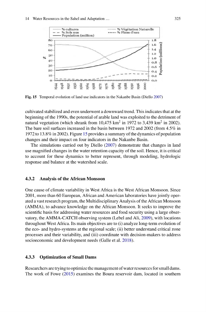
Fig. 15 Temporal evolution of land use indicators in the Nakanbe Basin (Diello 2007)
cultivated stabilized and even underwent a downward trend. This indicates that at the
beginning of the 1990s, the potential of arable land was exploited to the detriment of
natural vegetation (which shrank from 10,475 km
2 in 1972 to 3,439 km
2 in 2002).
The bare soil surfaces increased in the basin between 1972 and 2002 (from 4.5% in
1972 to 13.8% in 2002). Figure 15 provides a summary of the dynamics of population
changes and their impact on four indicators in the Nakanbe Basin.
The simulations carried out by Diello (2007) demonstrate that changes in land
use magnified changes in the water retention capacity of the soil. Hence, it is critical
to account for these dynamics to better represent, through modeling, hydrologic
response and balance at the watershed scale.
4.3.2 Analysis of the African Monsoon
One cause of climate variability in West Africa is the West African Monsoon. Since
2001, more than 60 European, African and American laboratories have jointly operated a vast research program, the Multidisciplinary Analysis of the African Monsoon
(AMMA), to advance knowledge on the African Monsoon. It seeks to improve the
scientific basis for addressing water resources and food security using a large observatory, the AMMA-CATCH observing system (Lebel and Ali, 2009), with locations
throughout West Africa. Its main objectives are to (i) analyze long-term evolution of
the eco- and hydro-systems at the regional scale; (ii) better understand critical zone
processes and their variability, and (iii) coordinate with decision-makers to address
socioeconomic and development needs (Galle et al. 2018).
4.3.3 Optimization of Small Dams
Researchers are trying to optimize the management of water resources for small dams.
The work of Fowe (2015) examines the Boura reservoir dam, located in southern
325
Fig. 15 Temporal evolution of land use indicators in the Nakanbe Basin (Diello 2007)
cultivated stabilized and even underwent a downward trend. This indicates that at the
beginning of the 1990s, the potential of arable land was exploited to the detriment of
natural vegetation (which shrank from 10,475 km
2 in 1972 to 3,439 km
2 in 2002).
The bare soil surfaces increased in the basin between 1972 and 2002 (from 4.5% in
1972 to 13.8% in 2002). Figure 15 provides a summary of the dynamics of population
changes and their impact on four indicators in the Nakanbe Basin.
The simulations carried out by Diello (2007) demonstrate that changes in land
use magnified changes in the water retention capacity of the soil. Hence, it is critical
to account for these dynamics to better represent, through modeling, hydrologic
response and balance at the watershed scale.
4.3.2 Analysis of the African Monsoon
One cause of climate variability in West Africa is the West African Monsoon. Since
2001, more than 60 European, African and American laboratories have jointly operated a vast research program, the Multidisciplinary Analysis of the African Monsoon
(AMMA), to advance knowledge on the African Monsoon. It seeks to improve the
scientific basis for addressing water resources and food security using a large observatory, the AMMA-CATCH observing system (Lebel and Ali, 2009), with locations
throughout West Africa. Its main objectives are to (i) analyze long-term evolution of
the eco- and hydro-systems at the regional scale; (ii) better understand critical zone
processes and their variability, and (iii) coordinate with decision-makers to address
socioeconomic and development needs (Galle et al. 2018).
4.3.3 Optimization of Small Dams
Researchers are trying to optimize the management of water resources for small dams.
The work of Fowe (2015) examines the Boura reservoir dam, located in southern