

282
I. Thiaw et al.
flows over a complex watershed according to a semi-distributed conceptual scheme
and an object-oriented approach. It incorporates several rain-flow models, such as
GSM, SOCONT, SAC-SMA, GR4J and HBV.
The RS Expert module of the software allows a thorough evaluation of simulation results. Automatic calibration is applied using different algorithms, such as
Shuffled Complex Evolution, developed by the University of Arizona (SCE-UA)
(Duan et al. 1994) and the Uniform Adaptive Monte Carlo (Gilks et al. 1998; Liu
2001). The coupled method, Latin Hypercube (Rosenbrock 1960), calculates the best
hydrological parameters according to a user-defined Objective Function (OF). For
fluvial propagation, Lag-Time, Kinematic-Wave, Muskingum-Cunge and St-Venant
are applied. In addition, the scenario-simulation module simulates weather scenarios
or other parameters to study the variability and sensitivity of model results.
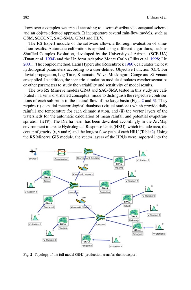
The two RS Minerve models GR4J and SAC-SMA tested in this study are calibrated in a semi-distributed conceptual mode to distinguish the respective contributions of each sub-basin to the natural flow of the large basin (Figs. 2 and 3). They
require (i) a spatial meteorological database (virtual stations) which provide daily
rainfall and temperature for each climate station, and (ii) the vector layers of the
watersheds for the automatic calculation of mean rainfall and potential evapotranspiration (ETP). The Diarha basin has been described accordingly in the ArcMap
environment to create Hydrological Response Units (HRU), which include area, the
center of gravity (x, y and z) and the longest flow-path of each HRU (Table 2). Using
the RS Minerve GIS module, the vector layers of the HRUs were imported into the
Fig. 2 Topology of the full model GR4J: production, transfer, then transport
I. Thiaw et al.
flows over a complex watershed according to a semi-distributed conceptual scheme
and an object-oriented approach. It incorporates several rain-flow models, such as
GSM, SOCONT, SAC-SMA, GR4J and HBV.
The RS Expert module of the software allows a thorough evaluation of simulation results. Automatic calibration is applied using different algorithms, such as
Shuffled Complex Evolution, developed by the University of Arizona (SCE-UA)
(Duan et al. 1994) and the Uniform Adaptive Monte Carlo (Gilks et al. 1998; Liu
2001). The coupled method, Latin Hypercube (Rosenbrock 1960), calculates the best
hydrological parameters according to a user-defined Objective Function (OF). For
fluvial propagation, Lag-Time, Kinematic-Wave, Muskingum-Cunge and St-Venant
are applied. In addition, the scenario-simulation module simulates weather scenarios
or other parameters to study the variability and sensitivity of model results.
The two RS Minerve models GR4J and SAC-SMA tested in this study are calibrated in a semi-distributed conceptual mode to distinguish the respective contributions of each sub-basin to the natural flow of the large basin (Figs. 2 and 3). They
require (i) a spatial meteorological database (virtual stations) which provide daily
rainfall and temperature for each climate station, and (ii) the vector layers of the
watersheds for the automatic calculation of mean rainfall and potential evapotranspiration (ETP). The Diarha basin has been described accordingly in the ArcMap
environment to create Hydrological Response Units (HRU), which include area, the
center of gravity (x, y and z) and the longest flow-path of each HRU (Table 2). Using
the RS Minerve GIS module, the vector layers of the HRUs were imported into the
Fig. 2 Topology of the full model GR4J: production, transfer, then transport