

12 Water Management Policy for Freshwater Security …
259
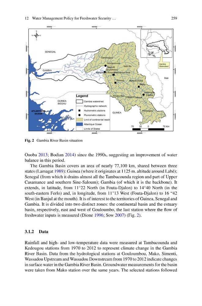
Fig. 2 Gambia River Basin situation
Ouoba 2013; Bodian 2014) since the 1990s, suggesting an improvement of water
balance in this period.
The Gambia Basin covers an area of nearly 77,100 km, shared between three
states (Lamagat 1989): Guinea (where it originates at 1125 m. altitude around Labé);
Senegal (from which it drains almost all the Tambacounda region and part of Upper
Casamance and southern Sine-Saloum); Gambia (of which it is the backbone). It
extends, in latitude, from 11°22 North (in Fouta-Djalon) to 14°40 North (in the
south-eastern Ferlo) and, in longitude, from 11°13 West (Fouta-Djalon) to 16 “42
West (in Banjul at the mouth). It is of interest to the territories of Guinea, Senegal and
Gambia. It is divided into two distinct zones: the continental basin and the estuary
basin, respectively, east and west of Gouloumbo, the last station where the flow of
freshwater inputs is measured (Dione 1996; Sow 2007) (Fig. 2).
3.1.2 Data
Rainfall and high- and low-temperature data were measured at Tambacounda and
Kedougou stations from 1970 to 2012 to represent climate change in the Gambia
River Basin. Data from the hydrological stations at Gouloumbou, Mako, Simenti,
Wassadou Upstream and Wassadou Downstream from 1970 to 2012 indicate changes
in surface water in the Gambia River Basin. Groundwater measurements for the basin
were taken from Mako station over the same years. The selected stations followed
259
Fig. 2 Gambia River Basin situation
Ouoba 2013; Bodian 2014) since the 1990s, suggesting an improvement of water
balance in this period.
The Gambia Basin covers an area of nearly 77,100 km, shared between three
states (Lamagat 1989): Guinea (where it originates at 1125 m. altitude around Labé);
Senegal (from which it drains almost all the Tambacounda region and part of Upper
Casamance and southern Sine-Saloum); Gambia (of which it is the backbone). It
extends, in latitude, from 11°22 North (in Fouta-Djalon) to 14°40 North (in the
south-eastern Ferlo) and, in longitude, from 11°13 West (Fouta-Djalon) to 16 “42
West (in Banjul at the mouth). It is of interest to the territories of Guinea, Senegal and
Gambia. It is divided into two distinct zones: the continental basin and the estuary
basin, respectively, east and west of Gouloumbo, the last station where the flow of
freshwater inputs is measured (Dione 1996; Sow 2007) (Fig. 2).
3.1.2 Data
Rainfall and high- and low-temperature data were measured at Tambacounda and
Kedougou stations from 1970 to 2012 to represent climate change in the Gambia
River Basin. Data from the hydrological stations at Gouloumbou, Mako, Simenti,
Wassadou Upstream and Wassadou Downstream from 1970 to 2012 indicate changes
in surface water in the Gambia River Basin. Groundwater measurements for the basin
were taken from Mako station over the same years. The selected stations followed