

4 Climate Change and Water Resources in West Africa …
77
In Burkina Faso, plowing reduces runoff by holding water in the soil. When the
plants reach an advanced vegetative stage, ridging, with well-known techniques such
as zaï, demi-lune, and mulching, allows the concentration of water in furrows. These
techniques use stony barriers, bunds, micro-dams, lowland development, etc. (GWP
2010).
In Senegal, because of irregular precipitation, especially pronounced from 1968
to 1998, farmers, on their own initiative or with the support of non-governmental
organizations, have developed strategies through crop diversification and conversion
to other economic sectors. Farmers are unable to accurately assess the effects of
precipitation until August, when it is too late to sow on the plateau, so they generally
take advantage of the opportunities offered by the topography of their respective environments, and develop practices that respond to the topo-sequence and the amount
of time ponds remain in different segments of the slope. Thus, lowland areas are
exploited with rice varieties adapted to the limited amount of water available in
short rainy seasons, which clears the banks while exposing rice-growing valleys to
silting. Moreover, the development of market gardening in rural areas, especially in
the dry season, indicates the awareness of farming communities to climate hazards.
3.4.3 Crop Insurance as a Response to Changes in Rainfall
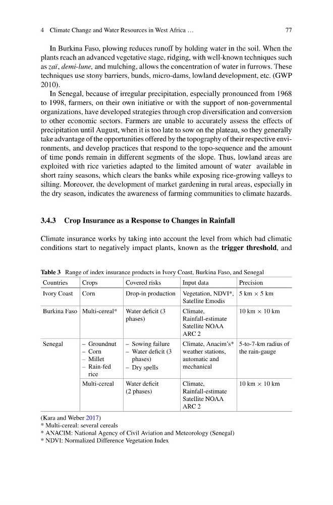
Climate insurance works by taking into account the level from which bad climatic
conditions start to negatively impact plants, known as the trigger threshold, and
Table 3 Range of index insurance products in Ivory Coast, Burkina Faso, and Senegal
Countries
Crops
Covered risks
Input data
Precision
Ivory Coast Corn
Drop-in production Vegetation, NDVI*,
Satellite Emodis
5 km × 5 km
Burkina Faso Multi-cereal* Water deficit (3
phases)
Climate,
Rainfall-estimate
Satellite NOAA
ARC 2
10 km × 10 km
Senegal
– Groundnut
– Corn
– Millet
– Rain-fed
rice
– Sowing failure
– Water deficit (3
phases)
– Dry spells
Climate, Anacim’s*
weather stations,
automatic and
mechanical
5-to-7-km radius of
the rain-gauge
Multi-cereal
Water deficit
(2 phases)
Climate,
Rainfall-estimate
Satellite NOAA
ARC 2
10 km × 10 km
(Kara and Weber 2017)
* Multi-cereal: several cereals
* ANACIM: National Agency of Civil Aviation and Meteorology (Senegal)
* NDVI: Normalized Difference Vegetation Index
77
In Burkina Faso, plowing reduces runoff by holding water in the soil. When the
plants reach an advanced vegetative stage, ridging, with well-known techniques such
as zaï, demi-lune, and mulching, allows the concentration of water in furrows. These
techniques use stony barriers, bunds, micro-dams, lowland development, etc. (GWP
2010).
In Senegal, because of irregular precipitation, especially pronounced from 1968
to 1998, farmers, on their own initiative or with the support of non-governmental
organizations, have developed strategies through crop diversification and conversion
to other economic sectors. Farmers are unable to accurately assess the effects of
precipitation until August, when it is too late to sow on the plateau, so they generally
take advantage of the opportunities offered by the topography of their respective environments, and develop practices that respond to the topo-sequence and the amount
of time ponds remain in different segments of the slope. Thus, lowland areas are
exploited with rice varieties adapted to the limited amount of water available in
short rainy seasons, which clears the banks while exposing rice-growing valleys to
silting. Moreover, the development of market gardening in rural areas, especially in
the dry season, indicates the awareness of farming communities to climate hazards.
3.4.3 Crop Insurance as a Response to Changes in Rainfall
Climate insurance works by taking into account the level from which bad climatic
conditions start to negatively impact plants, known as the trigger threshold, and
Table 3 Range of index insurance products in Ivory Coast, Burkina Faso, and Senegal
Countries
Crops
Covered risks
Input data
Precision
Ivory Coast Corn
Drop-in production Vegetation, NDVI*,
Satellite Emodis
5 km × 5 km
Burkina Faso Multi-cereal* Water deficit (3
phases)
Climate,
Rainfall-estimate
Satellite NOAA
ARC 2
10 km × 10 km
Senegal
– Groundnut
– Corn
– Millet
– Rain-fed
rice
– Sowing failure
– Water deficit (3
phases)
– Dry spells
Climate, Anacim’s*
weather stations,
automatic and
mechanical
5-to-7-km radius of
the rain-gauge
Multi-cereal
Water deficit
(2 phases)
Climate,
Rainfall-estimate
Satellite NOAA
ARC 2
10 km × 10 km
(Kara and Weber 2017)
* Multi-cereal: several cereals
* ANACIM: National Agency of Civil Aviation and Meteorology (Senegal)
* NDVI: Normalized Difference Vegetation Index