

Based on these data, estimates of groundwater potential and utilization as well as
secular trends in water-table levels are estimated and mapped at the block level.
Aquifer mapping is a process wherein a combination of geologic, geophysical,
hydrologic and chemical field and laboratory analyses is applied to characterize the
quantity, quality and sustainability of groundwater in aquifers. There has been a
paradigm shift from “groundwater development” to “groundwater management”.
An accurate and comprehensive micro-level picture of groundwater in India
through aquifer mapping in different hydrogeological settings will enable robust
groundwater management plans at the appropriate scale to be devised and implemented for this common pool resource.
The outputs and of aquifer mapping will be both scientific and social. Some of
the scientific outputs include
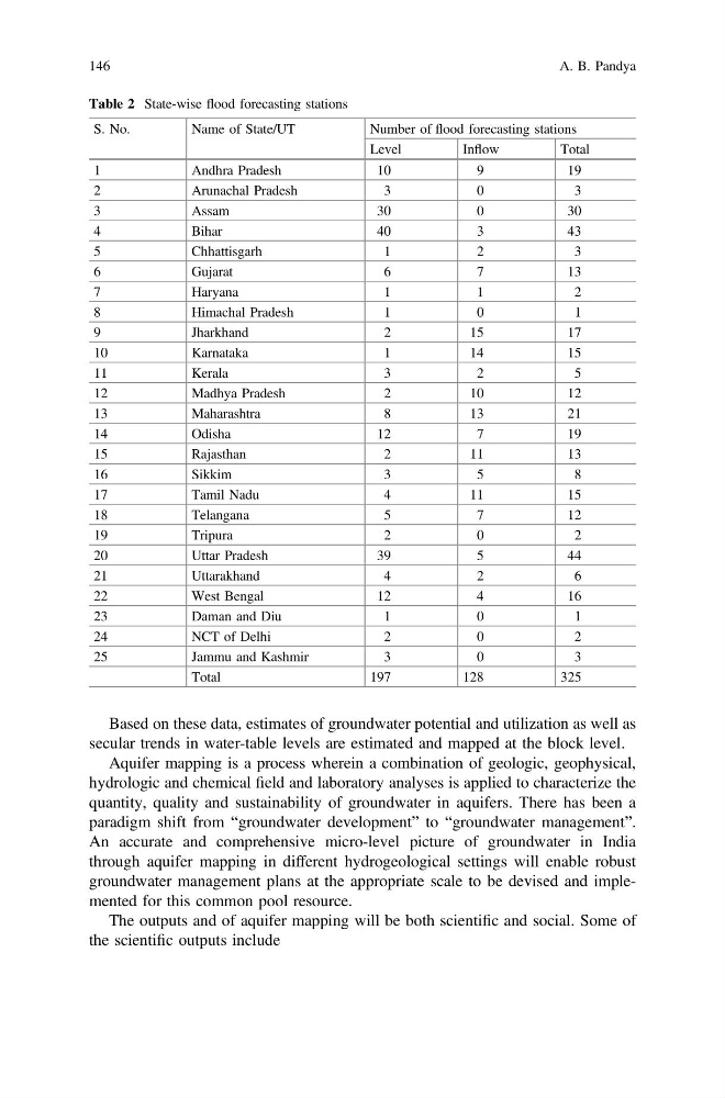
Table 2 State-wise flood forecasting stations
S. No.
Name of State/UT
Number of flood forecasting stations
Level
Inflow
Total
1
Andhra Pradesh
10
9
19
2
Arunachal Pradesh
3
0
3
3
Assam
30
0
30
4
Bihar
40
3
43
5
Chhattisgarh
1
2
3
6
Gujarat
6
7
13
7
Haryana
1
1
2
8
Himachal Pradesh
1
0
1
9
Jharkhand
2
15
17
10
Karnataka
1
14
15
11
Kerala
3
2
5
12
Madhya Pradesh
2
10
12
13
Maharashtra
8
13
21
14
Odisha
12
7
19
15
Rajasthan
2
11
13
16
Sikkim
3
5
8
17
Tamil Nadu
4
11
15
18
Telangana
5
7
12
19
Tripura
2
0
2
20
Uttar Pradesh
39
5
44
21
Uttarakhand
4
2
6
22
West Bengal
12
4
16
23
Daman and Diu
1
0
1
24
NCT of Delhi
2
0
2
25
Jammu and Kashmir
3
0
3
Total
197
128
325
146
A. B. Pandya
secular trends in water-table levels are estimated and mapped at the block level.
Aquifer mapping is a process wherein a combination of geologic, geophysical,
hydrologic and chemical field and laboratory analyses is applied to characterize the
quantity, quality and sustainability of groundwater in aquifers. There has been a
paradigm shift from “groundwater development” to “groundwater management”.
An accurate and comprehensive micro-level picture of groundwater in India
through aquifer mapping in different hydrogeological settings will enable robust
groundwater management plans at the appropriate scale to be devised and implemented for this common pool resource.
The outputs and of aquifer mapping will be both scientific and social. Some of
the scientific outputs include
Table 2 State-wise flood forecasting stations
S. No.
Name of State/UT
Number of flood forecasting stations
Level
Inflow
Total
1
Andhra Pradesh
10
9
19
2
Arunachal Pradesh
3
0
3
3
Assam
30
0
30
4
Bihar
40
3
43
5
Chhattisgarh
1
2
3
6
Gujarat
6
7
13
7
Haryana
1
1
2
8
Himachal Pradesh
1
0
1
9
Jharkhand
2
15
17
10
Karnataka
1
14
15
11
Kerala
3
2
5
12
Madhya Pradesh
2
10
12
13
Maharashtra
8
13
21
14
Odisha
12
7
19
15
Rajasthan
2
11
13
16
Sikkim
3
5
8
17
Tamil Nadu
4
11
15
18
Telangana
5
7
12
19
Tripura
2
0
2
20
Uttar Pradesh
39
5
44
21
Uttarakhand
4
2
6
22
West Bengal
12
4
16
23
Daman and Diu
1
0
1
24
NCT of Delhi
2
0
2
25
Jammu and Kashmir
3
0
3
Total
197
128
325
146
A. B. Pandya