

3.2 Groundwater Data
The CGWB is the principal agency responsible for assessment of groundwater
potential and its exploitation in the country, as well tracking trends in its utilization.
It has done a considerable amount work to develop, test and refine the conceptual
framework and estimation procedures for this purpose. It has assessed the volume
of renewable groundwater resources generated by direct recharge from rainfall and
indirectly on account of lateral seepage from rivers, streams, water bodies and
canals.
These estimates are based on field studies of recharge rates under different
agroclimatic and geological conditions. In addition, the CGWB (along with the
State Boards) monitors the behaviour of water levels in over 50,000 observation
wells across seasons and over the years. Studies on a more limited scale are being
done on the estimation of several other aspects (delineating and mapping of aquifer
disposition, specific yield, extraction rate and groundwater quality) relevant for
groundwater potential and use.
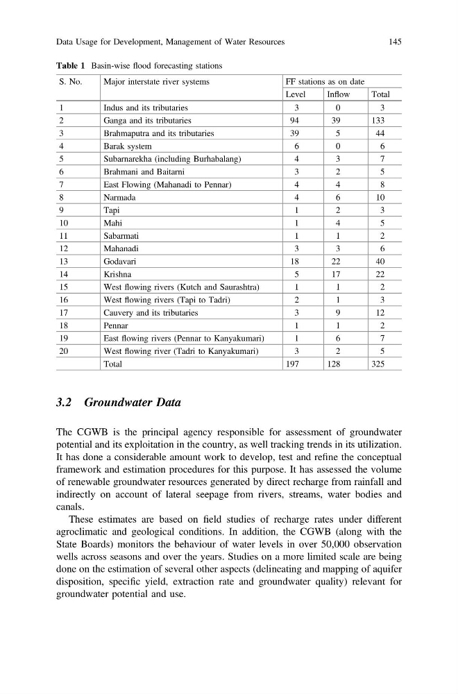
Table 1 Basin-wise flood forecasting stations
S. No.
Major interstate river systems
FF stations as on date
Level
Inflow
Total
1
Indus and its tributaries
3
0
3
2
Ganga and its tributaries
94
39
133
3
Brahmaputra and its tributaries
39
5
44
4
Barak system
6
0
6
5
Subarnarekha (including Burhabalang)
4
3
7
6
Brahmani and Baitarni
3
2
5
7
East Flowing (Mahanadi to Pennar)
4
4
8
8
Narmada
4
6
10
9
Tapi
1
2
3
10
Mahi
1
4
5
11
Sabarmati
1
1
2
12
Mahanadi
3
3
6
13
Godavari
18
22
40
14
Krishna
5
17
22
15
West flowing rivers (Kutch and Saurashtra)
1
1
2
16
West flowing rivers (Tapi to Tadri)
2
1
3
17
Cauvery and its tributaries
3
9
12
18
Pennar
1
1
2
19
East flowing rivers (Pennar to Kanyakumari)
1
6
7
20
West flowing river (Tadri to Kanyakumari)
3
2
5
Total
197
128
325
Data Usage for Development, Management of Water Resources
145
The CGWB is the principal agency responsible for assessment of groundwater
potential and its exploitation in the country, as well tracking trends in its utilization.
It has done a considerable amount work to develop, test and refine the conceptual
framework and estimation procedures for this purpose. It has assessed the volume
of renewable groundwater resources generated by direct recharge from rainfall and
indirectly on account of lateral seepage from rivers, streams, water bodies and
canals.
These estimates are based on field studies of recharge rates under different
agroclimatic and geological conditions. In addition, the CGWB (along with the
State Boards) monitors the behaviour of water levels in over 50,000 observation
wells across seasons and over the years. Studies on a more limited scale are being
done on the estimation of several other aspects (delineating and mapping of aquifer
disposition, specific yield, extraction rate and groundwater quality) relevant for
groundwater potential and use.
Table 1 Basin-wise flood forecasting stations
S. No.
Major interstate river systems
FF stations as on date
Level
Inflow
Total
1
Indus and its tributaries
3
0
3
2
Ganga and its tributaries
94
39
133
3
Brahmaputra and its tributaries
39
5
44
4
Barak system
6
0
6
5
Subarnarekha (including Burhabalang)
4
3
7
6
Brahmani and Baitarni
3
2
5
7
East Flowing (Mahanadi to Pennar)
4
4
8
8
Narmada
4
6
10
9
Tapi
1
2
3
10
Mahi
1
4
5
11
Sabarmati
1
1
2
12
Mahanadi
3
3
6
13
Godavari
18
22
40
14
Krishna
5
17
22
15
West flowing rivers (Kutch and Saurashtra)
1
1
2
16
West flowing rivers (Tapi to Tadri)
2
1
3
17
Cauvery and its tributaries
3
9
12
18
Pennar
1
1
2
19
East flowing rivers (Pennar to Kanyakumari)
1
6
7
20
West flowing river (Tadri to Kanyakumari)
3
2
5
Total
197
128
325
Data Usage for Development, Management of Water Resources
145