

The start of acacia plantations at the end of the 1990s saw an inflow of migrants
from North Sumatra. Javanese went into the village partly through the road and the
canal that was built by companies. Migrants from North Sumatra looked for forest
with soil that was not peatland, and they found some that was covered in mineral
soil. But this area was limited, so people were forced to cultivate peatland as well,
which they mainly planted with oil palm. They settled in the southern part of the
survey area in 1999, around 15 km from the coast within the state forest area.
The rapid expansion of oil palm cultivation in peatlands accelerated peatland
degradation. Fires became a common occurrence, and because of the frequent fires,
the area covered by immature oil palm trees of under 3 years was far more extensive
than the area of the productive oil palm trees. Oil palm trees were lost in fires before
they matured and were productive; hence large areas of unproductive oil palm were
found.
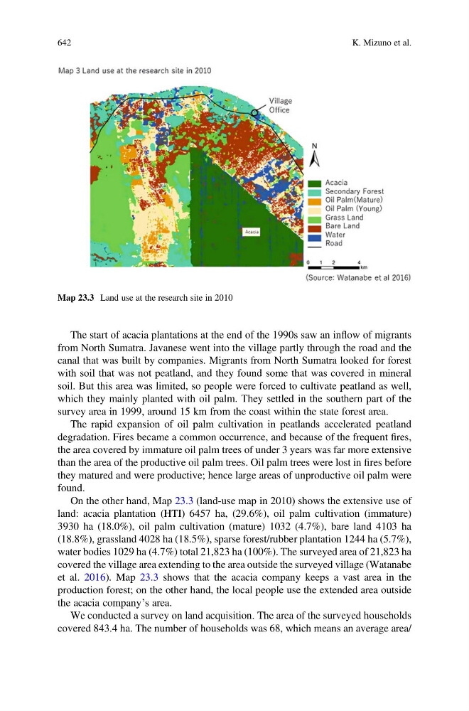
On the other hand, Map 23.3 (land-use map in 2010) shows the extensive use of
land: acacia plantation (HTI) 6457 ha, (29.6%), oil palm cultivation (immature)
3930 ha (18.0%), oil palm cultivation (mature) 1032 (4.7%), bare land 4103 ha
(18.8%), grassland 4028 ha (18.5%), sparse forest/rubber plantation 1244 ha (5.7%),
water bodies 1029 ha (4.7%) total 21,823 ha (100%). The surveyed area of 21,823 ha
covered the village area extending to the area outside the surveyed village (Watanabe
et al. 2016). Map 23.3 shows that the acacia company keeps a vast area in the
production forest; on the other hand, the local people use the extended area outside
the acacia company’s area.
We conducted a survey on land acquisition. The area of the surveyed households
covered 843.4 ha. The number of households was 68, which means an average area/
Map 23.3 Land use at the research site in 2010
642
K. Mizuno et al.