

established to monitor the groundwater tables and around six water meters were
installed to measure and monitor the surface water fluctuation on the downstream
and upstream sides of both of the canals. The data were collected in September–
December 2018 to capture the hydrological dynamics of dry, transitional, and rainy
seasons.
20.4.2 Study Site and Method
20.4.2.1 Study Site
The study site was at Garung village, Pulang Pisau District of Central Kalimantan,
Indonesia. The village is located at the Kapuas-Kahayan peatland hydrological unit.
The study site experienced devastating fire in 2015 and has been assigned as a
priority target for peatland restoration by Peatland Restoration Agency (BRG).
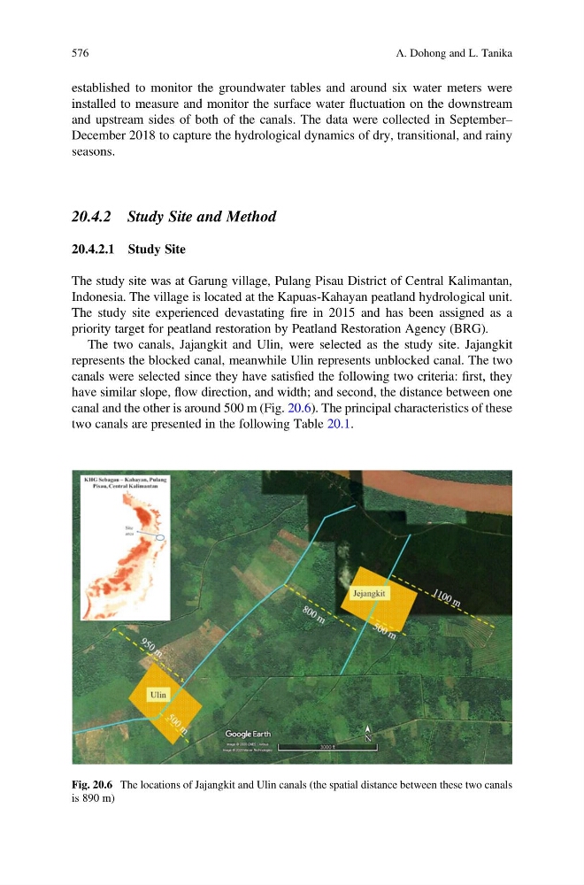
The two canals, Jajangkit and Ulin, were selected as the study site. Jajangkit
represents the blocked canal, meanwhile Ulin represents unblocked canal. The two
canals were selected since they have satisfied the following two criteria: first, they
have similar slope, flow direction, and width; and second, the distance between one
canal and the other is around 500 m (Fig. 20.6). The principal characteristics of these
two canals are presented in the following Table 20.1.
Fig. 20.6 The locations of Jajangkit and Ulin canals (the spatial distance between these two canals
is 890 m)
576
A. Dohong and L. Tanika
installed to measure and monitor the surface water fluctuation on the downstream
and upstream sides of both of the canals. The data were collected in September–
December 2018 to capture the hydrological dynamics of dry, transitional, and rainy
seasons.
20.4.2 Study Site and Method
20.4.2.1 Study Site
The study site was at Garung village, Pulang Pisau District of Central Kalimantan,
Indonesia. The village is located at the Kapuas-Kahayan peatland hydrological unit.
The study site experienced devastating fire in 2015 and has been assigned as a
priority target for peatland restoration by Peatland Restoration Agency (BRG).
The two canals, Jajangkit and Ulin, were selected as the study site. Jajangkit
represents the blocked canal, meanwhile Ulin represents unblocked canal. The two
canals were selected since they have satisfied the following two criteria: first, they
have similar slope, flow direction, and width; and second, the distance between one
canal and the other is around 500 m (Fig. 20.6). The principal characteristics of these
two canals are presented in the following Table 20.1.
Fig. 20.6 The locations of Jajangkit and Ulin canals (the spatial distance between these two canals
is 890 m)
576
A. Dohong and L. Tanika