

13.2 Katingan-Mentaya Project Profile
13.2.1 Climate and Geographic Setting
The estimated coverage of peatlands in Central Kalimantan is around three million
hectare (Wahyunto and Suprapto 2005) or about 20% of the total area of this
province. Most of them are located in the lowland in the southern part of Central
Kalimantan, spreading in Barito Selatan, Barito Timur, Kahayan Hilir, Kapuas,
Katingan, Kotawaringin Timur, Kotawaringin Barat, Seruyan, and Sukamara Districts. KMP is flanked by two watershed systems, the Mentaya River watershed at
the west (Kotawaringin Timur District) and the Katingan River watershed at the east
(Katingan District).
The geographical boundaries of the area are S2
03' 53.32" to S3
01
0 43.6
00 and
E113
00
0 29.7
00 to E113
18
0 57.4
00 . As located in the tropical climate zone, KMP is
influenced by the intertropical convergence zone (ITCZ), causing the monsoonal
rainfall pattern. When ITCZ is below the equator line in October–March and on the
north equator in April–September, wet and dry seasons, respectively, might occur in
the KMP area. The annual mean temperature is 25.9
C with the minimum temperature 17.7
C and the maximum temperature 35.3
C.
Meteorological data such as precipitation, air temperature, wind, and relative
humidity within the area are recorded from local mini weather stations installed
inside KMP-PA. In relation to the water table measurement, around 31 automatic
water loggers have been installed across KMP-PA, 22 of which is HOBO™. Up to
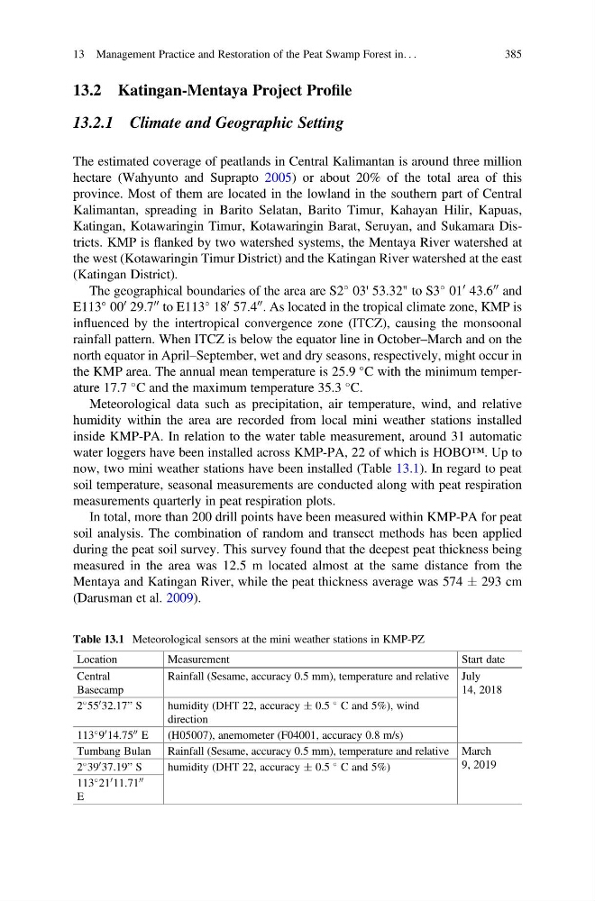
now, two mini weather stations have been installed (Table 13.1). In regard to peat
soil temperature, seasonal measurements are conducted along with peat respiration
measurements quarterly in peat respiration plots.
In total, more than 200 drill points have been measured within KMP-PA for peat
soil analysis. The combination of random and transect methods has been applied
during the peat soil survey. This survey found that the deepest peat thickness being
measured in the area was 12.5 m located almost at the same distance from the
Mentaya and Katingan River, while the peat thickness average was 574 Æ 293 cm
(Darusman et al. 2009).
Table 13.1 Meteorological sensors at the mini weather stations in KMP-PZ
Location
Measurement
Start date
Central
Basecamp
Rainfall (Sesame, accuracy 0.5 mm), temperature and relative July
14, 2018
2
55
0 32.17” S
humidity (DHT 22, accuracy Æ 0.5
C and 5%), wind
direction
113
9
0 14.75
00 E
(H05007), anemometer (F04001, accuracy 0.8 m/s)
Tumbang Bulan Rainfall (Sesame, accuracy 0.5 mm), temperature and relative March
9, 2019
2
39
0 37.19” S
humidity (DHT 22, accuracy Æ 0.5
C and 5%)
113
21
0 11.71
00
E
13 Management Practice and Restoration of the Peat Swamp Forest in. . .
385
13.2.1 Climate and Geographic Setting
The estimated coverage of peatlands in Central Kalimantan is around three million
hectare (Wahyunto and Suprapto 2005) or about 20% of the total area of this
province. Most of them are located in the lowland in the southern part of Central
Kalimantan, spreading in Barito Selatan, Barito Timur, Kahayan Hilir, Kapuas,
Katingan, Kotawaringin Timur, Kotawaringin Barat, Seruyan, and Sukamara Districts. KMP is flanked by two watershed systems, the Mentaya River watershed at
the west (Kotawaringin Timur District) and the Katingan River watershed at the east
(Katingan District).
The geographical boundaries of the area are S2
03' 53.32" to S3
01
0 43.6
00 and
E113
00
0 29.7
00 to E113
18
0 57.4
00 . As located in the tropical climate zone, KMP is
influenced by the intertropical convergence zone (ITCZ), causing the monsoonal
rainfall pattern. When ITCZ is below the equator line in October–March and on the
north equator in April–September, wet and dry seasons, respectively, might occur in
the KMP area. The annual mean temperature is 25.9
C with the minimum temperature 17.7
C and the maximum temperature 35.3
C.
Meteorological data such as precipitation, air temperature, wind, and relative
humidity within the area are recorded from local mini weather stations installed
inside KMP-PA. In relation to the water table measurement, around 31 automatic
water loggers have been installed across KMP-PA, 22 of which is HOBO™. Up to
now, two mini weather stations have been installed (Table 13.1). In regard to peat
soil temperature, seasonal measurements are conducted along with peat respiration
measurements quarterly in peat respiration plots.
In total, more than 200 drill points have been measured within KMP-PA for peat
soil analysis. The combination of random and transect methods has been applied
during the peat soil survey. This survey found that the deepest peat thickness being
measured in the area was 12.5 m located almost at the same distance from the
Mentaya and Katingan River, while the peat thickness average was 574 Æ 293 cm
(Darusman et al. 2009).
Table 13.1 Meteorological sensors at the mini weather stations in KMP-PZ
Location
Measurement
Start date
Central
Basecamp
Rainfall (Sesame, accuracy 0.5 mm), temperature and relative July
14, 2018
2
55
0 32.17” S
humidity (DHT 22, accuracy Æ 0.5
C and 5%), wind
direction
113
9
0 14.75
00 E
(H05007), anemometer (F04001, accuracy 0.8 m/s)
Tumbang Bulan Rainfall (Sesame, accuracy 0.5 mm), temperature and relative March
9, 2019
2
39
0 37.19” S
humidity (DHT 22, accuracy Æ 0.5
C and 5%)
113
21
0 11.71
00
E
13 Management Practice and Restoration of the Peat Swamp Forest in. . .
385