

In the future, hyperspectral sensors are expected to supply more detailed information
with high spectral resolution for mapping and assessment of the peatland ecosystems
(Hirose et al. 2016). Moreover, this method is expected to contribute to measurement
of the nationally determined contributions (NDCs) of the Paris Agreement to
mitigate carbon dioxide emissions from peatlands in the Amazon and to the policy
on natural resource conservation programs.
5.6.5 International Equator Observation Sensing (iEOS)
Network
Figure 5.15 shows a map of the global annual afternoon cloudiness between 2002
and 2015 (https://eclipsophile.com/global-cloud-cover/), which indicates that the
tropical zone is covered by heavy clouds. Therefore, it is difficult to obtain an optical
sensor scene from the satellite. We propose the iEOS network for construction of
mosaic one scene GIS by collecting GIS data from cloudless space.
Sensing System at the Equator As technology advances, the integrated MRV
sensors will be able to be loaded into UAVs (commonly known as drones), balloons,
and microsatellites in order of covering scale, larger in this turn (Fig. 5.16). Specifically, UAVs are constantly improved and used in a variety of fields, not only in
agriculture and forestry, and are attracting much attention. Although drones sold to
consumers have flight time and payload issues, the technology might be improved in
the future to allow relatively inexpensive and accurate observations over a specific
area. However, at the moment, the best approach is to use a UAV, balloon, and
microsatellite depending on the purpose and scale of the observation.
As mentioned above, the existing MRV systems were based on optical sensors.
Eventually, integration of SAR (synthetic aperture radar) radar sensors into the
optical MRV system might result in a truly “integrated MRV system,” which is
0.00
0.05
0.10
0.15
0.20
0.25
0.30
0.35
0.40
0.45
0.50
B2
B3
B4
B5
B6
B7
B8A
B11
B12
REFLECTANCE
SENTINEL-2/BANDS (2019/09/26)
Aguaje
Mixed-Wetland-Forest
Upland-Forest
Upland-Forest_Mountain
Grass
Rice
0.00
0.05
0.10
0.15
0.20
0.25
0.30
0.35
0.40
0.45
0.50
B1
B2
B3
B4
B5
B6
B7
REFLECTANCE
Landsat-8/Bands (2016/11/22)
Aguaje
Mixed-Wetland-Forest
Upland-Forest
Upland-Forest_Mountain
Grass
Rice
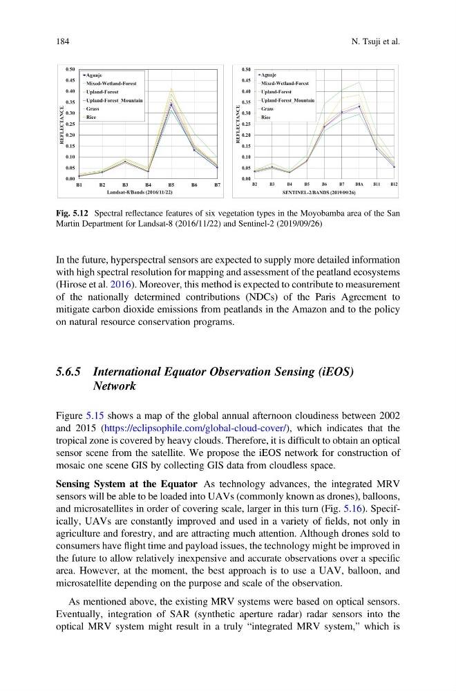
Fig. 5.12 Spectral reflectance features of six vegetation types in the Moyobamba area of the San
Martin Department for Landsat-8 (2016/11/22) and Sentinel-2 (2019/09/26)
184
N. Tsuji et al.
with high spectral resolution for mapping and assessment of the peatland ecosystems
(Hirose et al. 2016). Moreover, this method is expected to contribute to measurement
of the nationally determined contributions (NDCs) of the Paris Agreement to
mitigate carbon dioxide emissions from peatlands in the Amazon and to the policy
on natural resource conservation programs.
5.6.5 International Equator Observation Sensing (iEOS)
Network
Figure 5.15 shows a map of the global annual afternoon cloudiness between 2002
and 2015 (https://eclipsophile.com/global-cloud-cover/), which indicates that the
tropical zone is covered by heavy clouds. Therefore, it is difficult to obtain an optical
sensor scene from the satellite. We propose the iEOS network for construction of
mosaic one scene GIS by collecting GIS data from cloudless space.
Sensing System at the Equator As technology advances, the integrated MRV
sensors will be able to be loaded into UAVs (commonly known as drones), balloons,
and microsatellites in order of covering scale, larger in this turn (Fig. 5.16). Specifically, UAVs are constantly improved and used in a variety of fields, not only in
agriculture and forestry, and are attracting much attention. Although drones sold to
consumers have flight time and payload issues, the technology might be improved in
the future to allow relatively inexpensive and accurate observations over a specific
area. However, at the moment, the best approach is to use a UAV, balloon, and
microsatellite depending on the purpose and scale of the observation.
As mentioned above, the existing MRV systems were based on optical sensors.
Eventually, integration of SAR (synthetic aperture radar) radar sensors into the
optical MRV system might result in a truly “integrated MRV system,” which is
0.00
0.05
0.10
0.15
0.20
0.25
0.30
0.35
0.40
0.45
0.50
B2
B3
B4
B5
B6
B7
B8A
B11
B12
REFLECTANCE
SENTINEL-2/BANDS (2019/09/26)
Aguaje
Mixed-Wetland-Forest
Upland-Forest
Upland-Forest_Mountain
Grass
Rice
0.00
0.05
0.10
0.15
0.20
0.25
0.30
0.35
0.40
0.45
0.50
B1
B2
B3
B4
B5
B6
B7
REFLECTANCE
Landsat-8/Bands (2016/11/22)
Aguaje
Mixed-Wetland-Forest
Upland-Forest
Upland-Forest_Mountain
Grass
Rice
Fig. 5.12 Spectral reflectance features of six vegetation types in the Moyobamba area of the San
Martin Department for Landsat-8 (2016/11/22) and Sentinel-2 (2019/09/26)
184
N. Tsuji et al.