

operation of eco-management in a large-scale ecosystem of tropical peatland with a
stock-based WM system. These functions include the following:
1. Design and development of the stock-based WM according to the detailed
topographic and peat information
2. Management of water balance and GWL under climate change impacts
3. Estimation of biomass production
4. Estimation of carbon emission (peatland degradation by microorganisms and fire)
5. Certification support for reduction of emission from deforestation and forest
degradation + (REDD+), forest services, and wildlife conservation
6. Monitoring of wildlife and human activity
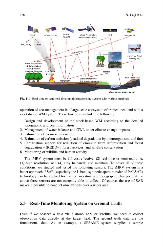
The iMRV system must be (1) cost-effective, (2) real-time or semi-real-time,
(3) high resolution, and (4) easy to handle and maintain. To cover all of these
conditions, we studied and tested the following sensors. The iMRV system is a
better approach if SAR (especially the L-band synthetic aperture radar of PALSAR)
technology can be applied for the soil moisture and topographic changes that the
above three sensors are not currently able to collect. Of course, the use of SAR
makes it possible to conduct observations over a wider area.
5.3 Real-Time Monitoring System on Ground Truth
Even if we observe a field via a drone/UAV or satellite, we need to collect
observation data directly at the target field. The ground truth data are the
foundational data. As an example, a SESAME system supplies a simple
G GOSAT
Peat fire &
peat loss
Topography
Peat subsidence
Water soluble organic carbon
CO 2 & CH 4
Haze
MODIS, Landsat
Unmanned Aerial
Vehicle (UAV)
Global Precipitation
Measurement (GPM)
SESAME III
• Groundwater Level
• Soil Moisture Content
Forest Degradation
& Deforestation
(REED), Species
mapping, Biomass
PALSAR,
PALSAR2
HISUI
Microsatellite
Fig. 5.1 Real-time or semi real-time monitoring/sensing system with various methods
166
N. Tsuji et al.
stock-based WM system. These functions include the following:
1. Design and development of the stock-based WM according to the detailed
topographic and peat information
2. Management of water balance and GWL under climate change impacts
3. Estimation of biomass production
4. Estimation of carbon emission (peatland degradation by microorganisms and fire)
5. Certification support for reduction of emission from deforestation and forest
degradation + (REDD+), forest services, and wildlife conservation
6. Monitoring of wildlife and human activity
The iMRV system must be (1) cost-effective, (2) real-time or semi-real-time,
(3) high resolution, and (4) easy to handle and maintain. To cover all of these
conditions, we studied and tested the following sensors. The iMRV system is a
better approach if SAR (especially the L-band synthetic aperture radar of PALSAR)
technology can be applied for the soil moisture and topographic changes that the
above three sensors are not currently able to collect. Of course, the use of SAR
makes it possible to conduct observations over a wider area.
5.3 Real-Time Monitoring System on Ground Truth
Even if we observe a field via a drone/UAV or satellite, we need to collect
observation data directly at the target field. The ground truth data are the
foundational data. As an example, a SESAME system supplies a simple
G GOSAT
Peat fire &
peat loss
Topography
Peat subsidence
Water soluble organic carbon
CO 2 & CH 4
Haze
MODIS, Landsat
Unmanned Aerial
Vehicle (UAV)
Global Precipitation
Measurement (GPM)
SESAME III
• Groundwater Level
• Soil Moisture Content
Forest Degradation
& Deforestation
(REED), Species
mapping, Biomass
PALSAR,
PALSAR2
HISUI
Microsatellite
Fig. 5.1 Real-time or semi real-time monitoring/sensing system with various methods
166
N. Tsuji et al.