

plan should focus on minimizing the number of infrastructures as well as properly
managing the GWL throughout the target area.
Many existing peat development sites have been constructed with a network of
canals that ignore the contour lines. Hence, any improvements to peatland management should be carefully considered to ensure that a minimum number of infrastructures are developed after a detailed topographic map has been prepared. Many
business owners believe that improving peatland management will be expensive
and result in a loss of productivity, and as a result, the improvements will not go
anywhere.
When WSL-MTI developed the plan, the LiDAR and UAV technology was not
as common as it is today. Therefore, it took 5 years and a huge amount of money to
perform the survey manually, but now with UAVs, it can be accomplished at a lower
cost. Similarly, infrastructure can be built with simple structures and a low cost.
Main Road Construction The main road is usually along with the main canal. The
main function of the main road is to transport not only wood logs to the jetty but also
heavy equipment, laborers, seedlings, and materials.
Main Canal Construction The main canal with a width of 10–12 m and a depth of
3 m is constructed from the lower to the near upper area. From the air, the main canal
is like the backbone of an animal body. Peat dams should completely block the main
canal to avoid water flow from upstream. Spillways adjust the water level of the main
canal.
Branch Canal Construction Branch canals are 6–8 m in width and 3 m in depth.
The branch canals are connected to the main canal at a right angle and should be
constructed along with the contour line and never cross the contour line to avoid
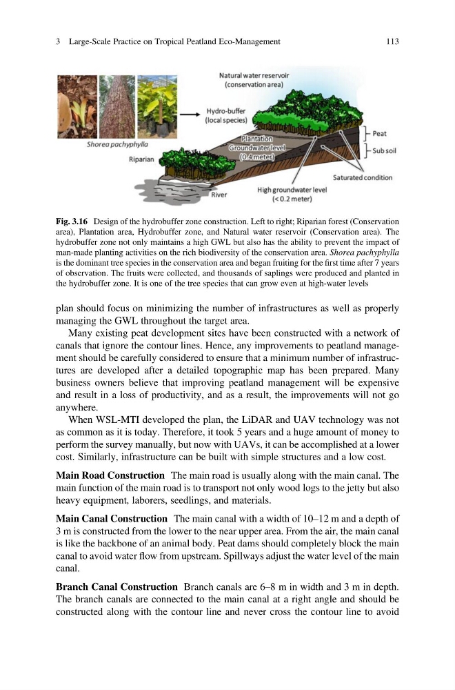
Fig. 3.16 Design of the hydrobuffer zone construction. Left to right; Riparian forest (Conservation
area), Plantation area, Hydrobuffer zone, and Natural water reservoir (Conservation area). The
hydrobuffer zone not only maintains a high GWL but also has the ability to prevent the impact of
man-made planting activities on the rich biodiversity of the conservation area. Shorea pachyphylla
is the dominant tree species in the conservation area and began fruiting for the first time after 7 years
of observation. The fruits were collected, and thousands of saplings were produced and planted in
the hydrobuffer zone. It is one of the tree species that can grow even at high-water levels
3 Large-Scale Practice on Tropical Peatland Eco-Management
113
managing the GWL throughout the target area.
Many existing peat development sites have been constructed with a network of
canals that ignore the contour lines. Hence, any improvements to peatland management should be carefully considered to ensure that a minimum number of infrastructures are developed after a detailed topographic map has been prepared. Many
business owners believe that improving peatland management will be expensive
and result in a loss of productivity, and as a result, the improvements will not go
anywhere.
When WSL-MTI developed the plan, the LiDAR and UAV technology was not
as common as it is today. Therefore, it took 5 years and a huge amount of money to
perform the survey manually, but now with UAVs, it can be accomplished at a lower
cost. Similarly, infrastructure can be built with simple structures and a low cost.
Main Road Construction The main road is usually along with the main canal. The
main function of the main road is to transport not only wood logs to the jetty but also
heavy equipment, laborers, seedlings, and materials.
Main Canal Construction The main canal with a width of 10–12 m and a depth of
3 m is constructed from the lower to the near upper area. From the air, the main canal
is like the backbone of an animal body. Peat dams should completely block the main
canal to avoid water flow from upstream. Spillways adjust the water level of the main
canal.
Branch Canal Construction Branch canals are 6–8 m in width and 3 m in depth.
The branch canals are connected to the main canal at a right angle and should be
constructed along with the contour line and never cross the contour line to avoid
Fig. 3.16 Design of the hydrobuffer zone construction. Left to right; Riparian forest (Conservation
area), Plantation area, Hydrobuffer zone, and Natural water reservoir (Conservation area). The
hydrobuffer zone not only maintains a high GWL but also has the ability to prevent the impact of
man-made planting activities on the rich biodiversity of the conservation area. Shorea pachyphylla
is the dominant tree species in the conservation area and began fruiting for the first time after 7 years
of observation. The fruits were collected, and thousands of saplings were produced and planted in
the hydrobuffer zone. It is one of the tree species that can grow even at high-water levels
3 Large-Scale Practice on Tropical Peatland Eco-Management
113