

“Landscape map of Altai Krai” (Tsimbaley 2011)
of 1:500,000 scale as well as topographical maps
of 1:200,000 scale serve as a basic cartographic
material processed in ArcGIS 9.2 to create digital
versions of the maps. Landscape morphometry
was calculated with TIN models constructed by
3D Analyst extension of ArcGIS.
The general climatic characteristics of the
Altai-Sayan Mountains according to data from
weather stations (Table 7.2) show that most of
annual precipitation falls on the warm period
lasted about half a year. In SAM, we use the
long-term monthly dynamics of air temperature
and precipitation, which are normalized and
spatially generalized.
The created database to execute SAM of river
water quality includes the following characteristics: hydrological (5300 normalized seasonal
average values of streamflow for 34 selected
river basins and four seasons for each year of the
period 1951–2003), hydrochemical (1200–2000
seasonal average concentrations for each of
seven analytes), meteorological (636 + 636 =
1272 normalized monthly values of air temperature and precipitation for 1951–2003 with the
resulting 1272/4 = 318 seasonal values), and
cartographic (the area and average altitude of
each landscape in each basin, the area of arable
land, lateral slope of the basin and altitude of its
outlet, river length from source to outlet).
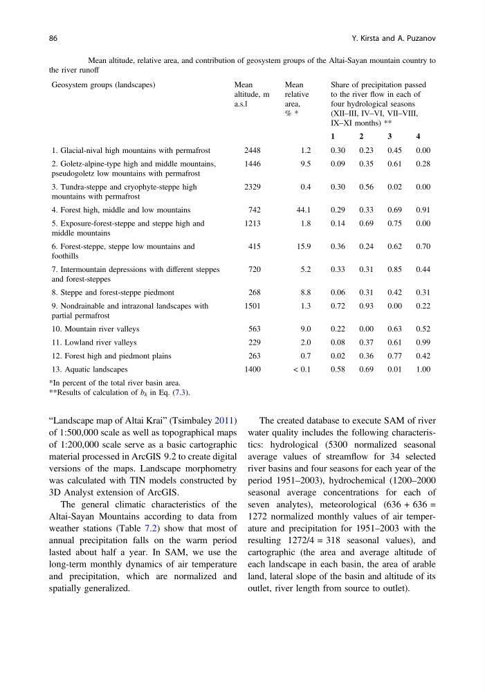
Table 7.1 Mean altitude, relative area, and contribution of geosystem groups of the Altai-Sayan mountain country to
the river runoff
Geosystem groups (landscapes)
Mean
altitude, m
a.s.l
Mean
relative
area,
% *
Share of precipitation passed
to the river flow in each of
four hydrological seasons
(XII–III, IV–VI, VII–VIII,
IX–XI months) **
1
2
3
4
1. Glacial-nival high mountains with permafrost
2448
1.2
0.30
0.23
0.45
0.00
2. Goletz-alpine-type high and middle mountains,
pseudogoletz low mountains with permafrost
1446
9.5
0.09
0.35
0.61
0.28
3. Tundra-steppe and cryophyte-steppe high
mountains with permafrost
2329
0.4
0.30
0.56
0.02
0.00
4. Forest high, middle and low mountains
742
44.1
0.29
0.33
0.69
0.91
5. Exposure-forest-steppe and steppe high and
middle mountains
1213
1.8
0.14
0.69
0.75
0.00
6. Forest-steppe, steppe low mountains and
foothills
415
15.9
0.36
0.24
0.62
0.70
7. Intermountain depressions with different steppes
and forest-steppes
720
5.2
0.33
0.31
0.85
0.44
8. Steppe and forest-steppe piedmont
268
8.8
0.06
0.31
0.42
0.31
9. Nondrainable and intrazonal landscapes with
partial permafrost
1501
1.3
0.72
0.93
0.00
0.22
10. Mountain river valleys
563
9.0
0.22
0.00
0.63
0.52
11. Lowland river valleys
229
2.0
0.08
0.37
0.61
0.99
12. Forest high and piedmont plains
263
0.7
0.02
0.36
0.77
0.42
13. Aquatic landscapes
1400
< 0.1
0.58
0.69
0.01
1.00
*In percent of the total river basin area.
**Results of calculation of b k in Eq. (7.3).
86
Y. Kirsta and A. Puzanov
of 1:500,000 scale as well as topographical maps
of 1:200,000 scale serve as a basic cartographic
material processed in ArcGIS 9.2 to create digital
versions of the maps. Landscape morphometry
was calculated with TIN models constructed by
3D Analyst extension of ArcGIS.
The general climatic characteristics of the
Altai-Sayan Mountains according to data from
weather stations (Table 7.2) show that most of
annual precipitation falls on the warm period
lasted about half a year. In SAM, we use the
long-term monthly dynamics of air temperature
and precipitation, which are normalized and
spatially generalized.
The created database to execute SAM of river
water quality includes the following characteristics: hydrological (5300 normalized seasonal
average values of streamflow for 34 selected
river basins and four seasons for each year of the
period 1951–2003), hydrochemical (1200–2000
seasonal average concentrations for each of
seven analytes), meteorological (636 + 636 =
1272 normalized monthly values of air temperature and precipitation for 1951–2003 with the
resulting 1272/4 = 318 seasonal values), and
cartographic (the area and average altitude of
each landscape in each basin, the area of arable
land, lateral slope of the basin and altitude of its
outlet, river length from source to outlet).
Table 7.1 Mean altitude, relative area, and contribution of geosystem groups of the Altai-Sayan mountain country to
the river runoff
Geosystem groups (landscapes)
Mean
altitude, m
a.s.l
Mean
relative
area,
% *
Share of precipitation passed
to the river flow in each of
four hydrological seasons
(XII–III, IV–VI, VII–VIII,
IX–XI months) **
1
2
3
4
1. Glacial-nival high mountains with permafrost
2448
1.2
0.30
0.23
0.45
0.00
2. Goletz-alpine-type high and middle mountains,
pseudogoletz low mountains with permafrost
1446
9.5
0.09
0.35
0.61
0.28
3. Tundra-steppe and cryophyte-steppe high
mountains with permafrost
2329
0.4
0.30
0.56
0.02
0.00
4. Forest high, middle and low mountains
742
44.1
0.29
0.33
0.69
0.91
5. Exposure-forest-steppe and steppe high and
middle mountains
1213
1.8
0.14
0.69
0.75
0.00
6. Forest-steppe, steppe low mountains and
foothills
415
15.9
0.36
0.24
0.62
0.70
7. Intermountain depressions with different steppes
and forest-steppes
720
5.2
0.33
0.31
0.85
0.44
8. Steppe and forest-steppe piedmont
268
8.8
0.06
0.31
0.42
0.31
9. Nondrainable and intrazonal landscapes with
partial permafrost
1501
1.3
0.72
0.93
0.00
0.22
10. Mountain river valleys
563
9.0
0.22
0.00
0.63
0.52
11. Lowland river valleys
229
2.0
0.08
0.37
0.61
0.99
12. Forest high and piedmont plains
263
0.7
0.02
0.36
0.77
0.42
13. Aquatic landscapes
1400
< 0.1
0.58
0.69
0.01
1.00
*In percent of the total river basin area.
**Results of calculation of b k in Eq. (7.3).
86
Y. Kirsta and A. Puzanov