

mitigate flood hazards. Their aim was to achieve
at least one of the following objectives:
• A reduction in the area flooded
• A reduction in the depth of floodwater
• A reduction in flood discharge
Flood in Darakeswar–Mundeswari Interfluve
is a recurrent problem. So, it cannot be avoided,
but the magnitude of its impact on life and
property can definitely be mitigated through
proper management measures. The suggested
structural measures are as follows.
1. River Channel Improvement
The primary consideration of the planner of
the Damodar Valley Scheme (DVS) was to provide adequate protection to the left embankment
along the Damodar River which protects the
arterial railway line, Grand Trunk Road (present
name Shersha Suri Road), industrial establishment etc. by restricting the flows at Durgapur
Barrage to 250,000 cusec (7079 cumec), which
was considered to be the safe maximum carrying
capacity of lower Damodar channel. The carrying capacity of lower reaches of the river below
Damodar barrage, later, diminished due to heavy
siltation. In some places, it has reduced to even
about 50,000 cusec. The lockage of tidal channels at outfalls, further adds to the flood problem
of the area.
The State Government has now commenced
implementation of a scheme: ‘Improvement of
drainage of lower Damodar to increase the
capacity of the channel’. The left bank embankment has also been strengthened to withstand a
controlled flow up to 450,000 cusec (12,743
cumec). The moderate flow from the dams was
planned also to prevent excessive flooding in the
fertile agricultural land on the right bank of
Damodar in this region. However, in the absence
of frequent floods of higher intensities and due to
low releases of less than 100,000 cusec (2,832
cumec) from the dams during the monsoon period, the lower valley has gained undue value and
importance due to false sense of security and
there has been extensive encroachment into the
floodplains. The Government of West Bengal
Table 6.4 Damage of embankment in three major floods
Year
Khanakul-I (km)
Khanakul-II (km)
Arambagh (km)
Pursurah (km)
Total (km)
2006
27
18
20
12
77
2007
23
13
16
8
60
2009
35
29
58
19
141
Source Disaster Management Department, Arambagh, Hugli, 2010
0
50
100
150
200
250
300
Khanakul-IKhanakul-IIArambagh Pursurah
Total
Length of embankment in Km.
Blocks
Damage of Embankment in three Major Floods (2006,
2007 and 2009)
2009
2007
2006
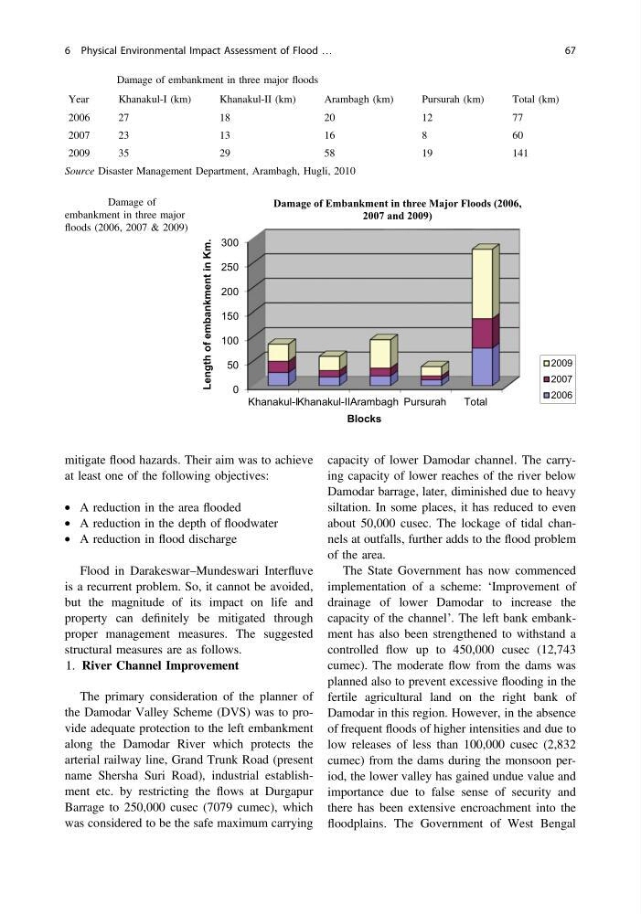
Fig. 6.7 Damage of
embankment in three major
floods (2006, 2007 & 2009)
6 Physical Environmental Impact Assessment of Flood …
67
at least one of the following objectives:
• A reduction in the area flooded
• A reduction in the depth of floodwater
• A reduction in flood discharge
Flood in Darakeswar–Mundeswari Interfluve
is a recurrent problem. So, it cannot be avoided,
but the magnitude of its impact on life and
property can definitely be mitigated through
proper management measures. The suggested
structural measures are as follows.
1. River Channel Improvement
The primary consideration of the planner of
the Damodar Valley Scheme (DVS) was to provide adequate protection to the left embankment
along the Damodar River which protects the
arterial railway line, Grand Trunk Road (present
name Shersha Suri Road), industrial establishment etc. by restricting the flows at Durgapur
Barrage to 250,000 cusec (7079 cumec), which
was considered to be the safe maximum carrying
capacity of lower Damodar channel. The carrying capacity of lower reaches of the river below
Damodar barrage, later, diminished due to heavy
siltation. In some places, it has reduced to even
about 50,000 cusec. The lockage of tidal channels at outfalls, further adds to the flood problem
of the area.
The State Government has now commenced
implementation of a scheme: ‘Improvement of
drainage of lower Damodar to increase the
capacity of the channel’. The left bank embankment has also been strengthened to withstand a
controlled flow up to 450,000 cusec (12,743
cumec). The moderate flow from the dams was
planned also to prevent excessive flooding in the
fertile agricultural land on the right bank of
Damodar in this region. However, in the absence
of frequent floods of higher intensities and due to
low releases of less than 100,000 cusec (2,832
cumec) from the dams during the monsoon period, the lower valley has gained undue value and
importance due to false sense of security and
there has been extensive encroachment into the
floodplains. The Government of West Bengal
Table 6.4 Damage of embankment in three major floods
Year
Khanakul-I (km)
Khanakul-II (km)
Arambagh (km)
Pursurah (km)
Total (km)
2006
27
18
20
12
77
2007
23
13
16
8
60
2009
35
29
58
19
141
Source Disaster Management Department, Arambagh, Hugli, 2010
0
50
100
150
200
250
300
Khanakul-IKhanakul-IIArambagh Pursurah
Total
Length of embankment in Km.
Blocks
Damage of Embankment in three Major Floods (2006,
2007 and 2009)
2009
2007
2006
Fig. 6.7 Damage of
embankment in three major
floods (2006, 2007 & 2009)
6 Physical Environmental Impact Assessment of Flood …
67