

that about 90% of the Sand varies in grain size
from 0.1 mm to 1 m. The grain size of Sand
became coarser near breaching place of
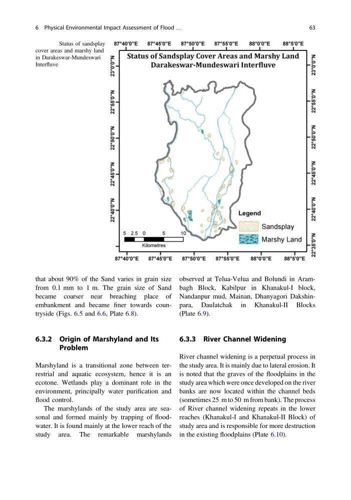
embankment and became finer towards countryside (Figs. 6.5 and 6.6, Plate 6.8).
6.3.2 Origin of Marshyland and Its
Problem
Marshyland is a transitional zone between terrestrial and aquatic ecosystem, hence it is an
ecotone. Wetlands play a dominant role in the
environment, principally water purification and
flood control.
The marshylands of the study area are seasonal and formed mainly by trapping of floodwater. It is found mainly at the lower reach of the
study area. The remarkable marshylands
observed at Telua-Velua and Bolundi in Arambagh Block, Kabilpur in Khanakul-I block,
Nandanpur mud, Mainan, Dhanyagori Dakshinpara, Daulatchak in Khanakul-II Blocks
(Plate 6.9).
6.3.3 River Channel Widening
River channel widening is a perpetual process in
the study area. It is mainly due to lateral erosion. It
is noted that the graves of the floodplains in the
study area which were once developed on the river
banks are now located within the channel beds
(sometimes 25 m to 50 m from bank). The process
of River channel widening repeats in the lower
reaches (Khanakul-I and Khanakul-II Block) of
study area and is responsible for more destruction
in the existing floodplains (Plate 6.10).
Fig. 6.5 Status of sandsplay
cover areas and marshy land
in Darakeswar-Mundeswari
Interfluve
6 Physical Environmental Impact Assessment of Flood …
63
from 0.1 mm to 1 m. The grain size of Sand
became coarser near breaching place of
embankment and became finer towards countryside (Figs. 6.5 and 6.6, Plate 6.8).
6.3.2 Origin of Marshyland and Its
Problem
Marshyland is a transitional zone between terrestrial and aquatic ecosystem, hence it is an
ecotone. Wetlands play a dominant role in the
environment, principally water purification and
flood control.
The marshylands of the study area are seasonal and formed mainly by trapping of floodwater. It is found mainly at the lower reach of the
study area. The remarkable marshylands
observed at Telua-Velua and Bolundi in Arambagh Block, Kabilpur in Khanakul-I block,
Nandanpur mud, Mainan, Dhanyagori Dakshinpara, Daulatchak in Khanakul-II Blocks
(Plate 6.9).
6.3.3 River Channel Widening
River channel widening is a perpetual process in
the study area. It is mainly due to lateral erosion. It
is noted that the graves of the floodplains in the
study area which were once developed on the river
banks are now located within the channel beds
(sometimes 25 m to 50 m from bank). The process
of River channel widening repeats in the lower
reaches (Khanakul-I and Khanakul-II Block) of
study area and is responsible for more destruction
in the existing floodplains (Plate 6.10).
Fig. 6.5 Status of sandsplay
cover areas and marshy land
in Darakeswar-Mundeswari
Interfluve
6 Physical Environmental Impact Assessment of Flood …
63