

rivers was at Pachpadra, where Luni takes a
sharp right angular bend towards the south. It
was suggested that the Saraswati river system
was forced to shift its course westwards at least
four times by Aeolian sand advance from the
southwest.
The courses of the Saraswati river in the
western part of the Jaisalmer district using Landsat
imagery and field observations were identified.
The signature and migration of Saraswati river in
Thar desert were delineated and the archaeological, ground water and other field evidences were
utilised to confirm the traced palaeochannels.
The sand advance from the southwest has
additionally contributed to the gradual anticlockwise migration of Saraswati till its ultimate burial in the Anupgarh plains. The
palaeochannels pattern of Saraswati river system
in Great Indian Desert was classified as:
(1) Organised near rectilinear palaeochannels
(2) Disorganised convergent palaeochannels and
(3) Sprayed palaeochannels.
The course of the river Saraswati close to
Indo-Pak border in the Jaisalmer district of
Rajasthan could be identified. The Ground water
Department, Government of Rajasthan, carried
out eight exploratory drillings in the KishangarhGhotaru region of Jaisalmer district and the
results have been encouraging. These results are
significant in view of the extreme arid terrain
(less than 100 mm average annual rainfall).
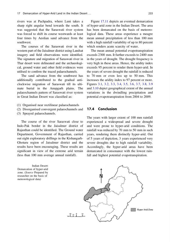
Figure 17.11 depicts an eventual demarcation
of hyper-arid zone in the Indian Desert. The area
has been demarcated on the basis of meteorological data. These areas experience a meagre
mean annual precipitation of less than 100 mm
with a high rainfall variability of up to 80 percent
which renders acute scarcity of water.
The mean annual potential evapotranspiration
exceeds 2300 mm. It further exceeds to 2400 mm
in the years of drought. The drought frequency is
very high in these areas. Hence, the aridity index
exceeds 95 percent to render them hyper-arid. In
the years of severe drought the rainfall is reduced
to 70 mm or even less up to 50 mm. This
increases the aridity index to 97 percent or more.
Figures 3.1, 3.2, 3.3, 3.4, 3.5, 3.6, 3.7, 3.8, 3.9
and 3.10 depict geographical extent of the annual
variations in the dwindling precipitation and
potential evapotranspiration from 2004 to 2009.
17.4 Conclusion
The years with larger extent of 100 mm rainfall
experienced a widespread and severe drought
and were prone to hyper-arid conditions. The
rainfall was reduced by 70 mm to 50 mm in such
years, rendering them distinctly hyper-arid. Out
of 5 years of depiction, 3 years experienced very
severe droughts due to high rainfall variability.
Accordingly, the hyper-arid areas have been
demarcated in consonance with the lowest rainfall and highest potential evapotranspiration.
Fig. 17.11 Indian Desert:
Demarcation of hyper-arid
zone. (Source Prepared by
researcher on the basis of
meteorological data)
17 Demarcation of Hyper-Arid Land in the Indian Desert …
233
sharp right angular bend towards the south. It
was suggested that the Saraswati river system
was forced to shift its course westwards at least
four times by Aeolian sand advance from the
southwest.
The courses of the Saraswati river in the
western part of the Jaisalmer district using Landsat
imagery and field observations were identified.
The signature and migration of Saraswati river in
Thar desert were delineated and the archaeological, ground water and other field evidences were
utilised to confirm the traced palaeochannels.
The sand advance from the southwest has
additionally contributed to the gradual anticlockwise migration of Saraswati till its ultimate burial in the Anupgarh plains. The
palaeochannels pattern of Saraswati river system
in Great Indian Desert was classified as:
(1) Organised near rectilinear palaeochannels
(2) Disorganised convergent palaeochannels and
(3) Sprayed palaeochannels.
The course of the river Saraswati close to
Indo-Pak border in the Jaisalmer district of
Rajasthan could be identified. The Ground water
Department, Government of Rajasthan, carried
out eight exploratory drillings in the KishangarhGhotaru region of Jaisalmer district and the
results have been encouraging. These results are
significant in view of the extreme arid terrain
(less than 100 mm average annual rainfall).
Figure 17.11 depicts an eventual demarcation
of hyper-arid zone in the Indian Desert. The area
has been demarcated on the basis of meteorological data. These areas experience a meagre
mean annual precipitation of less than 100 mm
with a high rainfall variability of up to 80 percent
which renders acute scarcity of water.
The mean annual potential evapotranspiration
exceeds 2300 mm. It further exceeds to 2400 mm
in the years of drought. The drought frequency is
very high in these areas. Hence, the aridity index
exceeds 95 percent to render them hyper-arid. In
the years of severe drought the rainfall is reduced
to 70 mm or even less up to 50 mm. This
increases the aridity index to 97 percent or more.
Figures 3.1, 3.2, 3.3, 3.4, 3.5, 3.6, 3.7, 3.8, 3.9
and 3.10 depict geographical extent of the annual
variations in the dwindling precipitation and
potential evapotranspiration from 2004 to 2009.
17.4 Conclusion
The years with larger extent of 100 mm rainfall
experienced a widespread and severe drought
and were prone to hyper-arid conditions. The
rainfall was reduced by 70 mm to 50 mm in such
years, rendering them distinctly hyper-arid. Out
of 5 years of depiction, 3 years experienced very
severe droughts due to high rainfall variability.
Accordingly, the hyper-arid areas have been
demarcated in consonance with the lowest rainfall and highest potential evapotranspiration.
Fig. 17.11 Indian Desert:
Demarcation of hyper-arid
zone. (Source Prepared by
researcher on the basis of
meteorological data)
17 Demarcation of Hyper-Arid Land in the Indian Desert …
233