

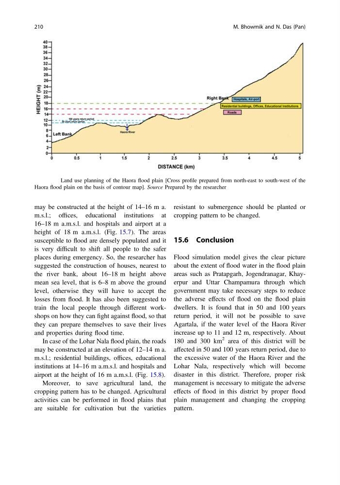
may be constructed at the height of 14–16 m a.
m.s.l.; offices, educational institutions at
16–18 m a.m.s.l. and hospitals and airport at a
height of 18 m a.m.s.l. (Fig. 15.7). The areas
susceptible to flood are densely populated and it
is very difficult to shift all people to the safer
places during emergency. So, the researcher has
suggested the construction of houses, nearest to
the river bank, about 16–18 m height above
mean sea level, that is 6–8 m above the ground
level, otherwise they will have to accept the
losses from flood. It has also been suggested to
train the local people through different workshops on how they can fight against flood, so that
they can prepare themselves to save their lives
and properties during flood time.
In case of the Lohar Nala flood plain, the roads
may be constructed at an elevation of 12–14 m a.
m.s.l.; residential buildings, offices, educational
institutions at 14–16 m a.m.s.l. and hospitals and
airport at the height of 16 m a.m.s.l. (Fig. 15.8).
Moreover, to save agricultural land, the
cropping pattern has to be changed. Agricultural
activities can be performed in flood plains that
are suitable for cultivation but the varieties
resistant to submergence should be planted or
cropping pattern to be changed.
15.6 Conclusion
Flood simulation model gives the clear picture
about the extent of flood water in the flood plain
areas such as Pratapgarh, Jogendranagar, Khayerpur and Uttar Champamura through which
government may take necessary steps to reduce
the adverse effects of flood on the flood plain
dwellers. It is found that in 50 and 100 years
return period, it will not be possible to save
Agartala, if the water level of the Haora River
increase up to 11 and 12 m, respectively. About
180 and 300 km
2 area of this district will be
affected in 50 and 100 years return period, due to
the excessive water of the Haora River and the
Lohar Nala, respectively which will become
disaster in this district. Therefore, proper risk
management is necessary to mitigate the adverse
effects of flood in this district by proper flood
plain management and changing the cropping
pattern.
Fig. 15.7 Land use planning of the Haora flood plain [Cross profile prepared from north-east to south-west of the
Haora flood plain on the basis of contour map]. Source Prepared by the researcher
210
M. Bhowmik and N. Das (Pan)
m.s.l.; offices, educational institutions at
16–18 m a.m.s.l. and hospitals and airport at a
height of 18 m a.m.s.l. (Fig. 15.7). The areas
susceptible to flood are densely populated and it
is very difficult to shift all people to the safer
places during emergency. So, the researcher has
suggested the construction of houses, nearest to
the river bank, about 16–18 m height above
mean sea level, that is 6–8 m above the ground
level, otherwise they will have to accept the
losses from flood. It has also been suggested to
train the local people through different workshops on how they can fight against flood, so that
they can prepare themselves to save their lives
and properties during flood time.
In case of the Lohar Nala flood plain, the roads
may be constructed at an elevation of 12–14 m a.
m.s.l.; residential buildings, offices, educational
institutions at 14–16 m a.m.s.l. and hospitals and
airport at the height of 16 m a.m.s.l. (Fig. 15.8).
Moreover, to save agricultural land, the
cropping pattern has to be changed. Agricultural
activities can be performed in flood plains that
are suitable for cultivation but the varieties
resistant to submergence should be planted or
cropping pattern to be changed.
15.6 Conclusion
Flood simulation model gives the clear picture
about the extent of flood water in the flood plain
areas such as Pratapgarh, Jogendranagar, Khayerpur and Uttar Champamura through which
government may take necessary steps to reduce
the adverse effects of flood on the flood plain
dwellers. It is found that in 50 and 100 years
return period, it will not be possible to save
Agartala, if the water level of the Haora River
increase up to 11 and 12 m, respectively. About
180 and 300 km
2 area of this district will be
affected in 50 and 100 years return period, due to
the excessive water of the Haora River and the
Lohar Nala, respectively which will become
disaster in this district. Therefore, proper risk
management is necessary to mitigate the adverse
effects of flood in this district by proper flood
plain management and changing the cropping
pattern.
Fig. 15.7 Land use planning of the Haora flood plain [Cross profile prepared from north-east to south-west of the
Haora flood plain on the basis of contour map]. Source Prepared by the researcher
210
M. Bhowmik and N. Das (Pan)