

will be scarcity of drinking water during and after
flood. Thus, food crisis and polluted water will
cause many diseases like cholera, typhoid,
dysentery and so on. Therefore, proper risk
management is necessary to mitigate the adverse
effects of flood in this district by proper flood
plain management.
15.5.3 Flood Plain Management
Firstly, it is necessary to save the houses, which
are the property of any people and the standing
crops, which are the sources of income of most
of people of this district. To protect the roads
from flood in the Haora flood plain, all the roads
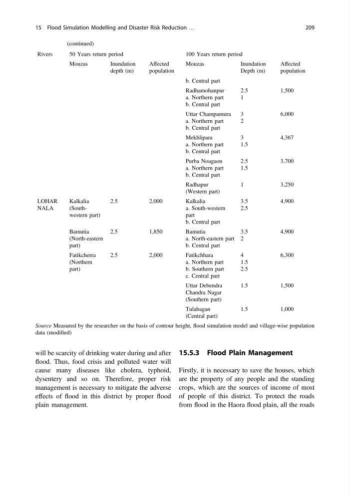
Table 15.3 (continued)
Rivers
50 Years return period
100 Years return period
Mouzas
Inundation
depth (m)
Affected
population
Mouzas
Inundation
Depth (m)
Affected
population
b. Central part
Radhamohanpur
a. Northern part
b. Central part
2.5
1
1,500
Uttar Champamura
a. Northern part
b. Central part
3
2
6,000
Mekhlipara
a. Northern part
b. Central part
3
1.5
4,367
Purba Noagaon
a. Northern part
b. Central part
2.5
1.5
3,700
Radhapur
(Western part)
1
3,250
LOHAR
NALA
Kalkalia
(Southwestern part)
2.5
2,000
Kalkalia
a. South-western
part
b. Central part
3.5
2.5
4,900
Bamutia
(North-eastern
part)
2.5
1,850
Bamutia
a. North-eastern part
b. Central part
3.5
2
4,900
Fatikcherra
(Northern
part)
2.5
2,000
Fatikchhara
a. Northern part
b. Southern part
c. Central part
4
1.5
2.5
6,300
Uttar Debendra
Chandra Nagar
(Southern part)
1.5
1,500
Tulabagan
(Central part)
1.5
1,000
Source Measured by the researcher on the basis of contour height, flood simulation model and village-wise population
data (modified)
15 Flood Simulation Modelling and Disaster Risk Reduction …
209
flood. Thus, food crisis and polluted water will
cause many diseases like cholera, typhoid,
dysentery and so on. Therefore, proper risk
management is necessary to mitigate the adverse
effects of flood in this district by proper flood
plain management.
15.5.3 Flood Plain Management
Firstly, it is necessary to save the houses, which
are the property of any people and the standing
crops, which are the sources of income of most
of people of this district. To protect the roads
from flood in the Haora flood plain, all the roads
Table 15.3 (continued)
Rivers
50 Years return period
100 Years return period
Mouzas
Inundation
depth (m)
Affected
population
Mouzas
Inundation
Depth (m)
Affected
population
b. Central part
Radhamohanpur
a. Northern part
b. Central part
2.5
1
1,500
Uttar Champamura
a. Northern part
b. Central part
3
2
6,000
Mekhlipara
a. Northern part
b. Central part
3
1.5
4,367
Purba Noagaon
a. Northern part
b. Central part
2.5
1.5
3,700
Radhapur
(Western part)
1
3,250
LOHAR
NALA
Kalkalia
(Southwestern part)
2.5
2,000
Kalkalia
a. South-western
part
b. Central part
3.5
2.5
4,900
Bamutia
(North-eastern
part)
2.5
1,850
Bamutia
a. North-eastern part
b. Central part
3.5
2
4,900
Fatikcherra
(Northern
part)
2.5
2,000
Fatikchhara
a. Northern part
b. Southern part
c. Central part
4
1.5
2.5
6,300
Uttar Debendra
Chandra Nagar
(Southern part)
1.5
1,500
Tulabagan
(Central part)
1.5
1,000
Source Measured by the researcher on the basis of contour height, flood simulation model and village-wise population
data (modified)
15 Flood Simulation Modelling and Disaster Risk Reduction …
209