

1.89 m in 2013. The yearly mean groundwater
level fluctuation recorded in the region was
found to be 1.46 m. It is formed due to dependence on the natural recharge and utilization of
water in using domestic and irrigation purposes.
The average depth to water level was varying
between 0.65 m and 1.95 m with an average
fluctuation of 1.23 m in 2012 in the inland dune
regions. In the same region the groundwater table
level was depleted (1.12–4.52 m) with an average fluctuation 3.21 in the year of 2013. The
yearly mean groundwater level fluctuation is
2.22 m. Groundwater levels in both inland dune
area and non-placer sand area aquifer blocks
show little variation from summer to summer,
irrespective of the volumes of winter recharge.
14.1.4.2 Groundwater Level
Fluctuation in Active
Mining Region
In the active mining region, the average depth of
meters below ground level was found to be
increased from 2.94 to 5.52 in January 2012–
January 2013 and this gradually decreased till the
starting of next monsoon. The average groundwater level fluctuation recorded in the active
mining region was 2.94 m in 2012 and 5.52 in
2013. The groundwater level was found to be
lowered from 1.78 to 4.79 m below ground level
in 2012 and then increased up to 3.36 to 7.92 m
below ground level in 2013. In this mining
region (Uvari, Kuttam, Karikoil, Navaladi) the
yearly mean groundwater level fluctuation
recorded the highest fall of groundwater table
(4.23 m) in 2012 to 2013 among all the ten
monitoring wells. For that reason the wave runup
on the swash zone and backshore will induce
seawater infiltration into the coastal aquifer during the water table lowered. The infiltration is
favored based on the permeability and grain size.
This variation formed due to continuous scrapping of dunes along the coastal stretch, thus
declines the storage capacity of groundwater into
the freshwater aquifers apart from normal
groundwater recharge. In the mining sites, more
water is required to use for mineral washing and
other purposes. Therefore, these areas have
pumped more groundwater than limits, and water
table was highly depleted. Over pumping of
groundwater wells located near the shoreline is a
major cause of encroachment of saline water into
the aquifers and may lead to seawater intrusion.
Because of its high density, saltwater goes inland
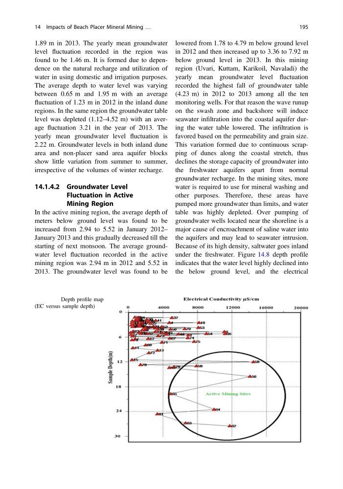
under the freshwater. Figure 14.8 depth profile
indicates that the water level highly declined into
the below ground level, and the electrical
Fig. 14.8 Depth profile map
(EC versus sample depth)
14 Impacts of Beach Placer Mineral Mining …
195
level fluctuation recorded in the region was
found to be 1.46 m. It is formed due to dependence on the natural recharge and utilization of
water in using domestic and irrigation purposes.
The average depth to water level was varying
between 0.65 m and 1.95 m with an average
fluctuation of 1.23 m in 2012 in the inland dune
regions. In the same region the groundwater table
level was depleted (1.12–4.52 m) with an average fluctuation 3.21 in the year of 2013. The
yearly mean groundwater level fluctuation is
2.22 m. Groundwater levels in both inland dune
area and non-placer sand area aquifer blocks
show little variation from summer to summer,
irrespective of the volumes of winter recharge.
14.1.4.2 Groundwater Level
Fluctuation in Active
Mining Region
In the active mining region, the average depth of
meters below ground level was found to be
increased from 2.94 to 5.52 in January 2012–
January 2013 and this gradually decreased till the
starting of next monsoon. The average groundwater level fluctuation recorded in the active
mining region was 2.94 m in 2012 and 5.52 in
2013. The groundwater level was found to be
lowered from 1.78 to 4.79 m below ground level
in 2012 and then increased up to 3.36 to 7.92 m
below ground level in 2013. In this mining
region (Uvari, Kuttam, Karikoil, Navaladi) the
yearly mean groundwater level fluctuation
recorded the highest fall of groundwater table
(4.23 m) in 2012 to 2013 among all the ten
monitoring wells. For that reason the wave runup
on the swash zone and backshore will induce
seawater infiltration into the coastal aquifer during the water table lowered. The infiltration is
favored based on the permeability and grain size.
This variation formed due to continuous scrapping of dunes along the coastal stretch, thus
declines the storage capacity of groundwater into
the freshwater aquifers apart from normal
groundwater recharge. In the mining sites, more
water is required to use for mineral washing and
other purposes. Therefore, these areas have
pumped more groundwater than limits, and water
table was highly depleted. Over pumping of
groundwater wells located near the shoreline is a
major cause of encroachment of saline water into
the aquifers and may lead to seawater intrusion.
Because of its high density, saltwater goes inland
under the freshwater. Figure 14.8 depth profile
indicates that the water level highly declined into
the below ground level, and the electrical
Fig. 14.8 Depth profile map
(EC versus sample depth)
14 Impacts of Beach Placer Mineral Mining …
195