

May to August in all the regions. That is, the
water level was found to be very near to the
ground level during monsoon period and gradually lowered during dry period. Table 14.3 shows
the average depth to water table below the
ground level recorded in meters from January
2012 to November 2013. In all the regions, water
level was found to be increased gradually in the
month of January due to the effect of heavy
rainfall received during the monsoon seasons.
14.1.4.1 Groundwater Level
Fluctuation in NonPlacer and Inland Dune
Region
In the non-placer sand region, the average depth
to water level was minimum 0.86 m to maximum
1.45 m below ground level, resulting in the
average groundwater level fluctuation as 1.02 m
in the year 2012. In the same region the average
groundwater level fluctuation was recorded as
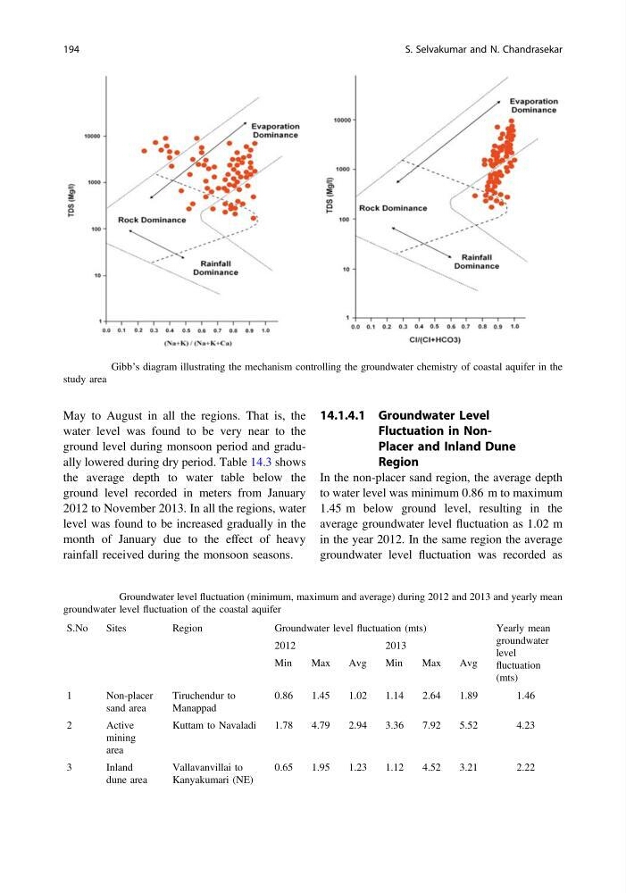
Fig. 14.7 Gibb’s diagram illustrating the mechanism controlling the groundwater chemistry of coastal aquifer in the
study area
Table 14.3 Groundwater level fluctuation (minimum, maximum and average) during 2012 and 2013 and yearly mean
groundwater level fluctuation of the coastal aquifer
S.No
Sites
Region
Groundwater level fluctuation (mts)
Yearly mean
groundwater
level
fluctuation
(mts)
2012
2013
Min
Max
Avg
Min
Max
Avg
1
Non-placer
sand area
Tiruchendur to
Manappad
0.86
1.45
1.02
1.14
2.64
1.89
1.46
2
Active
mining
area
Kuttam to Navaladi
1.78
4.79
2.94
3.36
7.92
5.52
4.23
3
Inland
dune area
Vallavanvillai to
Kanyakumari (NE)
0.65
1.95
1.23
1.12
4.52
3.21
2.22
194
S. Selvakumar and N. Chandrasekar
water level was found to be very near to the
ground level during monsoon period and gradually lowered during dry period. Table 14.3 shows
the average depth to water table below the
ground level recorded in meters from January
2012 to November 2013. In all the regions, water
level was found to be increased gradually in the
month of January due to the effect of heavy
rainfall received during the monsoon seasons.
14.1.4.1 Groundwater Level
Fluctuation in NonPlacer and Inland Dune
Region
In the non-placer sand region, the average depth
to water level was minimum 0.86 m to maximum
1.45 m below ground level, resulting in the
average groundwater level fluctuation as 1.02 m
in the year 2012. In the same region the average
groundwater level fluctuation was recorded as
Fig. 14.7 Gibb’s diagram illustrating the mechanism controlling the groundwater chemistry of coastal aquifer in the
study area
Table 14.3 Groundwater level fluctuation (minimum, maximum and average) during 2012 and 2013 and yearly mean
groundwater level fluctuation of the coastal aquifer
S.No
Sites
Region
Groundwater level fluctuation (mts)
Yearly mean
groundwater
level
fluctuation
(mts)
2012
2013
Min
Max
Avg
Min
Max
Avg
1
Non-placer
sand area
Tiruchendur to
Manappad
0.86
1.45
1.02
1.14
2.64
1.89
1.46
2
Active
mining
area
Kuttam to Navaladi
1.78
4.79
2.94
3.36
7.92
5.52
4.23
3
Inland
dune area
Vallavanvillai to
Kanyakumari (NE)
0.65
1.95
1.23
1.12
4.52
3.21
2.22
194
S. Selvakumar and N. Chandrasekar