

after successful planting of trees the DLVS
workers and locals of Gadkharak village, Garhwal Himalaya made small Jal Talais (water
ponds), in the upper parts of the village forest, to
stall the immense surface runoff, which otherwise
rapidly meander down hills (Bandooni et al.
2017). The vast, top ground tree cover facilitated
the natural process infiltration and increases the
water holding capacity of the land. Uttis (elder) is
known to give out roots that almost spread like a
network, reaching far into the soil, serving
almost like capillaries supplying nourishment
and water into the deep recesses of the earth. In
the present research an attempt has been made to
evaluate, examine, and understand the problems
of water and forest resources and participation of
community, social worker, and NGOs to manage
them in Garhwal Himalaya, Uttarakhand.
12.2 Study Area
Uttarakhand state is characterized by high altitudinal mountains and deep valley. There are 13
districts in this mountain-dominated state which
accounts for more than 80% characterized by
hilly regions. The coordinate of Uttarakhand is at
28°43’N to 31°27’N, 77°34’E to 81°02’E. The
total geographical area of Uttarakhand is 53,483
sq. km (Bandooni 2004), out of which 46,035 sq.
km is hilly area and remaining are plain area. In
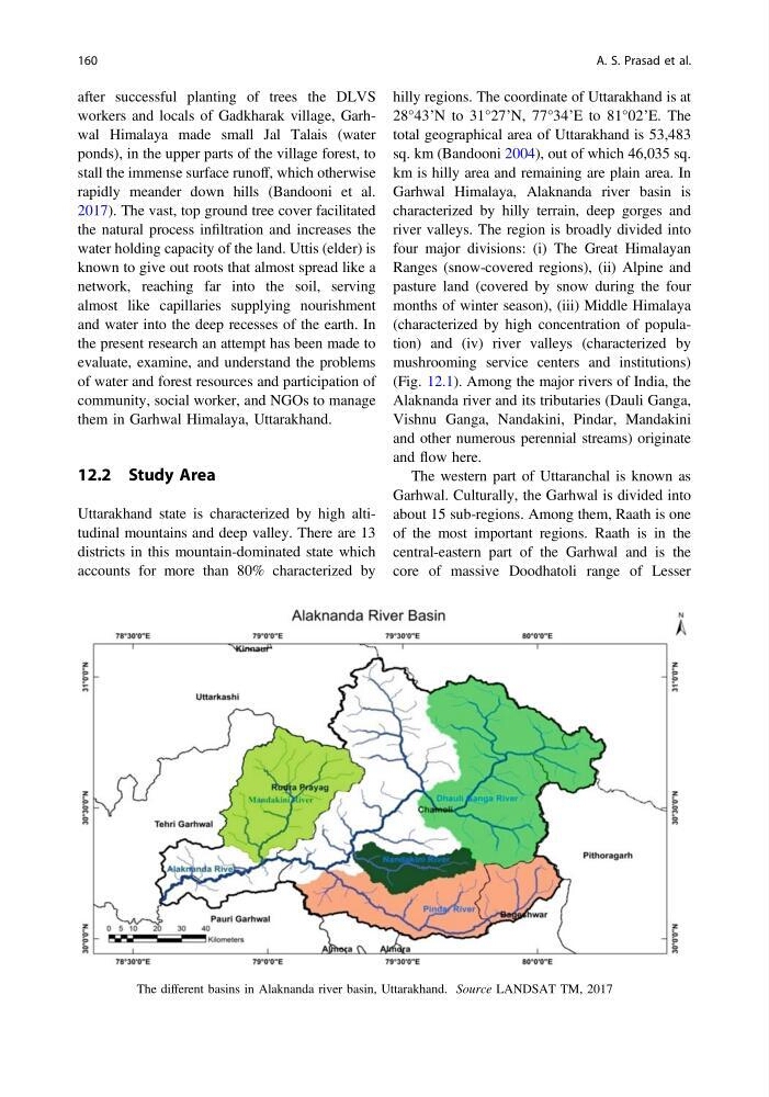
Garhwal Himalaya, Alaknanda river basin is
characterized by hilly terrain, deep gorges and
river valleys. The region is broadly divided into
four major divisions: (i) The Great Himalayan
Ranges (snow-covered regions), (ii) Alpine and
pasture land (covered by snow during the four
months of winter season), (iii) Middle Himalaya
(characterized by high concentration of population) and (iv) river valleys (characterized by
mushrooming service centers and institutions)
(Fig. 12.1). Among the major rivers of India, the
Alaknanda river and its tributaries (Dauli Ganga,
Vishnu Ganga, Nandakini, Pindar, Mandakini
and other numerous perennial streams) originate
and flow here.
The western part of Uttaranchal is known as
Garhwal. Culturally, the Garhwal is divided into
about 15 sub-regions. Among them, Raath is one
of the most important regions. Raath is in the
central-eastern part of the Garhwal and is the
core of massive Doodhatoli range of Lesser
Fig. 12.1 The different basins in Alaknanda river basin, Uttarakhand. Source LANDSAT TM, 2017
160
A. S. Prasad et al.
workers and locals of Gadkharak village, Garhwal Himalaya made small Jal Talais (water
ponds), in the upper parts of the village forest, to
stall the immense surface runoff, which otherwise
rapidly meander down hills (Bandooni et al.
2017). The vast, top ground tree cover facilitated
the natural process infiltration and increases the
water holding capacity of the land. Uttis (elder) is
known to give out roots that almost spread like a
network, reaching far into the soil, serving
almost like capillaries supplying nourishment
and water into the deep recesses of the earth. In
the present research an attempt has been made to
evaluate, examine, and understand the problems
of water and forest resources and participation of
community, social worker, and NGOs to manage
them in Garhwal Himalaya, Uttarakhand.
12.2 Study Area
Uttarakhand state is characterized by high altitudinal mountains and deep valley. There are 13
districts in this mountain-dominated state which
accounts for more than 80% characterized by
hilly regions. The coordinate of Uttarakhand is at
28°43’N to 31°27’N, 77°34’E to 81°02’E. The
total geographical area of Uttarakhand is 53,483
sq. km (Bandooni 2004), out of which 46,035 sq.
km is hilly area and remaining are plain area. In
Garhwal Himalaya, Alaknanda river basin is
characterized by hilly terrain, deep gorges and
river valleys. The region is broadly divided into
four major divisions: (i) The Great Himalayan
Ranges (snow-covered regions), (ii) Alpine and
pasture land (covered by snow during the four
months of winter season), (iii) Middle Himalaya
(characterized by high concentration of population) and (iv) river valleys (characterized by
mushrooming service centers and institutions)
(Fig. 12.1). Among the major rivers of India, the
Alaknanda river and its tributaries (Dauli Ganga,
Vishnu Ganga, Nandakini, Pindar, Mandakini
and other numerous perennial streams) originate
and flow here.
The western part of Uttaranchal is known as
Garhwal. Culturally, the Garhwal is divided into
about 15 sub-regions. Among them, Raath is one
of the most important regions. Raath is in the
central-eastern part of the Garhwal and is the
core of massive Doodhatoli range of Lesser
Fig. 12.1 The different basins in Alaknanda river basin, Uttarakhand. Source LANDSAT TM, 2017
160
A. S. Prasad et al.