

310
J. Fac-Beneda et al.
0
200
400
600
800
1000
1200
Świnoujście
Kołobrzeg
Ustka
Łeba
Hel
Szczecin
Resko
Koszalin
Lębork
Gorzów Wlk.
Chojnice
średnia
PrecipitaƟon mm
StaƟon
average
min
max
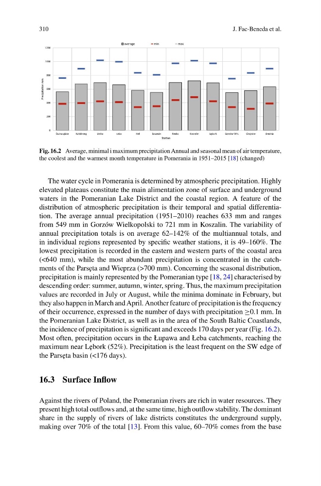
Fig. 16.2 Average, minimal i maximum precipitation Annual and seasonal mean of air temperature,
the coolest and the warmest month temperature in Pomerania in 1951–2015 [18] (changed)
The water cycle in Pomerania is determined by atmospheric precipitation. Highly
elevated plateaus constitute the main alimentation zone of surface and underground
waters in the Pomeranian Lake District and the coastal region. A feature of the
distribution of atmospheric precipitation is their temporal and spatial differentiation. The average annual precipitation (1951–2010) reaches 633 mm and ranges
from 549 mm in Gorzów Wielkopolski to 721 mm in Koszalin. The variability of
annual precipitation totals is on average 62–142% of the multiannual totals, and
in individual regions represented by specific weather stations, it is 49–160%. The
lowest precipitation is recorded in the eastern and western parts of the coastal area
(<640 mm), while the most abundant precipitation is concentrated in the catchments of the Pars˛ eta and Wieprza (>700 mm). Concerning the seasonal distribution,
precipitation is mainly represented by the Pomeranian type [18, 24] characterised by
descending order: summer, autumn, winter, spring. Thus, the maximum precipitation
values are recorded in July or August, while the minima dominate in February, but
they also happen in March and April. Another feature of precipitation is the frequency
of their occurrence, expressed in the number of days with precipitation ≥0.1 mm. In
the Pomeranian Lake District, as well as in the area of the South Baltic Coastlands,
the incidence of precipitation is significant and exceeds 170 days per year (Fig. 16.2).
Most often, precipitation occurs in the Łupawa and Łeba catchments, reaching the
maximum near L˛ ebork (52%). Precipitation is the least frequent on the SW edge of
the Pars˛ eta basin (<176 days).
16.3 Surface Inflow
Against the rivers of Poland, the Pomeranian rivers are rich in water resources. They
present high total outflows and, at the same time, high outflow stability. The dominant
share in the supply of rivers of lake districts constitutes the underground supply,
making over 70% of the total [13]. From this value, 60–70% comes from the base
J. Fac-Beneda et al.
0
200
400
600
800
1000
1200
Świnoujście
Kołobrzeg
Ustka
Łeba
Hel
Szczecin
Resko
Koszalin
Lębork
Gorzów Wlk.
Chojnice
średnia
PrecipitaƟon mm
StaƟon
average
min
max
Fig. 16.2 Average, minimal i maximum precipitation Annual and seasonal mean of air temperature,
the coolest and the warmest month temperature in Pomerania in 1951–2015 [18] (changed)
The water cycle in Pomerania is determined by atmospheric precipitation. Highly
elevated plateaus constitute the main alimentation zone of surface and underground
waters in the Pomeranian Lake District and the coastal region. A feature of the
distribution of atmospheric precipitation is their temporal and spatial differentiation. The average annual precipitation (1951–2010) reaches 633 mm and ranges
from 549 mm in Gorzów Wielkopolski to 721 mm in Koszalin. The variability of
annual precipitation totals is on average 62–142% of the multiannual totals, and
in individual regions represented by specific weather stations, it is 49–160%. The
lowest precipitation is recorded in the eastern and western parts of the coastal area
(<640 mm), while the most abundant precipitation is concentrated in the catchments of the Pars˛ eta and Wieprza (>700 mm). Concerning the seasonal distribution,
precipitation is mainly represented by the Pomeranian type [18, 24] characterised by
descending order: summer, autumn, winter, spring. Thus, the maximum precipitation
values are recorded in July or August, while the minima dominate in February, but
they also happen in March and April. Another feature of precipitation is the frequency
of their occurrence, expressed in the number of days with precipitation ≥0.1 mm. In
the Pomeranian Lake District, as well as in the area of the South Baltic Coastlands,
the incidence of precipitation is significant and exceeds 170 days per year (Fig. 16.2).
Most often, precipitation occurs in the Łupawa and Łeba catchments, reaching the
maximum near L˛ ebork (52%). Precipitation is the least frequent on the SW edge of
the Pars˛ eta basin (<176 days).
16.3 Surface Inflow
Against the rivers of Poland, the Pomeranian rivers are rich in water resources. They
present high total outflows and, at the same time, high outflow stability. The dominant
share in the supply of rivers of lake districts constitutes the underground supply,
making over 70% of the total [13]. From this value, 60–70% comes from the base