

Warm
Warm
Cold
Bora
Foehn
Cold
a)
b)
H
H
z i
z i
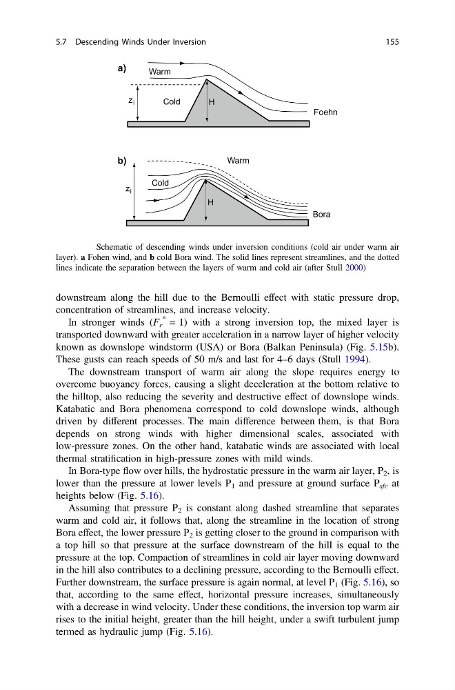
Fig. 5.15 Schematic of descending winds under inversion conditions (cold air under warm air
layer). a Fohen wind, and b cold Bora wind. The solid lines represent streamlines, and the dotted
lines indicate the separation between the layers of warm and cold air (after Stull 2000)
downstream along the hill due to the Bernoulli effect with static pressure drop,
concentration of streamlines, and increase velocity.
In stronger winds (F r
* = 1) with a strong inversion top, the mixed layer is
transported downward with greater acceleration in a narrow layer of higher velocity
known as downslope windstorm (USA) or Bora (Balkan Peninsula) (Fig. 5.15b).
These gusts can reach speeds of 50 m/s and last for 4–6 days (Stull 1994).
The downstream transport of warm air along the slope requires energy to
overcome buoyancy forces, causing a slight deceleration at the bottom relative to
the hilltop, also reducing the severity and destructive effect of downslope winds.
Katabatic and Bora phenomena correspond to cold downslope winds, although
driven by different processes. The main difference between them, is that Bora
depends on strong winds with higher dimensional scales, associated with
low-pressure zones. On the other hand, katabatic winds are associated with local
thermal stratification in high-pressure zones with mild winds.
In Bora-type flow over hills, the hydrostatic pressure in the warm air layer, P 2 , is
lower than the pressure at lower levels P 1 and pressure at ground surface P sfc at
heights below (Fig. 5.16).
Assuming that pressure P 2 is constant along dashed streamline that separates
warm and cold air, it follows that, along the streamline in the location of strong
Bora effect, the lower pressure P 2 is getting closer to the ground in comparison with
a top hill so that pressure at the surface downstream of the hill is equal to the
pressure at the top. Compaction of streamlines in cold air layer moving downward
in the hill also contributes to a declining pressure, according to the Bernoulli effect.
Further downstream, the surface pressure is again normal, at level P 1 (Fig. 5.16), so
that, according to the same effect, horizontal pressure increases, simultaneously
with a decrease in wind velocity. Under these conditions, the inversion top warm air
rises to the initial height, greater than the hill height, under a swift turbulent jump
termed as hydraulic jump (Fig. 5.16).
5.7 Descending Winds Under Inversion
155
Warm
Cold
Bora
Foehn
Cold
a)
b)
H
H
z i
z i
Fig. 5.15 Schematic of descending winds under inversion conditions (cold air under warm air
layer). a Fohen wind, and b cold Bora wind. The solid lines represent streamlines, and the dotted
lines indicate the separation between the layers of warm and cold air (after Stull 2000)
downstream along the hill due to the Bernoulli effect with static pressure drop,
concentration of streamlines, and increase velocity.
In stronger winds (F r
* = 1) with a strong inversion top, the mixed layer is
transported downward with greater acceleration in a narrow layer of higher velocity
known as downslope windstorm (USA) or Bora (Balkan Peninsula) (Fig. 5.15b).
These gusts can reach speeds of 50 m/s and last for 4–6 days (Stull 1994).
The downstream transport of warm air along the slope requires energy to
overcome buoyancy forces, causing a slight deceleration at the bottom relative to
the hilltop, also reducing the severity and destructive effect of downslope winds.
Katabatic and Bora phenomena correspond to cold downslope winds, although
driven by different processes. The main difference between them, is that Bora
depends on strong winds with higher dimensional scales, associated with
low-pressure zones. On the other hand, katabatic winds are associated with local
thermal stratification in high-pressure zones with mild winds.
In Bora-type flow over hills, the hydrostatic pressure in the warm air layer, P 2 , is
lower than the pressure at lower levels P 1 and pressure at ground surface P sfc at
heights below (Fig. 5.16).
Assuming that pressure P 2 is constant along dashed streamline that separates
warm and cold air, it follows that, along the streamline in the location of strong
Bora effect, the lower pressure P 2 is getting closer to the ground in comparison with
a top hill so that pressure at the surface downstream of the hill is equal to the
pressure at the top. Compaction of streamlines in cold air layer moving downward
in the hill also contributes to a declining pressure, according to the Bernoulli effect.
Further downstream, the surface pressure is again normal, at level P 1 (Fig. 5.16), so
that, according to the same effect, horizontal pressure increases, simultaneously
with a decrease in wind velocity. Under these conditions, the inversion top warm air
rises to the initial height, greater than the hill height, under a swift turbulent jump
termed as hydraulic jump (Fig. 5.16).
5.7 Descending Winds Under Inversion
155