

17.3 Environmental Flow Assessment and Water Resources…
373
Maintain fisheries
Maintain habitat for
benthic invertebrates &
amphibians
Estuarine habitats
(salinity gradient,
mudflats)
Flow Regime
Maintain biofilms and
provide inputs of
terrestrial carbon from
stream margins
Spawning areas in
Zhuxi and Yongían
Bankfull &
overbank flows
Minimum (low) flows
flow pulses
Maintain longitudinal
connectivity for fish
movement
Deep pools (e.g. eels,
carp sp)
Maintain channel
morphology (pools,
riffles, vegetation free
bars)
Transport eggs and
larvae downstream
HABITAT
Shallow backwaters
(e.g. whitefish, catfish)
REPRODUCTION
FOOD RESOURCES
Macrophytes, algae &
detritus (e.g. ling-lake)
Scour vegetation from
in-channel bars
Maintain riparian vegetation
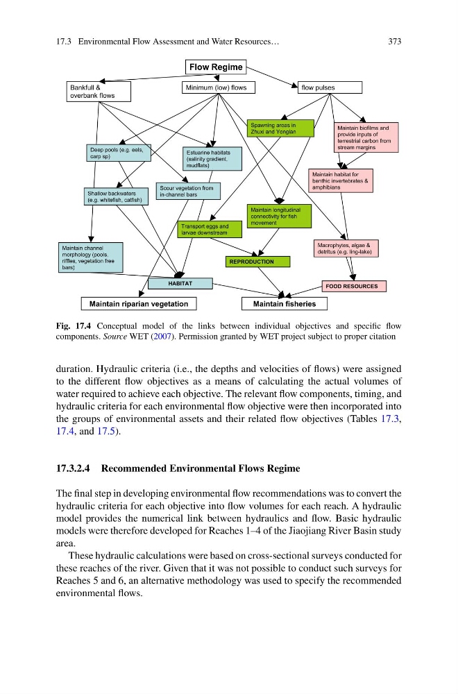
Fig. 17.4 Conceptual model of the links between individual objectives and specific flow
components. Source WET (2007). Permission granted by WET project subject to proper citation
duration. Hydraulic criteria (i.e., the depths and velocities of flows) were assigned
to the different flow objectives as a means of calculating the actual volumes of
water required to achieve each objective. The relevant flow components, timing, and
hydraulic criteria for each environmental flow objective were then incorporated into
the groups of environmental assets and their related flow objectives (Tables 17.3,
17.4, and 17.5).
17.3.2.4 Recommended Environmental Flows Regime
The final step in developing environmental flow recommendations was to convert the
hydraulic criteria for each objective into flow volumes for each reach. A hydraulic
model provides the numerical link between hydraulics and flow. Basic hydraulic
models were therefore developed for Reaches 1–4 of the Jiaojiang River Basin study
area.
These hydraulic calculations were based on cross-sectional surveys conducted for
these reaches of the river. Given that it was not possible to conduct such surveys for
Reaches 5 and 6, an alternative methodology was used to specify the recommended
environmental flows.
373
Maintain fisheries
Maintain habitat for
benthic invertebrates &
amphibians
Estuarine habitats
(salinity gradient,
mudflats)
Flow Regime
Maintain biofilms and
provide inputs of
terrestrial carbon from
stream margins
Spawning areas in
Zhuxi and Yongían
Bankfull &
overbank flows
Minimum (low) flows
flow pulses
Maintain longitudinal
connectivity for fish
movement
Deep pools (e.g. eels,
carp sp)
Maintain channel
morphology (pools,
riffles, vegetation free
bars)
Transport eggs and
larvae downstream
HABITAT
Shallow backwaters
(e.g. whitefish, catfish)
REPRODUCTION
FOOD RESOURCES
Macrophytes, algae &
detritus (e.g. ling-lake)
Scour vegetation from
in-channel bars
Maintain riparian vegetation
Fig. 17.4 Conceptual model of the links between individual objectives and specific flow
components. Source WET (2007). Permission granted by WET project subject to proper citation
duration. Hydraulic criteria (i.e., the depths and velocities of flows) were assigned
to the different flow objectives as a means of calculating the actual volumes of
water required to achieve each objective. The relevant flow components, timing, and
hydraulic criteria for each environmental flow objective were then incorporated into
the groups of environmental assets and their related flow objectives (Tables 17.3,
17.4, and 17.5).
17.3.2.4 Recommended Environmental Flows Regime
The final step in developing environmental flow recommendations was to convert the
hydraulic criteria for each objective into flow volumes for each reach. A hydraulic
model provides the numerical link between hydraulics and flow. Basic hydraulic
models were therefore developed for Reaches 1–4 of the Jiaojiang River Basin study
area.
These hydraulic calculations were based on cross-sectional surveys conducted for
these reaches of the river. Given that it was not possible to conduct such surveys for
Reaches 5 and 6, an alternative methodology was used to specify the recommended
environmental flows.