

17.3 Environmental Flow Assessment and Water Resources…
371
0
10
20
30
40
50
60
70
80
90
100
0
20
40
60
80
100
120
140
Chainage from Zhuxi Dam (km)
Elevation (m ASL)
Reach 1
Reach 2
Reach 3
Reach 4
Reach 5 (Lingjiang) and 6 (Jiaojiang)
Zhuxi
Lingjiang
Jiaojiang
Linhai
Yong'anxi
Taizhou
Bay
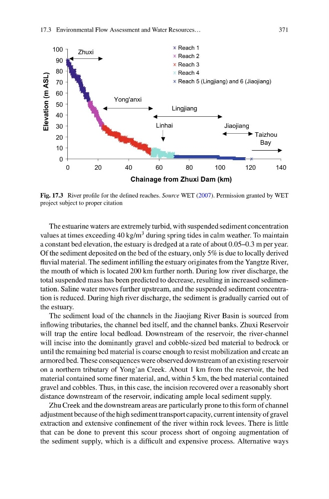
Fig. 17.3 River profile for the defined reaches. Source WET (2007). Permission granted by WET
project subject to proper citation
The estuarine waters are extremely turbid, with suspended sediment concentration
values at times exceeding 40 kg/m
3 during spring tides in calm weather. To maintain
a constant bed elevation, the estuary is dredged at a rate of about 0.05–0.3 m per year.
Of the sediment deposited on the bed of the estuary, only 5% is due to locally derived
fluvial material. The sediment infilling the estuary originates from the Yangtze River,
the mouth of which is located 200 km further north. During low river discharge, the
total suspended mass has been predicted to decrease, resulting in increased sedimentation. Saline water moves further upstream, and the suspended sediment concentration is reduced. During high river discharge, the sediment is gradually carried out of
the estuary.
The sediment load of the channels in the Jiaojiang River Basin is sourced from
inflowing tributaries, the channel bed itself, and the channel banks. Zhuxi Reservoir
will trap the entire local bedload. Downstream of the reservoir, the river-channel
will incise into the dominantly gravel and cobble-sized bed material to bedrock or
until the remaining bed material is coarse enough to resist mobilization and create an
armored bed. These consequences were observed downstream of an existing reservoir
on a northern tributary of Yong’an Creek. About 1 km from the reservoir, the bed
material contained some finer material, and, within 5 km, the bed material contained
gravel and cobbles. Thus, in this case, the incision recovered over a reasonably short
distance downstream of the reservoir, indicating ample local sediment supply.
Zhu Creek and the downstream areas are particularly prone to this form of channel
adjustment because of the high sediment transport capacity, current intensity of gravel
extraction and extensive confinement of the river within rock levees. There is little
that can be done to prevent this scour process short of ongoing augmentation of
the sediment supply, which is a difficult and expensive process. Alternative ways
371
0
10
20
30
40
50
60
70
80
90
100
0
20
40
60
80
100
120
140
Chainage from Zhuxi Dam (km)
Elevation (m ASL)
Reach 1
Reach 2
Reach 3
Reach 4
Reach 5 (Lingjiang) and 6 (Jiaojiang)
Zhuxi
Lingjiang
Jiaojiang
Linhai
Yong'anxi
Taizhou
Bay
Fig. 17.3 River profile for the defined reaches. Source WET (2007). Permission granted by WET
project subject to proper citation
The estuarine waters are extremely turbid, with suspended sediment concentration
values at times exceeding 40 kg/m
3 during spring tides in calm weather. To maintain
a constant bed elevation, the estuary is dredged at a rate of about 0.05–0.3 m per year.
Of the sediment deposited on the bed of the estuary, only 5% is due to locally derived
fluvial material. The sediment infilling the estuary originates from the Yangtze River,
the mouth of which is located 200 km further north. During low river discharge, the
total suspended mass has been predicted to decrease, resulting in increased sedimentation. Saline water moves further upstream, and the suspended sediment concentration is reduced. During high river discharge, the sediment is gradually carried out of
the estuary.
The sediment load of the channels in the Jiaojiang River Basin is sourced from
inflowing tributaries, the channel bed itself, and the channel banks. Zhuxi Reservoir
will trap the entire local bedload. Downstream of the reservoir, the river-channel
will incise into the dominantly gravel and cobble-sized bed material to bedrock or
until the remaining bed material is coarse enough to resist mobilization and create an
armored bed. These consequences were observed downstream of an existing reservoir
on a northern tributary of Yong’an Creek. About 1 km from the reservoir, the bed
material contained some finer material, and, within 5 km, the bed material contained
gravel and cobbles. Thus, in this case, the incision recovered over a reasonably short
distance downstream of the reservoir, indicating ample local sediment supply.
Zhu Creek and the downstream areas are particularly prone to this form of channel
adjustment because of the high sediment transport capacity, current intensity of gravel
extraction and extensive confinement of the river within rock levees. There is little
that can be done to prevent this scour process short of ongoing augmentation of
the sediment supply, which is a difficult and expensive process. Alternative ways