

370
17 Environmental Flow Definition and Management: A Case Study …
0%
10%
20%
30%
40%
50%
60%
70%
80%
90%
100%
10
100
1000
Grain size (mm)
Cumulative percent finer than
Reach 1 (upper)
Reach 1 (middle)
Reach 1 (lower)
Reach 3 (upper)
mediumcoarse
small
Gravel
very coarse
Cobble
large
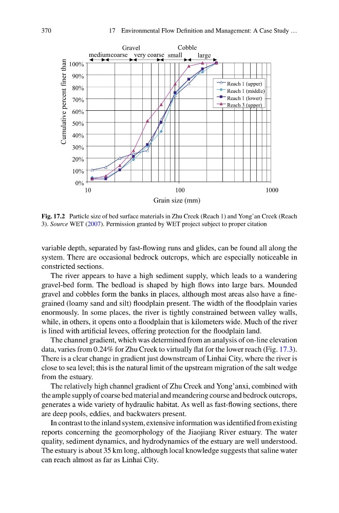
Fig. 17.2 Particle size of bed surface materials in Zhu Creek (Reach 1) and Yong’an Creek (Reach
3). Source WET (2007). Permission granted by WET project subject to proper citation
variable depth, separated by fast-flowing runs and glides, can be found all along the
system. There are occasional bedrock outcrops, which are especially noticeable in
constricted sections.
The river appears to have a high sediment supply, which leads to a wandering
gravel-bed form. The bedload is shaped by high flows into large bars. Mounded
gravel and cobbles form the banks in places, although most areas also have a finegrained (loamy sand and silt) floodplain present. The width of the floodplain varies
enormously. In some places, the river is tightly constrained between valley walls,
while, in others, it opens onto a floodplain that is kilometers wide. Much of the river
is lined with artificial levees, offering protection for the floodplain land.
The channel gradient, which was determined from an analysis of on-line elevation
data, varies from 0.24% for Zhu Creek to virtually flat for the lower reach (Fig. 17.3).
There is a clear change in gradient just downstream of Linhai City, where the river is
close to sea level; this is the natural limit of the upstream migration of the salt wedge
from the estuary.
The relatively high channel gradient of Zhu Creek and Yong’anxi, combined with
the ample supply of coarse bed material and meandering course and bedrock outcrops,
generates a wide variety of hydraulic habitat. As well as fast-flowing sections, there
are deep pools, eddies, and backwaters present.
In contrast to the inland system, extensive information was identified from existing
reports concerning the geomorphology of the Jiaojiang River estuary. The water
quality, sediment dynamics, and hydrodynamics of the estuary are well understood.
The estuary is about 35 km long, although local knowledge suggests that saline water
can reach almost as far as Linhai City.
17 Environmental Flow Definition and Management: A Case Study …
0%
10%
20%
30%
40%
50%
60%
70%
80%
90%
100%
10
100
1000
Grain size (mm)
Cumulative percent finer than
Reach 1 (upper)
Reach 1 (middle)
Reach 1 (lower)
Reach 3 (upper)
mediumcoarse
small
Gravel
very coarse
Cobble
large
Fig. 17.2 Particle size of bed surface materials in Zhu Creek (Reach 1) and Yong’an Creek (Reach
3). Source WET (2007). Permission granted by WET project subject to proper citation
variable depth, separated by fast-flowing runs and glides, can be found all along the
system. There are occasional bedrock outcrops, which are especially noticeable in
constricted sections.
The river appears to have a high sediment supply, which leads to a wandering
gravel-bed form. The bedload is shaped by high flows into large bars. Mounded
gravel and cobbles form the banks in places, although most areas also have a finegrained (loamy sand and silt) floodplain present. The width of the floodplain varies
enormously. In some places, the river is tightly constrained between valley walls,
while, in others, it opens onto a floodplain that is kilometers wide. Much of the river
is lined with artificial levees, offering protection for the floodplain land.
The channel gradient, which was determined from an analysis of on-line elevation
data, varies from 0.24% for Zhu Creek to virtually flat for the lower reach (Fig. 17.3).
There is a clear change in gradient just downstream of Linhai City, where the river is
close to sea level; this is the natural limit of the upstream migration of the salt wedge
from the estuary.
The relatively high channel gradient of Zhu Creek and Yong’anxi, combined with
the ample supply of coarse bed material and meandering course and bedrock outcrops,
generates a wide variety of hydraulic habitat. As well as fast-flowing sections, there
are deep pools, eddies, and backwaters present.
In contrast to the inland system, extensive information was identified from existing
reports concerning the geomorphology of the Jiaojiang River estuary. The water
quality, sediment dynamics, and hydrodynamics of the estuary are well understood.
The estuary is about 35 km long, although local knowledge suggests that saline water
can reach almost as far as Linhai City.