

306
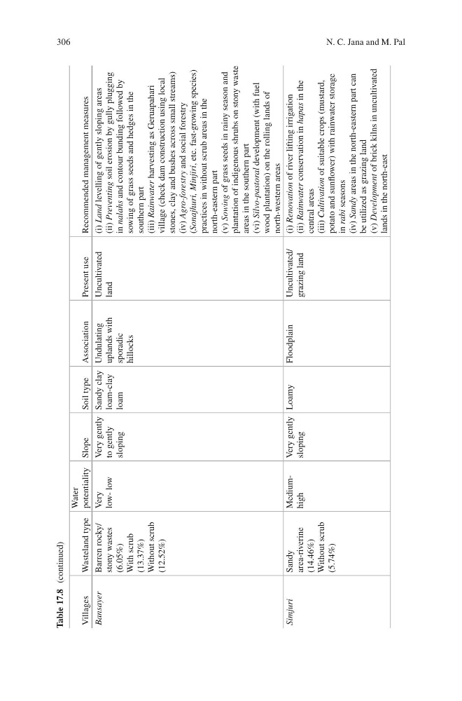
Table 17.8 (continued)
Villages
Wasteland type
Water
potentiality Slope
Soil type
Association
Present use
Recommended management measures
Bansayer
Barren rocky/
stony wastes
(6.05%)
With scrub
(13.37%)
Without scrub
(12.52%)
Very
low- low
Very gently
to gently
sloping
Sandy clay
loam-clay
loam
Undulating
uplands with
sporadic
hillocks
Uncultivated
land
(i) Land
levelling of gently sloping areas
(ii) Preventing
soil erosion by gully plugging
in nalahs
and contour bunding followed by
sowing of grass seeds and hedges in the
southern part
(iii) Rainwater
harvesting as Geruapahari
village (check dam construction using local
stones, clay and bushes across small streams)
(iv) Agro-forestry
and social forestry
(Sonajhuri, Minjiri,
etc. fast-growing species)
practices in without scrub areas in the
north-eastern part
(v) Sowing
of grass seeds in rainy season and
plantation of indigenous shrubs on stony waste
areas in the southern part
(vi) Silvo-pastoral
development (with fuel
wood plantation) on the rolling lands of
north-western areas
Simjuri
Sandy
area- riverine
(14.46%)
Without scrub
(5.74%)
Mediumhigh
Very gently
sloping
Loamy
Floodplain
Uncultivated/
grazing land
(i) Renovation
of river lifting irrigation
(ii) Rainwater
conservation in hapas
in the
central areas
(iii) Cultivation
of suitable crops (mustard,
potato and sunflower) with rainwater storage
in rabi
seasons
(iv) Sandy
areas in the north-eastern part can
be utilized as grazing land
(v) Development
of brick kilns in uncultivated
lands in the north-east
N. C. Jana and M. Pal
Table 17.8 (continued)
Villages
Wasteland type
Water
potentiality Slope
Soil type
Association
Present use
Recommended management measures
Bansayer
Barren rocky/
stony wastes
(6.05%)
With scrub
(13.37%)
Without scrub
(12.52%)
Very
low- low
Very gently
to gently
sloping
Sandy clay
loam-clay
loam
Undulating
uplands with
sporadic
hillocks
Uncultivated
land
(i) Land
levelling of gently sloping areas
(ii) Preventing
soil erosion by gully plugging
in nalahs
and contour bunding followed by
sowing of grass seeds and hedges in the
southern part
(iii) Rainwater
harvesting as Geruapahari
village (check dam construction using local
stones, clay and bushes across small streams)
(iv) Agro-forestry
and social forestry
(Sonajhuri, Minjiri,
etc. fast-growing species)
practices in without scrub areas in the
north-eastern part
(v) Sowing
of grass seeds in rainy season and
plantation of indigenous shrubs on stony waste
areas in the southern part
(vi) Silvo-pastoral
development (with fuel
wood plantation) on the rolling lands of
north-western areas
Simjuri
Sandy
area- riverine
(14.46%)
Without scrub
(5.74%)
Mediumhigh
Very gently
sloping
Loamy
Floodplain
Uncultivated/
grazing land
(i) Renovation
of river lifting irrigation
(ii) Rainwater
conservation in hapas
in the
central areas
(iii) Cultivation
of suitable crops (mustard,
potato and sunflower) with rainwater storage
in rabi
seasons
(iv) Sandy
areas in the north-eastern part can
be utilized as grazing land
(v) Development
of brick kilns in uncultivated
lands in the north-east
N. C. Jana and M. Pal