

237
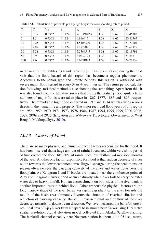
Table 13.6 Calculation of probable peak gauge height for corresponding return period
T
Y t
Ӯn
∂ n
k t
S x
X̄
X t
2
0.37
0.5362
1.1124
−0.1494067
1.38
19.67
19.46382
5
1.5
0.5362
1.1124
0.866415
1.38
19.67
20.86565
10
2.25
0.5362
1.1124
1.5406329
1.38
19.67
21.79607
20
2.97
0.5362
1.1124
2.1878821
1.38
19.67
22.68928
30
3.38
0.5362
1.1124
2.5564545
1.38
19.67
23.19791
50
3.9
0.5362
1.1124
3.0239123
1.38
19.67
23.843
100
4.6
0.5362
1.1124
3.6531823
1.38
19.67
24.71139
in the near future (Tables 13.4 and Table 13.6). It has been noticed during the field
visit that the flood hazard of this region has become a regular phenomenon.
According to the senior-aged and literate persons, this region is witnessed with
severe major flood hazard in every 3- or 4-year interval. The return period calculation following statistical method is also showing the same thing. Apart from this, it
was also found from the literature survey that during the British period, quite a large
numbers of major floods were taken place in 1867, 1877, 1885 and 1896, respectively. The remarkable high flood occurred in 1913 and 1914 which causes serious
threats to the human life and property. The major recorded flood years of this region
are 1956, 1959, 1970, 1971, 1973, 1978, 1984, 1987, 1994, 1995, 1999, 2000, 2006,
2007, 2009 and 2015 (Irrigation and Waterways Directorate, Government of West
Bengal; Mukhopadhyay 2010).
13.4.3 Causes of Flood
There are so many physical and human-induced factors responsible for the flood. It
has been observed that a huge amount of rainfall occurred within very short period
of time creates the flood, like 80% of rainfall occurred within 3–4 monsoon months
of the year. Another one factor responsible for flood is that sudden decrease of river
width towards the lower catchment area. Huge discharge during the peak monsoon
season often exceeds the carrying capacity of the river and water flows over the
floodplain. As Ketugram-I and II blocks are located near the confluence point of
Ajay and Bhagirathi rivers, flood occurs naturally when river fails to carry the extra
water due to heavy rainfall. Human encroachment on both sides of the river bank is
another important reason behind flood. Other responsible physical factors are the
long, narrow shape of the river basin, very gentle gradient of the river towards the
mouth of the basin area ultimately favours the situation of riverbed siltation and
reduction of carrying capacity. Bankfull cross-sectional area of flow of the river
decreases towards its downstream direction. We have measured the bankfull crosssectional area of Ajay River from Noapara to its mouth near Katwa using 12.5 metre
spatial resolution digital elevation model collected from Alaska Satellite Facility.
The bankfull channel capacity near Noapara station is about 1114.051 sq. metre,
13 Flood Frequency Analysis and Its Management in Selected Part of Bardham…
Table 13.6 Calculation of probable peak gauge height for corresponding return period
T
Y t
Ӯn
∂ n
k t
S x
X̄
X t
2
0.37
0.5362
1.1124
−0.1494067
1.38
19.67
19.46382
5
1.5
0.5362
1.1124
0.866415
1.38
19.67
20.86565
10
2.25
0.5362
1.1124
1.5406329
1.38
19.67
21.79607
20
2.97
0.5362
1.1124
2.1878821
1.38
19.67
22.68928
30
3.38
0.5362
1.1124
2.5564545
1.38
19.67
23.19791
50
3.9
0.5362
1.1124
3.0239123
1.38
19.67
23.843
100
4.6
0.5362
1.1124
3.6531823
1.38
19.67
24.71139
in the near future (Tables 13.4 and Table 13.6). It has been noticed during the field
visit that the flood hazard of this region has become a regular phenomenon.
According to the senior-aged and literate persons, this region is witnessed with
severe major flood hazard in every 3- or 4-year interval. The return period calculation following statistical method is also showing the same thing. Apart from this, it
was also found from the literature survey that during the British period, quite a large
numbers of major floods were taken place in 1867, 1877, 1885 and 1896, respectively. The remarkable high flood occurred in 1913 and 1914 which causes serious
threats to the human life and property. The major recorded flood years of this region
are 1956, 1959, 1970, 1971, 1973, 1978, 1984, 1987, 1994, 1995, 1999, 2000, 2006,
2007, 2009 and 2015 (Irrigation and Waterways Directorate, Government of West
Bengal; Mukhopadhyay 2010).
13.4.3 Causes of Flood
There are so many physical and human-induced factors responsible for the flood. It
has been observed that a huge amount of rainfall occurred within very short period
of time creates the flood, like 80% of rainfall occurred within 3–4 monsoon months
of the year. Another one factor responsible for flood is that sudden decrease of river
width towards the lower catchment area. Huge discharge during the peak monsoon
season often exceeds the carrying capacity of the river and water flows over the
floodplain. As Ketugram-I and II blocks are located near the confluence point of
Ajay and Bhagirathi rivers, flood occurs naturally when river fails to carry the extra
water due to heavy rainfall. Human encroachment on both sides of the river bank is
another important reason behind flood. Other responsible physical factors are the
long, narrow shape of the river basin, very gentle gradient of the river towards the
mouth of the basin area ultimately favours the situation of riverbed siltation and
reduction of carrying capacity. Bankfull cross-sectional area of flow of the river
decreases towards its downstream direction. We have measured the bankfull crosssectional area of Ajay River from Noapara to its mouth near Katwa using 12.5 metre
spatial resolution digital elevation model collected from Alaska Satellite Facility.
The bankfull channel capacity near Noapara station is about 1114.051 sq. metre,
13 Flood Frequency Analysis and Its Management in Selected Part of Bardham…