

83
The fragmentation maps that were prepared shows six fragmentation classes that
includes classes such as patch, edge, perforated, core I (<0.5 km), core II (1–2 km)
and core III (>2 km). The results revealed that fragmented forest patches increased
in area from 16.72% in 1990 to 26.81% in 2018, the edge forests also showed an
increase in area from 23.34% in 1990 to 28.12% in 2018; perforated forests showed
a decrease in area from 28.69% in 1990 to 24.88% in 2018 and decrease in core I
area (<1 km) from 5.33% in 1990 to 4.57% in 2018; also, there was an increase in
core II area (1–2 km) from 1.11% in 1990 to 1.24% in 2018 and decrease in core III
area (>2 km) from 24.78% in 1990 to 14.39% in 2018. Also, it was observed that the
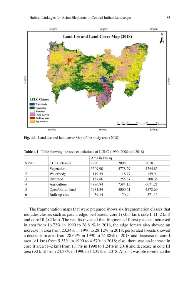
Fig. 4.6 Land use and land cover Map of the study area (2018)
Table 4.1 Table showing the area calculations of LULC (1990, 2008 and 2018)
S.NO.
LULC classes
Area in km sq.
1990
2008
2018
1
Vegetation
5309.90
4778.29
4744.85
2
Waterbody
119.55
118.77
159.9
3
Riverbed
157.86
255.37
108.35
4
Agriculture
4996.84
7384.15
6671.21
5
Open/barren land
5931.34
4000.61
4578.69
6
Built-up area
59.14
70.9
271.13
4 Habitat Linkages for Asian Elephants in Central Indian Landscape
The fragmentation maps that were prepared shows six fragmentation classes that
includes classes such as patch, edge, perforated, core I (<0.5 km), core II (1–2 km)
and core III (>2 km). The results revealed that fragmented forest patches increased
in area from 16.72% in 1990 to 26.81% in 2018, the edge forests also showed an
increase in area from 23.34% in 1990 to 28.12% in 2018; perforated forests showed
a decrease in area from 28.69% in 1990 to 24.88% in 2018 and decrease in core I
area (<1 km) from 5.33% in 1990 to 4.57% in 2018; also, there was an increase in
core II area (1–2 km) from 1.11% in 1990 to 1.24% in 2018 and decrease in core III
area (>2 km) from 24.78% in 1990 to 14.39% in 2018. Also, it was observed that the
Fig. 4.6 Land use and land cover Map of the study area (2018)
Table 4.1 Table showing the area calculations of LULC (1990, 2008 and 2018)
S.NO.
LULC classes
Area in km sq.
1990
2008
2018
1
Vegetation
5309.90
4778.29
4744.85
2
Waterbody
119.55
118.77
159.9
3
Riverbed
157.86
255.37
108.35
4
Agriculture
4996.84
7384.15
6671.21
5
Open/barren land
5931.34
4000.61
4578.69
6
Built-up area
59.14
70.9
271.13
4 Habitat Linkages for Asian Elephants in Central Indian Landscape