

epipedon is the most frequently occurring diagnostic surface
horizon (83%), followed by the mollic and histic (8% each),
and umbric (1%) (Table 3.3). The histic epipedon is the
thickest surface horizon at 82 cm, followed by the umbric
(29 cm), mollic (28 cm), and ochric (20 cm).
Diagnostic subsurface horizons are defined primarily on
the basis of the accumulation of specific weathering products, such as silicate clays, Ca, Si, Fe and Al oxyhydroxides;
cementation; bleaching; mixing; and human disturbances. Of
the 20 diagnostic subsurface horizons, eight are present in
Great Lakes soils, including from most to least, the argillic
horizon (accumulation of clay), albic horizon (bleaching of
sand and silt grains), cambic horizon (minimal development
of color and/or structure), spodic horizon (accumulation of
Fe and Al oxyhydroxides complexed with organic C), and
glossic horizons (tonguing in E and Bt in degrading argillic
horizons) (Table 3.3). Less common are soils with fragipans
(reversibly cemented based on soil moisture content), and
ortstein (cemented by Fe oxyhydroxides). The fragipan tends
to be the thickest diagnostic subsurface horizon at 60 cm,
followed by the argillic (51 cm), cambic (47 cm), glossic
(33 cm), ortstein (26 cm), and albic (24 cm). Soils of the
Great Lakes contain one epipedon and 1.4 ± 1.2 subsurface
horizons. Some soil series contain as many as five diagnostic
subsurface horizons, including the Frohling, Gogebic, Skanee, Tokiahok, and Yalmer.
3.3.3 Constructing a Soil Name
Soil series bear a name that often recognizes its type location, e.g., Gogebic from Lake Gogebic in the Upper
Peninsula of Michigan. Taxonomic names are constructed
from abbreviations taken generally from the first vowel and
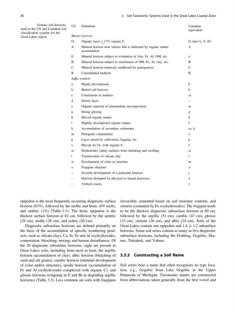
Table 3.1 Genetic soil horizons
used in the US and Canadian soil
classification systems for the
Great Lakes region
US
Definition
Canadian
equivalent
Master horizon
O
Organic layer > 17% organic C
O (also L, F, H)
A
Mineral horizon near surface that is darkened by organic matter
accumulation
A
E
Mineral horizon subject to evaluation of clay, Fe, Al, OM, etc.
e
B
Mineral horizon subject to enrichment of OM, Fe, Al, clay, etc.
B
C
Mineral horizon relatively unaffected by pedogenesis
C
R
Consolidated bedrock
R
Suffix symbols
a
Highly decomposed
h
b
Buried soil horizon
b
c
Concretions or nodules
cc
d
Densic layer
–
e
Organic material of intermediate decomposition
m
g
Strong gleying
g
h
Illuvial organic matter
h
i
Slightly decomposed organic matter
f
k
Accumulation of secondary carbonates
ca, k
m
Pedogenic cementation
c
p
Layer mixed by cultivation, logging, etc.
p
s
Illuvial Al, Fe, with organic C
f
ss
Slickensides (shiny surfaces from shrinking and swelling
ss
t
Translocation of silicate clay
t
w
Development of color or structure
m
x
Fragipan character
x
–
Juvenile development of a particular horizon
j
–
Horizon disrupted by physical or faunal processes
u
–
Vertical cracks
v
36
3 Soil Taxonomic Systems Used in the Great Lakes Coastal Zone
horizon (83%), followed by the mollic and histic (8% each),
and umbric (1%) (Table 3.3). The histic epipedon is the
thickest surface horizon at 82 cm, followed by the umbric
(29 cm), mollic (28 cm), and ochric (20 cm).
Diagnostic subsurface horizons are defined primarily on
the basis of the accumulation of specific weathering products, such as silicate clays, Ca, Si, Fe and Al oxyhydroxides;
cementation; bleaching; mixing; and human disturbances. Of
the 20 diagnostic subsurface horizons, eight are present in
Great Lakes soils, including from most to least, the argillic
horizon (accumulation of clay), albic horizon (bleaching of
sand and silt grains), cambic horizon (minimal development
of color and/or structure), spodic horizon (accumulation of
Fe and Al oxyhydroxides complexed with organic C), and
glossic horizons (tonguing in E and Bt in degrading argillic
horizons) (Table 3.3). Less common are soils with fragipans
(reversibly cemented based on soil moisture content), and
ortstein (cemented by Fe oxyhydroxides). The fragipan tends
to be the thickest diagnostic subsurface horizon at 60 cm,
followed by the argillic (51 cm), cambic (47 cm), glossic
(33 cm), ortstein (26 cm), and albic (24 cm). Soils of the
Great Lakes contain one epipedon and 1.4 ± 1.2 subsurface
horizons. Some soil series contain as many as five diagnostic
subsurface horizons, including the Frohling, Gogebic, Skanee, Tokiahok, and Yalmer.
3.3.3 Constructing a Soil Name
Soil series bear a name that often recognizes its type location, e.g., Gogebic from Lake Gogebic in the Upper
Peninsula of Michigan. Taxonomic names are constructed
from abbreviations taken generally from the first vowel and
Table 3.1 Genetic soil horizons
used in the US and Canadian soil
classification systems for the
Great Lakes region
US
Definition
Canadian
equivalent
Master horizon
O
Organic layer > 17% organic C
O (also L, F, H)
A
Mineral horizon near surface that is darkened by organic matter
accumulation
A
E
Mineral horizon subject to evaluation of clay, Fe, Al, OM, etc.
e
B
Mineral horizon subject to enrichment of OM, Fe, Al, clay, etc.
B
C
Mineral horizon relatively unaffected by pedogenesis
C
R
Consolidated bedrock
R
Suffix symbols
a
Highly decomposed
h
b
Buried soil horizon
b
c
Concretions or nodules
cc
d
Densic layer
–
e
Organic material of intermediate decomposition
m
g
Strong gleying
g
h
Illuvial organic matter
h
i
Slightly decomposed organic matter
f
k
Accumulation of secondary carbonates
ca, k
m
Pedogenic cementation
c
p
Layer mixed by cultivation, logging, etc.
p
s
Illuvial Al, Fe, with organic C
f
ss
Slickensides (shiny surfaces from shrinking and swelling
ss
t
Translocation of silicate clay
t
w
Development of color or structure
m
x
Fragipan character
x
–
Juvenile development of a particular horizon
j
–
Horizon disrupted by physical or faunal processes
u
–
Vertical cracks
v
36
3 Soil Taxonomic Systems Used in the Great Lakes Coastal Zone