

Lupton, Tawas, and Markey) are common in swales of the
beach ridges and in sandy depressions (Fig. 7.9). The
Wainola soil series is a Typic Endoaquods derived from fine
sandy glaciofluvial deposits on lake plains (Fig. 7.10). The
Wainola soil profile contains a black Oa to 2 in. (5 cm), a
pinkish gray E horizon to 10 in. (25 cm), a reddish brown
Bhs to 12 in. (30 cm), and strong brown and reddish brown
Bs horizons to 32 in. (81 cm). The material below 32 in.
(81 cm) has massed of oxidized Fe throughout. The Au Gres
is shown in Fig. 5.7A.
The fourth segment along Lake Michigan is part of
MLRA 96, the Western Michigan Fruit Belt and extends
from Mackinaw City down the eastern shore to Manistee,
Michigan. This segment is a highly dissected sandy loam till
plain with abundant drumlins that is fringed in places by
beach ridges and dunes (Fig. 7.11). The till plain contains
mainly Haplorthods (East Lake, Kalkaska, and Leelanau soil
series) and Hapludalfs (Emmet). The Pipestone soil series
(Endoaquods) has developed in water-worked till plains and
contains a very dark brown A horizon to 8 in. (20 cm), a
grayish brown E horizon to 10 in. (25 cm), a dark reddish
brown Bhs horizon to 14 in. (35 cm), and a yellowish brown
Bs horizon to 31 in. (80 cm) (Fig. 7.12; note: the scale is
upside down). Stable dunes and beach ridges feature Udipsamments (Deer Park and Eastport soil series), Quartzipsamments (Nordhouse), and Hapludalfs (Spinks). The
Spinks soil series is a Lamellic Hapludalfs formed in sandy
outwash (Fig. 7.13). The Spinks profile contains a brownish
A horizon to the top of the shovel handle, a yellowish brown
Bw horizon to the first lamella, and a series of lamellae (E
and Bt horizon) to more than 2 m (below the base of the
photo). The Kalkaska and Deer Park soil series were shown
in Figs. 5.6B and 5.17 upper, left), respectively.
The fifth segment extends along the eastern shore of Lake
Michigan from Manistee to Muskegon, Michigan. This
segment contains primarily sandy loam till and lacustrine
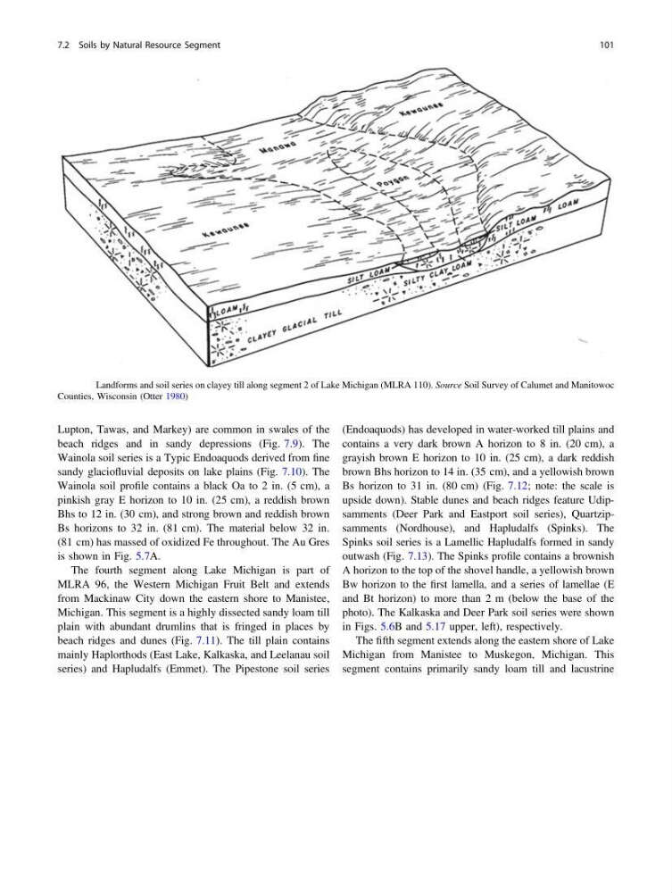
Fig. 7.3 Landforms and soil series on clayey till along segment 2 of Lake Michigan (MLRA 110). Source Soil Survey of Calumet and Manitowoc
Counties, Wisconsin (Otter 1980)
7.2 Soils by Natural Resource Segment
101
beach ridges and in sandy depressions (Fig. 7.9). The
Wainola soil series is a Typic Endoaquods derived from fine
sandy glaciofluvial deposits on lake plains (Fig. 7.10). The
Wainola soil profile contains a black Oa to 2 in. (5 cm), a
pinkish gray E horizon to 10 in. (25 cm), a reddish brown
Bhs to 12 in. (30 cm), and strong brown and reddish brown
Bs horizons to 32 in. (81 cm). The material below 32 in.
(81 cm) has massed of oxidized Fe throughout. The Au Gres
is shown in Fig. 5.7A.
The fourth segment along Lake Michigan is part of
MLRA 96, the Western Michigan Fruit Belt and extends
from Mackinaw City down the eastern shore to Manistee,
Michigan. This segment is a highly dissected sandy loam till
plain with abundant drumlins that is fringed in places by
beach ridges and dunes (Fig. 7.11). The till plain contains
mainly Haplorthods (East Lake, Kalkaska, and Leelanau soil
series) and Hapludalfs (Emmet). The Pipestone soil series
(Endoaquods) has developed in water-worked till plains and
contains a very dark brown A horizon to 8 in. (20 cm), a
grayish brown E horizon to 10 in. (25 cm), a dark reddish
brown Bhs horizon to 14 in. (35 cm), and a yellowish brown
Bs horizon to 31 in. (80 cm) (Fig. 7.12; note: the scale is
upside down). Stable dunes and beach ridges feature Udipsamments (Deer Park and Eastport soil series), Quartzipsamments (Nordhouse), and Hapludalfs (Spinks). The
Spinks soil series is a Lamellic Hapludalfs formed in sandy
outwash (Fig. 7.13). The Spinks profile contains a brownish
A horizon to the top of the shovel handle, a yellowish brown
Bw horizon to the first lamella, and a series of lamellae (E
and Bt horizon) to more than 2 m (below the base of the
photo). The Kalkaska and Deer Park soil series were shown
in Figs. 5.6B and 5.17 upper, left), respectively.
The fifth segment extends along the eastern shore of Lake
Michigan from Manistee to Muskegon, Michigan. This
segment contains primarily sandy loam till and lacustrine
Fig. 7.3 Landforms and soil series on clayey till along segment 2 of Lake Michigan (MLRA 110). Source Soil Survey of Calumet and Manitowoc
Counties, Wisconsin (Otter 1980)
7.2 Soils by Natural Resource Segment
101