

206
(1.2–3 m) above normal water levels. The winds and storm surge had a major impact
on Florida Bay and our four islands, especially the western-most island (Jim Foot
Key), closest to the storm path. We could now view first-hand what the storm had
done to the islands we had studied and sampled extensively in 2014.
Although I’ve been in Florida following other hurricanes, I wasn’t prepared for
what we saw as our boat approached Jim Foot Key. The island looked very different.
The eastern edge of Jim Foot had barely a leaf left on a tree where a thick stand of
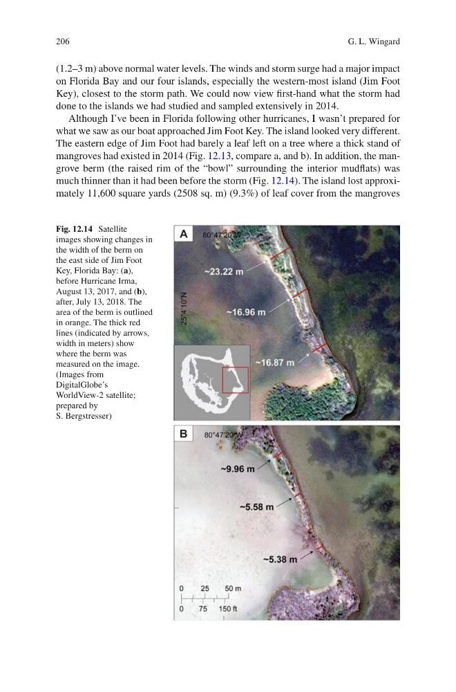
mangroves had existed in 2014 (Fig. 12.13, compare a, and b). In addition, the mangrove berm (the raised rim of the “bowl” surrounding the interior mudflats) was
much thinner than it had been before the storm (Fig. 12.14). The island lost approximately 11,600 square yards (2508 sq. m) (9.3%) of leaf cover from the mangroves
Fig. 12.14 Satellite
images showing changes in
the width of the berm on
the east side of Jim Foot
Key, Florida Bay: (a),
before Hurricane Irma,
August 13, 2017, and (b),
after, July 13, 2018. The
area of the berm is outlined
in orange. The thick red
lines (indicated by arrows,
width in meters) show
where the berm was
measured on the image.
(Images from
DigitalGlobe’s
WorldView-2 satellite;
prepared by
S. Bergstresser)
G. L. Wingard
(1.2–3 m) above normal water levels. The winds and storm surge had a major impact
on Florida Bay and our four islands, especially the western-most island (Jim Foot
Key), closest to the storm path. We could now view first-hand what the storm had
done to the islands we had studied and sampled extensively in 2014.
Although I’ve been in Florida following other hurricanes, I wasn’t prepared for
what we saw as our boat approached Jim Foot Key. The island looked very different.
The eastern edge of Jim Foot had barely a leaf left on a tree where a thick stand of
mangroves had existed in 2014 (Fig. 12.13, compare a, and b). In addition, the mangrove berm (the raised rim of the “bowl” surrounding the interior mudflats) was
much thinner than it had been before the storm (Fig. 12.14). The island lost approximately 11,600 square yards (2508 sq. m) (9.3%) of leaf cover from the mangroves
Fig. 12.14 Satellite
images showing changes in
the width of the berm on
the east side of Jim Foot
Key, Florida Bay: (a),
before Hurricane Irma,
August 13, 2017, and (b),
after, July 13, 2018. The
area of the berm is outlined
in orange. The thick red
lines (indicated by arrows,
width in meters) show
where the berm was
measured on the image.
(Images from
DigitalGlobe’s
WorldView-2 satellite;
prepared by
S. Bergstresser)
G. L. Wingard