

175
The Initial Soggy Groggys
In the 1960s and 1970s, little detail was known about rising sea level, storm dynamics, and coastal evolution. In order to understand these processes, our students
involved in the “ECU by the Sea” program formed research teams and went out into
the field on what became known as “soggy groggys”. The teams followed the rapidly changing weather conditions such as storms and analyzed real world coastal
responses to those changes. Each soggy groggy continued around the clock, sometimes for days, until a storm abated. Wet, cold, hungry, and tired we learned about
energy, water flow, and sediment transport; we learned how inlets grow and shrink,
how beaches build and recede, and barrier islands migrate. And most importantly,
we learned how the cumulative impacts of a series of storms change the
coastal system.
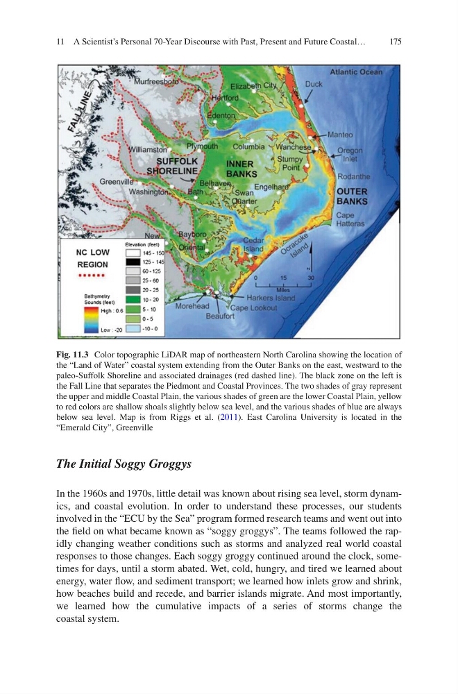
Fig. 11.3 Color topographic LiDAR map of northeastern North Carolina showing the location of
the “Land of Water” coastal system extending from the Outer Banks on the east, westward to the
paleo-Suffolk Shoreline and associated drainages (red dashed line). The black zone on the left is
the Fall Line that separates the Piedmont and Coastal Provinces. The two shades of gray represent
the upper and middle Coastal Plain, the various shades of green are the lower Coastal Plain, yellow
to red colors are shallow shoals slightly below sea level, and the various shades of blue are always
below sea level. Map is from Riggs et al. (2011). East Carolina University is located in the
“Emerald City”, Greenville
11 A Scientist’s Personal 70-Year Discourse with Past, Present and Future Coastal…
The Initial Soggy Groggys
In the 1960s and 1970s, little detail was known about rising sea level, storm dynamics, and coastal evolution. In order to understand these processes, our students
involved in the “ECU by the Sea” program formed research teams and went out into
the field on what became known as “soggy groggys”. The teams followed the rapidly changing weather conditions such as storms and analyzed real world coastal
responses to those changes. Each soggy groggy continued around the clock, sometimes for days, until a storm abated. Wet, cold, hungry, and tired we learned about
energy, water flow, and sediment transport; we learned how inlets grow and shrink,
how beaches build and recede, and barrier islands migrate. And most importantly,
we learned how the cumulative impacts of a series of storms change the
coastal system.
Fig. 11.3 Color topographic LiDAR map of northeastern North Carolina showing the location of
the “Land of Water” coastal system extending from the Outer Banks on the east, westward to the
paleo-Suffolk Shoreline and associated drainages (red dashed line). The black zone on the left is
the Fall Line that separates the Piedmont and Coastal Provinces. The two shades of gray represent
the upper and middle Coastal Plain, the various shades of green are the lower Coastal Plain, yellow
to red colors are shallow shoals slightly below sea level, and the various shades of blue are always
below sea level. Map is from Riggs et al. (2011). East Carolina University is located in the
“Emerald City”, Greenville
11 A Scientist’s Personal 70-Year Discourse with Past, Present and Future Coastal…