

140
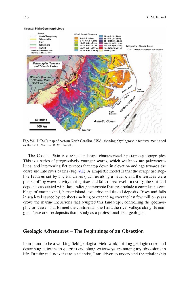
The Coastal Plain is a relict landscape characterized by stairstep topography.
This is a series of progressively younger scarps, which we know are paleoshorelines, and intervening flat terraces that step down in elevation and age towards the
coast and into river basins (Fig. 9.1). A simplistic model is that the scarps are steplike features cut by ancient waves (such as along a beach), and the terraces were
planed off by wave activity during rises and falls of sea level. In reality, the surficial
deposits associated with these relict geomorphic features include a complex assemblage of marine shelf, barrier island, estuarine and fluvial deposits. Rises and falls
in sea level caused by ice sheets melting or expanding over the last few million years
drove the marine incursions that sculpted this landscape, controlling the geomorphic processes that formed the continental shelf and the river valleys along its margin. These are the deposits that I study as a professional field geologist.
Geologic Adventures – The Beginnings of an Obsession
I am proud to be a working field geologist. Field work, drilling geologic cores and
describing outcrops in quarries and along waterways are among my obsessions in
life. But the reality is that as a scientist, I am driven to understand the relationship
Fig. 9.1 LiDAR map of eastern North Carolina, USA, showing physiographic features mentioned
in the text. (Source: K.M. Farrell)
K. M. Farrell
The Coastal Plain is a relict landscape characterized by stairstep topography.
This is a series of progressively younger scarps, which we know are paleoshorelines, and intervening flat terraces that step down in elevation and age towards the
coast and into river basins (Fig. 9.1). A simplistic model is that the scarps are steplike features cut by ancient waves (such as along a beach), and the terraces were
planed off by wave activity during rises and falls of sea level. In reality, the surficial
deposits associated with these relict geomorphic features include a complex assemblage of marine shelf, barrier island, estuarine and fluvial deposits. Rises and falls
in sea level caused by ice sheets melting or expanding over the last few million years
drove the marine incursions that sculpted this landscape, controlling the geomorphic processes that formed the continental shelf and the river valleys along its margin. These are the deposits that I study as a professional field geologist.
Geologic Adventures – The Beginnings of an Obsession
I am proud to be a working field geologist. Field work, drilling geologic cores and
describing outcrops in quarries and along waterways are among my obsessions in
life. But the reality is that as a scientist, I am driven to understand the relationship
Fig. 9.1 LiDAR map of eastern North Carolina, USA, showing physiographic features mentioned
in the text. (Source: K.M. Farrell)
K. M. Farrell