

105
Motion, images from different angles are stitched together using computer- identified
common points: decimeter-scale horizontal and vertical topographic variations can
be seen. In some ongoing research, my ECU colleague Dr. David Lagomasino and
I are using aerial drone and boat-based acoustic and video observations to groundtruth habitat large-scale mapping with satellite imagery in the Philippines (see
Lagomasino chapter). This work is part of the USAID Fish Right Program to help
communities and agencies better manage fish resources.
We now have amazingly capable drones and other vehicles for mapping from the
water surface and below it. For example, remotely controlled jet-driven kayaks or
other boats can measure water properties and image seafloor areas with echosounders, including multibeam. Even more impressive are fully autonomous underwater
vehicles that can survey large areas of the seafloor and inaccessible locations (e.g.,
under glaciers) to not only determine the shape of the seafloor, sometimes called the
“seascape”, but also what lives on it. Several exciting AUV examples competed for
the aforementioned Shell Ocean Discovery Xprize. To see what is possible
today, Figure 6.9 is an image from HabCam (https://habcam.whoi.edu/) a towed
benthic habitat mapper being used by NOAA to quantify scallop and other demersal
life on continental margins. The latest version of HabCam is an AUV system.
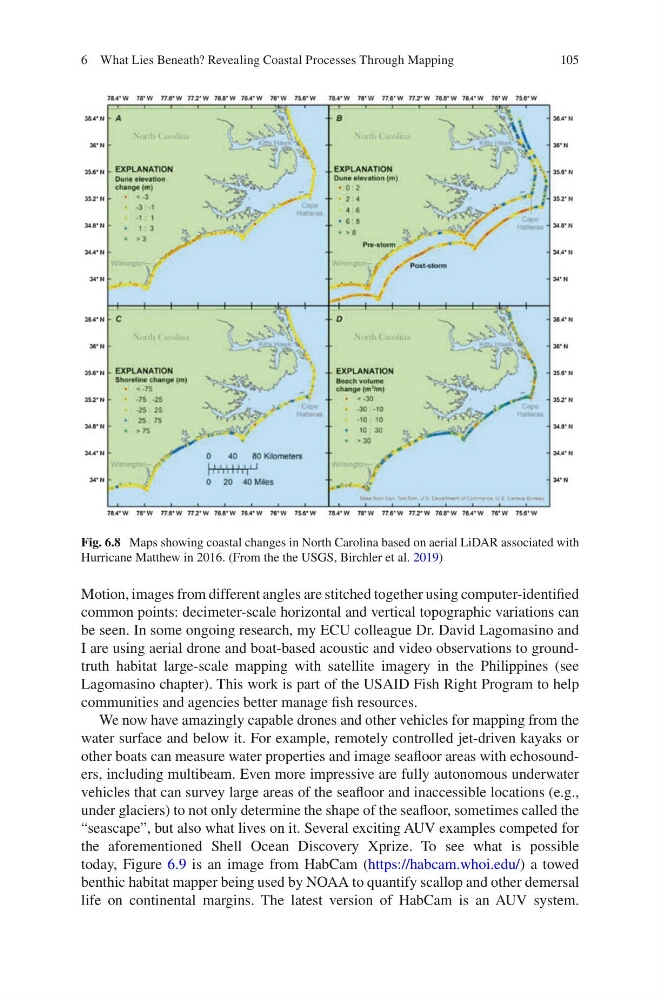
Fig. 6.8 Maps showing coastal changes in North Carolina based on aerial LiDAR associated with
Hurricane Matthew in 2016. (From the the USGS, Birchler et al. 2019)
6 What Lies Beneath? Revealing Coastal Processes Through Mapping
Motion, images from different angles are stitched together using computer- identified
common points: decimeter-scale horizontal and vertical topographic variations can
be seen. In some ongoing research, my ECU colleague Dr. David Lagomasino and
I are using aerial drone and boat-based acoustic and video observations to groundtruth habitat large-scale mapping with satellite imagery in the Philippines (see
Lagomasino chapter). This work is part of the USAID Fish Right Program to help
communities and agencies better manage fish resources.
We now have amazingly capable drones and other vehicles for mapping from the
water surface and below it. For example, remotely controlled jet-driven kayaks or
other boats can measure water properties and image seafloor areas with echosounders, including multibeam. Even more impressive are fully autonomous underwater
vehicles that can survey large areas of the seafloor and inaccessible locations (e.g.,
under glaciers) to not only determine the shape of the seafloor, sometimes called the
“seascape”, but also what lives on it. Several exciting AUV examples competed for
the aforementioned Shell Ocean Discovery Xprize. To see what is possible
today, Figure 6.9 is an image from HabCam (https://habcam.whoi.edu/) a towed
benthic habitat mapper being used by NOAA to quantify scallop and other demersal
life on continental margins. The latest version of HabCam is an AUV system.
Fig. 6.8 Maps showing coastal changes in North Carolina based on aerial LiDAR associated with
Hurricane Matthew in 2016. (From the the USGS, Birchler et al. 2019)
6 What Lies Beneath? Revealing Coastal Processes Through Mapping