

potential arable use limits the ability for current and future
generations to undertake arable production on land most
suitable and sustainable for food production. The loss of the
relatively rare LUC 1 land, and the scarce LUC 2 land, also
contradicts the desirability to maintain soil and biodiversity
and to preserve soil ecosystems. Conserving representatives
of all our soils, as taonga, could also be considered in much
in the same way as kiwi and kauri are treasured and
preserved.
It is no coincidence that much of the most productive land
is adjacent to our most rapidly growing cities. Yet there are
plenty of less versatile soils available for housing.
Around 36% of New Zealand comprises rolling (7–15°)
and hilly (15–25°) lands which are typically suitable for
supporting permanent pasture and sheep and cattle grazing,
but which are generally not suitable for intensive crop production for the most important foods such as wheat, corn,
potatoes, and other fruits and vegetables. Only *54% of
New Zealand’s soils can sustain agriculture as the balance is
steep, erosion prone LUC 7 and 8 lands which are better
utilised for protection forestry (Fig. 18.8).
Thus, if roads, buildings, and other permanent sealed
features, are allowed to continually expand over the 5% or so
of New Zealand that is ideally suited, for intensive cropping
and horticultural production, there will be no suitable alternative areas in New Zealand to support such food production. Already more than 10% of the highly productive LUC
class 1 and 2 soils of New Zealand have been converted into
lifestyle blocks and urbanisation (Fig. 18.9). The Ministry
for the Environment and NZ Stats reported, in 2019, that in
the Waikato and Auckland areas about 35% of highly productive land is now lost to lifestyle blocks and urbanisation.
The National Policy Statement that is currently under
consideration is likely to lead to all councils having to
implement measures to protect soils of high value for food
production. However, the planning processes that may lead
to such implementation are slow, protections can be ‘got
around’, and in the meantime urban motorway, industrial,
and housing areas, are rapidly expanding onto high-class
soils in a number of regions.
18.4.12 Soil Security—The Future of Land
Evaluation?
Alex McBratney and collaborators have summarised the
challenges faced by soil science to ‘secure’ our soils. Five
dimensions of soil security have been articulated: capability,
condition, capital, connectivity, and codification. The concept of soil security seeks to combine land evaluation
methods with concepts of sustainable land management. The
five dimensions are described in more detail below.
1. Capability of the soil/land encompasses the
well-established LUC assessment (Sect. 18.4.4) along
with land use suitability assessment methods
(Sect. 18.4.5). Soil vulnerability (Sect. 18.4.7) could also
be included in an assessment of capability.
2. Condition of the soil/land is encapsulated by identifying
a set of soil quality indicators that allow monitoring and
assessment of the functioning of soils and ecosystems in
sustaining life (Sect. 18.4.8).
3. Capital is the value of soil natural capital and ecosystem
services (Sect. 18.4.9). A goal is to express soil capital
values in monetary terms but technical and acceptability
issues need to be overcome. However, alternative,
non-monetary, means are available employing indices or
soil function output values, and the Ministry of Primary
Industries has recognised the role of soil in terms of
natural capital within the developing National Policy
Statement on high-class soils.
4. Connectivity is the linkage of soil information and land
management decision making, including monitoring
systems. In New Zealand a precursor of what this might
become is provided by the linkage of S-map outputs
(Sect. 18.4.3) to the Overseer nutrient management
model.
5. Codification is the adoption of soil data into policies to
influence decision making in the choices of how land is
managed and in the design of sustainable landscapes. For
example, the LUC classification, or an adaptation of it,
has potential to guide decision making on which areas of
land should be protected from urban development, and
the Overseer model has potential to be used to guide
decisions about fertiliser application. However, great
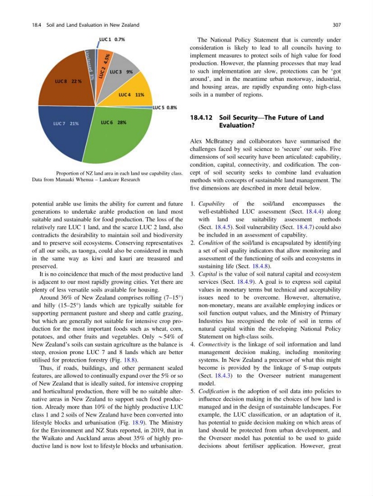
Fig. 18.7 Proportion of NZ land area in each land use capability class.
Data from Manaaki Whenua – Landcare Research
18.4 Soil and Land Evaluation in New Zealand
307
generations to undertake arable production on land most
suitable and sustainable for food production. The loss of the
relatively rare LUC 1 land, and the scarce LUC 2 land, also
contradicts the desirability to maintain soil and biodiversity
and to preserve soil ecosystems. Conserving representatives
of all our soils, as taonga, could also be considered in much
in the same way as kiwi and kauri are treasured and
preserved.
It is no coincidence that much of the most productive land
is adjacent to our most rapidly growing cities. Yet there are
plenty of less versatile soils available for housing.
Around 36% of New Zealand comprises rolling (7–15°)
and hilly (15–25°) lands which are typically suitable for
supporting permanent pasture and sheep and cattle grazing,
but which are generally not suitable for intensive crop production for the most important foods such as wheat, corn,
potatoes, and other fruits and vegetables. Only *54% of
New Zealand’s soils can sustain agriculture as the balance is
steep, erosion prone LUC 7 and 8 lands which are better
utilised for protection forestry (Fig. 18.8).
Thus, if roads, buildings, and other permanent sealed
features, are allowed to continually expand over the 5% or so
of New Zealand that is ideally suited, for intensive cropping
and horticultural production, there will be no suitable alternative areas in New Zealand to support such food production. Already more than 10% of the highly productive LUC
class 1 and 2 soils of New Zealand have been converted into
lifestyle blocks and urbanisation (Fig. 18.9). The Ministry
for the Environment and NZ Stats reported, in 2019, that in
the Waikato and Auckland areas about 35% of highly productive land is now lost to lifestyle blocks and urbanisation.
The National Policy Statement that is currently under
consideration is likely to lead to all councils having to
implement measures to protect soils of high value for food
production. However, the planning processes that may lead
to such implementation are slow, protections can be ‘got
around’, and in the meantime urban motorway, industrial,
and housing areas, are rapidly expanding onto high-class
soils in a number of regions.
18.4.12 Soil Security—The Future of Land
Evaluation?
Alex McBratney and collaborators have summarised the
challenges faced by soil science to ‘secure’ our soils. Five
dimensions of soil security have been articulated: capability,
condition, capital, connectivity, and codification. The concept of soil security seeks to combine land evaluation
methods with concepts of sustainable land management. The
five dimensions are described in more detail below.
1. Capability of the soil/land encompasses the
well-established LUC assessment (Sect. 18.4.4) along
with land use suitability assessment methods
(Sect. 18.4.5). Soil vulnerability (Sect. 18.4.7) could also
be included in an assessment of capability.
2. Condition of the soil/land is encapsulated by identifying
a set of soil quality indicators that allow monitoring and
assessment of the functioning of soils and ecosystems in
sustaining life (Sect. 18.4.8).
3. Capital is the value of soil natural capital and ecosystem
services (Sect. 18.4.9). A goal is to express soil capital
values in monetary terms but technical and acceptability
issues need to be overcome. However, alternative,
non-monetary, means are available employing indices or
soil function output values, and the Ministry of Primary
Industries has recognised the role of soil in terms of
natural capital within the developing National Policy
Statement on high-class soils.
4. Connectivity is the linkage of soil information and land
management decision making, including monitoring
systems. In New Zealand a precursor of what this might
become is provided by the linkage of S-map outputs
(Sect. 18.4.3) to the Overseer nutrient management
model.
5. Codification is the adoption of soil data into policies to
influence decision making in the choices of how land is
managed and in the design of sustainable landscapes. For
example, the LUC classification, or an adaptation of it,
has potential to guide decision making on which areas of
land should be protected from urban development, and
the Overseer model has potential to be used to guide
decisions about fertiliser application. However, great
Fig. 18.7 Proportion of NZ land area in each land use capability class.
Data from Manaaki Whenua – Landcare Research
18.4 Soil and Land Evaluation in New Zealand
307