

detailed surveys of soil and erosion throughout the country.
Soil erosion had become a topic of growing concern following a series of major erosion and flood events on the east
coast of North Island in the 1930s. The findings of early
erosion surveys by Harry Gibbs and Grange, critical of farm
management in places, were highly contentious. However, in
1941, the Soil Conservation and Rivers Control Act was
passed. The act defined catchment districts and associated
catchment boards were established to prevent or minimise
damage from floods and erosion. By 1945, 11 catchment
boards had been formed, and by 1967 the entire New Zealand
landscape was covered. The catchment boards eventually
became part of regional councils in the wide-ranging reforms
under the Resource Management Act (1991).
The Town and Country Planning Act (1953) was another
noteworthy piece of legislation that arose in part from recognition by Gibbs, James Raeside, Eddie Cutler, and Grange,
that urban spread on to high-class soils (Sect. 18.4.11 ) should
be limited to preserve such soils for food production.
By 1960 when Taylor, the Director of DSIR Soil Bureau,
attended the International Soil Science Society meeting in
the USA, he took with him a map that demonstrated that
New Zealand’s soil survey effort extended from the equator
to the South Pole. As well as work throughout New Zealand,
a number of soil surveys were undertaken in the Pacific
Islands, and Graeme Claridge and John McCraw had completed the first expedition to study soils in Antarctica in the
summer of 1959–60. Much of this work was published as
Soil Bureau bulletins or soil survey reports.
The soil maps have been built upon as the basis for the
modern-day digital and geographical information system
(GIS)-based soil maps. However, the original bulletins, and
legacy maps, are well worth seeking out and reading (many
are now available online at the digital library: http://
digitallibrary.landcareresearch.co.nz/) because they contain
a wealth of information about the regions and soil-landscape
relationships that are not always readily discernable in
modern maps and databases.
In July 1992, Soil Bureau was merged with some other
research organisations to form a new crown research institute that is currently known as Manaaki Whenua – Landcare
Research. The focus of soil survey shifted to developing
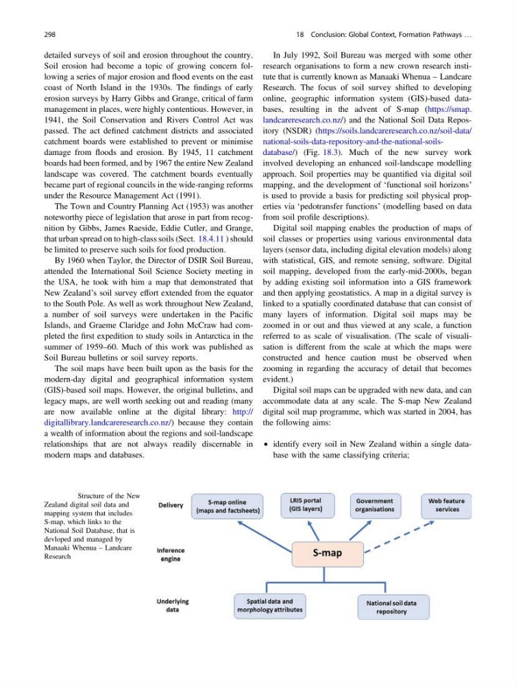
online, geographic information system (GIS)-based databases, resulting in the advent of S-map (https://smap.
landcareresearch.co.nz/) and the National Soil Data Repository (NSDR) (https://soils.landcareresearch.co.nz/soil-data/
national-soils-data-repository-and-the-national-soilsdatabase/) (Fig. 18.3). Much of the new survey work
involved developing an enhanced soil-landscape modelling
approach. Soil properties may be quantified via digital soil
mapping, and the development of ‘functional soil horizons’
is used to provide a basis for predicting soil physical properties via ‘pedotransfer functions’ (modelling based on data
from soil profile descriptions).
Digital soil mapping enables the production of maps of
soil classes or properties using various environmental data
layers (sensor data, including digital elevation models) along
with statistical, GIS, and remote sensing, software. Digital
soil mapping, developed from the early-mid-2000s, began
by adding existing soil information into a GIS framework
and then applying geostatistics. A map in a digital survey is
linked to a spatially coordinated database that can consist of
many layers of information. Digital soil maps may be
zoomed in or out and thus viewed at any scale, a function
referred to as scale of visualisation. (The scale of visualisation is different from the scale at which the maps were
constructed and hence caution must be observed when
zooming in regarding the accuracy of detail that becomes
evident.)
Digital soil maps can be upgraded with new data, and can
accommodate data at any scale. The S-map New Zealand
digital soil map programme, which was started in 2004, has
the following aims:
• identify every soil in New Zealand within a single database with the same classifying criteria;
Fig. 18.3 Structure of the New
Zealand digital soil data and
mapping system that includes
S-map, which links to the
National Soil Database, that is
devloped and managed by
Manaaki Whenua – Landcare
Research
298
18 Conclusion: Global Context, Formation Pathways …
Soil erosion had become a topic of growing concern following a series of major erosion and flood events on the east
coast of North Island in the 1930s. The findings of early
erosion surveys by Harry Gibbs and Grange, critical of farm
management in places, were highly contentious. However, in
1941, the Soil Conservation and Rivers Control Act was
passed. The act defined catchment districts and associated
catchment boards were established to prevent or minimise
damage from floods and erosion. By 1945, 11 catchment
boards had been formed, and by 1967 the entire New Zealand
landscape was covered. The catchment boards eventually
became part of regional councils in the wide-ranging reforms
under the Resource Management Act (1991).
The Town and Country Planning Act (1953) was another
noteworthy piece of legislation that arose in part from recognition by Gibbs, James Raeside, Eddie Cutler, and Grange,
that urban spread on to high-class soils (Sect. 18.4.11 ) should
be limited to preserve such soils for food production.
By 1960 when Taylor, the Director of DSIR Soil Bureau,
attended the International Soil Science Society meeting in
the USA, he took with him a map that demonstrated that
New Zealand’s soil survey effort extended from the equator
to the South Pole. As well as work throughout New Zealand,
a number of soil surveys were undertaken in the Pacific
Islands, and Graeme Claridge and John McCraw had completed the first expedition to study soils in Antarctica in the
summer of 1959–60. Much of this work was published as
Soil Bureau bulletins or soil survey reports.
The soil maps have been built upon as the basis for the
modern-day digital and geographical information system
(GIS)-based soil maps. However, the original bulletins, and
legacy maps, are well worth seeking out and reading (many
are now available online at the digital library: http://
digitallibrary.landcareresearch.co.nz/) because they contain
a wealth of information about the regions and soil-landscape
relationships that are not always readily discernable in
modern maps and databases.
In July 1992, Soil Bureau was merged with some other
research organisations to form a new crown research institute that is currently known as Manaaki Whenua – Landcare
Research. The focus of soil survey shifted to developing
online, geographic information system (GIS)-based databases, resulting in the advent of S-map (https://smap.
landcareresearch.co.nz/) and the National Soil Data Repository (NSDR) (https://soils.landcareresearch.co.nz/soil-data/
national-soils-data-repository-and-the-national-soilsdatabase/) (Fig. 18.3). Much of the new survey work
involved developing an enhanced soil-landscape modelling
approach. Soil properties may be quantified via digital soil
mapping, and the development of ‘functional soil horizons’
is used to provide a basis for predicting soil physical properties via ‘pedotransfer functions’ (modelling based on data
from soil profile descriptions).
Digital soil mapping enables the production of maps of
soil classes or properties using various environmental data
layers (sensor data, including digital elevation models) along
with statistical, GIS, and remote sensing, software. Digital
soil mapping, developed from the early-mid-2000s, began
by adding existing soil information into a GIS framework
and then applying geostatistics. A map in a digital survey is
linked to a spatially coordinated database that can consist of
many layers of information. Digital soil maps may be
zoomed in or out and thus viewed at any scale, a function
referred to as scale of visualisation. (The scale of visualisation is different from the scale at which the maps were
constructed and hence caution must be observed when
zooming in regarding the accuracy of detail that becomes
evident.)
Digital soil maps can be upgraded with new data, and can
accommodate data at any scale. The S-map New Zealand
digital soil map programme, which was started in 2004, has
the following aims:
• identify every soil in New Zealand within a single database with the same classifying criteria;
Fig. 18.3 Structure of the New
Zealand digital soil data and
mapping system that includes
S-map, which links to the
National Soil Database, that is
devloped and managed by
Manaaki Whenua – Landcare
Research
298
18 Conclusion: Global Context, Formation Pathways …