

15.3 Soil-Landscape Relationships
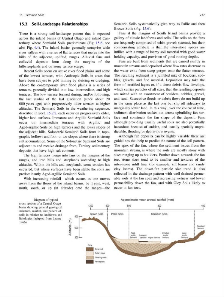
There is a strong soil-landscape pattern that is repeated
across the inland basins of Central Otago and inland Canterbury where Semiarid Soils predominate (Fig. 15.6, see
also Fig. 4.4). The inland basins generally comprise wide
river valleys with a series of flat terraces that merge into the
hills of the adjacent, uplifted, ranges. Alluvial fans and
colluvial deposits form along the margins of the
hill/steeplands and on some terrace scarps.
Recent Soils occur on active river flood plains and some
of the lowest terraces, with Anthropic Soils in areas that
have been subject to gold mining by sluicing or dredging.
Above the contemporary river flood plains is a series of
terraces, generally divided into low, intermediate, and high
terraces. The low terrace formed during, and/or following,
the last stadial of the last glaciation (since about 20
000 years ago) with progressively older terraces at higher
altitudes. The Semiarid Soils in the weathering sequence,
described in Sect. 15.2.2, each occur on progressively older,
higher land surfaces. Immature and Argillic Semiarid Soils
occur on intermediate terraces with Argillic and
Aged-argillic Soils on high terraces and the lower slopes of
the adjacent hills. Solonetzic Semiarid Soils form in topographic hollows and foot- or toe-slopes where there is strong
salt accumulation. Some of the Solonetzic Semiarid Soils are
adjacent to and receive drainage from, Tertiary sedimentary
deposits that have high salt contents.
The high terraces merge into fans on the margins of the
ranges, and into hills and steeplands ascending to high
altitudes. Within the hills and steeplands, some erosion has
occurred, but where surfaces have been stable the soils are
predominantly Aged-argillic Semiarid Soils.
With increasing rainfall—which occurs as one moves
away from the floors of the inland basins, be it east, west,
north, south, or up (in altitude) onto the ranges—the
Semiarid Soils systematically give way to Pallic and then
Brown Soils (Fig. 15.6).
Fans at the margins of South Island basins provide a
gallery of classic landforms and soils. The soils on the fans
are frequently comprised of schist gravels (stones), but their
compensating attribute is that the inter-stone spaces are
infilled with a range of loamy soil material with good water
holding capacity, and provision of good rooting depths.
Fans are built from sediments that are carried swiftly in
mountain streams and deposited where flow rates decrease as
the water exits from steep gorges onto the flatter terraces.
The resulting sediment is a jumbled mix of boulders, cobbles, gravels, and fine material. Deposition may take the
form of stratified layers or, if a dense debris-flow develops,
which carries particles of all sizes, then the resulting deposits
are mixed with an assortment of boulders, cobbles, gravel,
and sand. Successive floods or debris flows do not build up
in the same place as the last one but slip off sideways to
marginally lower land. In this way, over the course of time,
sediment distribution snakes out across upbuilding fan surface and constructs the fan shape of the deposit. Fans
although providing usually useful soils are also potentially
hazardous because of sudden, and usually spatially unpredictable, flooding or debris-flow events.
Although fan deposits can be highly variable there are
guidelines that help to predict the nature of the soil pattern.
The apex of the fan, where the sediment issues from the
mountain stream, is where the soils are mostly stony with
sizes ranging up to boulders. Further down, towards the fan
toe, stone sizes tend to be smaller and textures of the
inter-stone infill finer (for example, silt loams and sandy
clay loams). The down-fan particle size trend is also
reflected in the drainage pattern with well drained permeable soils at the fan apex and increasing wetness and lower
permeability down the fan, and with Gley Soils likely to
occur at fan toes.
Fig. 15.6 Diagram of typical
cross section of a Central Otago
basin showing general geological
structure, rainfall, and pattern of
soils in relation to landforms and
lithologies (adapted from Leamy
1966)
15 Semiarid Soils
237
There is a strong soil-landscape pattern that is repeated
across the inland basins of Central Otago and inland Canterbury where Semiarid Soils predominate (Fig. 15.6, see
also Fig. 4.4). The inland basins generally comprise wide
river valleys with a series of flat terraces that merge into the
hills of the adjacent, uplifted, ranges. Alluvial fans and
colluvial deposits form along the margins of the
hill/steeplands and on some terrace scarps.
Recent Soils occur on active river flood plains and some
of the lowest terraces, with Anthropic Soils in areas that
have been subject to gold mining by sluicing or dredging.
Above the contemporary river flood plains is a series of
terraces, generally divided into low, intermediate, and high
terraces. The low terrace formed during, and/or following,
the last stadial of the last glaciation (since about 20
000 years ago) with progressively older terraces at higher
altitudes. The Semiarid Soils in the weathering sequence,
described in Sect. 15.2.2, each occur on progressively older,
higher land surfaces. Immature and Argillic Semiarid Soils
occur on intermediate terraces with Argillic and
Aged-argillic Soils on high terraces and the lower slopes of
the adjacent hills. Solonetzic Semiarid Soils form in topographic hollows and foot- or toe-slopes where there is strong
salt accumulation. Some of the Solonetzic Semiarid Soils are
adjacent to and receive drainage from, Tertiary sedimentary
deposits that have high salt contents.
The high terraces merge into fans on the margins of the
ranges, and into hills and steeplands ascending to high
altitudes. Within the hills and steeplands, some erosion has
occurred, but where surfaces have been stable the soils are
predominantly Aged-argillic Semiarid Soils.
With increasing rainfall—which occurs as one moves
away from the floors of the inland basins, be it east, west,
north, south, or up (in altitude) onto the ranges—the
Semiarid Soils systematically give way to Pallic and then
Brown Soils (Fig. 15.6).
Fans at the margins of South Island basins provide a
gallery of classic landforms and soils. The soils on the fans
are frequently comprised of schist gravels (stones), but their
compensating attribute is that the inter-stone spaces are
infilled with a range of loamy soil material with good water
holding capacity, and provision of good rooting depths.
Fans are built from sediments that are carried swiftly in
mountain streams and deposited where flow rates decrease as
the water exits from steep gorges onto the flatter terraces.
The resulting sediment is a jumbled mix of boulders, cobbles, gravels, and fine material. Deposition may take the
form of stratified layers or, if a dense debris-flow develops,
which carries particles of all sizes, then the resulting deposits
are mixed with an assortment of boulders, cobbles, gravel,
and sand. Successive floods or debris flows do not build up
in the same place as the last one but slip off sideways to
marginally lower land. In this way, over the course of time,
sediment distribution snakes out across upbuilding fan surface and constructs the fan shape of the deposit. Fans
although providing usually useful soils are also potentially
hazardous because of sudden, and usually spatially unpredictable, flooding or debris-flow events.
Although fan deposits can be highly variable there are
guidelines that help to predict the nature of the soil pattern.
The apex of the fan, where the sediment issues from the
mountain stream, is where the soils are mostly stony with
sizes ranging up to boulders. Further down, towards the fan
toe, stone sizes tend to be smaller and textures of the
inter-stone infill finer (for example, silt loams and sandy
clay loams). The down-fan particle size trend is also
reflected in the drainage pattern with well drained permeable soils at the fan apex and increasing wetness and lower
permeability down the fan, and with Gley Soils likely to
occur at fan toes.
Fig. 15.6 Diagram of typical
cross section of a Central Otago
basin showing general geological
structure, rainfall, and pattern of
soils in relation to landforms and
lithologies (adapted from Leamy
1966)
15 Semiarid Soils
237