

sands or loamy sands. However, in the Weathered
Aged-Argillic Semiarid Soil the gravel interstices are infilled
with sandy clay. The clay-bound gravels are common on the
older, higher, land surfaces and it is understood that the clay
has been moved in suspension and ‘filtered’ amidst the
gravels over the long period since the gravel deposition.
Leamy suggested that the oldest soils with very thick, red
clay pans represented the accumulation of clay for at least
four glacial-interglacial cycles inferred to date back to a
period described geologically as the Porikan stage, which is
now dated at c. 350,000 years ago. One hypothesis regarding the red colouration of the argillic horizons is that the red
colour is derived from additions of red-weathered clay-sized
dust particles blown across the Tasman Sea from Australia.
Such material (much finer than local, New Zealand-derived
loess) is common in southern and eastern Australia and
termed ‘parna’. The wide distribution of red dust is documented in southern Europe, the Middle East, and oceanic
islands with sources mainly in North Africa. Red dust has
been observed falling in New Zealand following Australian
dust storms, thus the hypothesis is plausible. In addition to
the historical evidence of Australian-derived dust fall, analyses by Sam Marx and others of pre-historic dust accumulation in a peat bog on Old Man Range showed that the
average deposition rate of Australian dust since c.
8000 years ago was 0.6 g m
−2 yr
−1 , with deposition rates as
high as 1.4 g m
−2 yr
−1 during the mid-Holocene, implying
that Australian dust has contributed >5 kg m
−2 of dust to
Otago (and other parts of New Zealand) during the Holocene
period (since c. 11,700 years ago). Greater amounts would
have accumulated during glacial periods as shown from
studies of sediment in cores from the Tasman Sea.
An alternative hypothesis is that the red-weathered material is
derived from clay that was originally red-weathered during the
Cretaceous and which was then preserved on some old land
surfaces in Otago (Chap. 16), and as far north as Wellington.
15.2.3 Salts, Sodium, and the Origin of Salinity
and Sodicity
Most soils generate salts as a product of chemical weathering. Under higher rainfall the salts are leached from the soil
into the groundwater and eventually pass through the
hydrological network to the ocean. However, in Semiarid
Soils, in most years, there is too little rain to wash the salts
through the soil. Instead, the salts precipitate and accumulate
in the soil. In Central Otago, the salts probably have three
main sources: (1) from the chemical dissolution and
hydrolysis of minerals in rocks and soil; (2) the deposition,
with rainfall, of salts carried with water evaporated from the
ocean (marine aerosol flux); and (3) aeolian dust carried
across the Tasman Sea from Australia. Deposition with rain
occurs in miniscule amounts, and the Australia aeolian dust
influx is also relatively small, but accumulations nevertheless build up over thousands of years, in a dry, stable,
landscape.
In Otago, the most saline (sodium salt-rich) areas occur
where the weathered schist is almost totally transformed to
kaolinite. Such areas act as reservoirs that slowly leak salt,
via water tables, into the adjacent land. The highly weathered schist, and associated weakly saline mudstones (Manuherikia group sediments), are the common basement rocks
beneath the fans and terraces. The area where salt accumulation has been most obvious is in the Maniototo Basin
where saline patches have been observed from the time of
the early settlers and presumably have formed naturally.
The white Ck soil horizons (designated as calcareous
horizons in the New Zealand Soil Classification), which
form in some Semiarid Soils, contain accumulations of salts,
dominated by calcium carbonate (lime). No significant natural geologic limestone rocks occur in the Central Otago
region and isotope analyses by Leamy and Athol Rafter
established that the calcium carbonates were of pedogenic
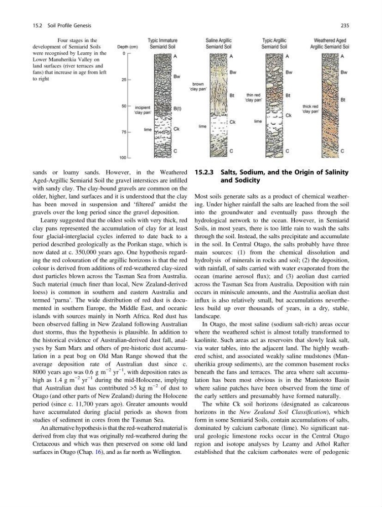
Fig. 15.4 Four stages in the
development of Semiarid Soils
were recognised by Leamy in the
Lower Manuherikia Valley on
land surfaces (river terraces and
fans) that increase in age from left
to right
15.2 Soil Profile Genesis
235
Aged-Argillic Semiarid Soil the gravel interstices are infilled
with sandy clay. The clay-bound gravels are common on the
older, higher, land surfaces and it is understood that the clay
has been moved in suspension and ‘filtered’ amidst the
gravels over the long period since the gravel deposition.
Leamy suggested that the oldest soils with very thick, red
clay pans represented the accumulation of clay for at least
four glacial-interglacial cycles inferred to date back to a
period described geologically as the Porikan stage, which is
now dated at c. 350,000 years ago. One hypothesis regarding the red colouration of the argillic horizons is that the red
colour is derived from additions of red-weathered clay-sized
dust particles blown across the Tasman Sea from Australia.
Such material (much finer than local, New Zealand-derived
loess) is common in southern and eastern Australia and
termed ‘parna’. The wide distribution of red dust is documented in southern Europe, the Middle East, and oceanic
islands with sources mainly in North Africa. Red dust has
been observed falling in New Zealand following Australian
dust storms, thus the hypothesis is plausible. In addition to
the historical evidence of Australian-derived dust fall, analyses by Sam Marx and others of pre-historic dust accumulation in a peat bog on Old Man Range showed that the
average deposition rate of Australian dust since c.
8000 years ago was 0.6 g m
−2 yr
−1 , with deposition rates as
high as 1.4 g m
−2 yr
−1 during the mid-Holocene, implying
that Australian dust has contributed >5 kg m
−2 of dust to
Otago (and other parts of New Zealand) during the Holocene
period (since c. 11,700 years ago). Greater amounts would
have accumulated during glacial periods as shown from
studies of sediment in cores from the Tasman Sea.
An alternative hypothesis is that the red-weathered material is
derived from clay that was originally red-weathered during the
Cretaceous and which was then preserved on some old land
surfaces in Otago (Chap. 16), and as far north as Wellington.
15.2.3 Salts, Sodium, and the Origin of Salinity
and Sodicity
Most soils generate salts as a product of chemical weathering. Under higher rainfall the salts are leached from the soil
into the groundwater and eventually pass through the
hydrological network to the ocean. However, in Semiarid
Soils, in most years, there is too little rain to wash the salts
through the soil. Instead, the salts precipitate and accumulate
in the soil. In Central Otago, the salts probably have three
main sources: (1) from the chemical dissolution and
hydrolysis of minerals in rocks and soil; (2) the deposition,
with rainfall, of salts carried with water evaporated from the
ocean (marine aerosol flux); and (3) aeolian dust carried
across the Tasman Sea from Australia. Deposition with rain
occurs in miniscule amounts, and the Australia aeolian dust
influx is also relatively small, but accumulations nevertheless build up over thousands of years, in a dry, stable,
landscape.
In Otago, the most saline (sodium salt-rich) areas occur
where the weathered schist is almost totally transformed to
kaolinite. Such areas act as reservoirs that slowly leak salt,
via water tables, into the adjacent land. The highly weathered schist, and associated weakly saline mudstones (Manuherikia group sediments), are the common basement rocks
beneath the fans and terraces. The area where salt accumulation has been most obvious is in the Maniototo Basin
where saline patches have been observed from the time of
the early settlers and presumably have formed naturally.
The white Ck soil horizons (designated as calcareous
horizons in the New Zealand Soil Classification), which
form in some Semiarid Soils, contain accumulations of salts,
dominated by calcium carbonate (lime). No significant natural geologic limestone rocks occur in the Central Otago
region and isotope analyses by Leamy and Athol Rafter
established that the calcium carbonates were of pedogenic
Fig. 15.4 Four stages in the
development of Semiarid Soils
were recognised by Leamy in the
Lower Manuherikia Valley on
land surfaces (river terraces and
fans) that increase in age from left
to right
15.2 Soil Profile Genesis
235