

14.3 Soil-Landscape Relationships
14.3.1 High Soil Variability in Alluvial Flood
Plain Soils
Soils on flood plains are commonly highly variable, with soil
properties changing at the scale of a paddock, or even over a
few metres (Fig. 14.5). Depending partly on catchment
lithologies, coarse sediments ranging from boulders, cobbles, gravels, and sands tend to be deposited within the river
bed, according to the turbulence and flow in the river, and
finer sand, silt, and clay materials in overbank flood deposits.
As a river gradually migrates back and forth over a landscape, different layers build up over one another. In back
swamp areas, peat deposits may form, only to be later buried
by gravelly sands or finer sediments deposited by a later shift
in the main river bed. The complexity that can result from
such processes is evident in a braided river bed (Fig. 14.1).
The pattern in soil parent materials, and thus the soils that
form, is often visible from the air, particularly in dry summer
periods (Fig. 14.5) where the stonier (coarser) soils dry out
faster and show up as browner than neighbouring areas of
finer materials that hold moisture for longer.
When less sediment is available, or there has been tectonic
uplift, or a change in climate, the rivers gradually cut down
through the sediments, becoming entrenched. The nature of the
sediment, its texture, mode of deposition, stoniness,
post-deposition erosion, wetness gradients, and management
effects, all contribute to complex patterns of soil variability. It is
desirable to map soil variability within areas that can be practically managed so that land management can be matched to
soil properties. However, the soil variability is often so complex that a very large-scale map is needed. Precision agriculture
is developing to address such issues of spatial variability.
The base level, the lowest level to which a stream can
erode, influences the landforms and sedimentation patterns
that control the development of Fluvial Recent Soils. The base
level is set ultimately by sea level, with lakes, and bedrock
highs, providing sub-base levels within a catchment. Where
land is above the base level, a river will have a reasonable
slope, and so flows swiftly and has potential energy to cut into
its bed, erode sediment, and entrench its self into the landscape. Where a river is close to base level, slopes are low and
in such a near-flat situation a river has no power to erode its
bed but is able to transport and deposit sediments carried from
upstream erosion. Many of the highly productive alluvial
basins of New Zealand, such as the lower Manawatu, are
formed by material deposited near a base level. The Rangitaiki
Plains in eastern Bay of Plenty are subsiding tectonically and
the land is remaining above sea level (maintaining freeboard)
mainly because of recurring volcanic events and flooding that
have deposited new material during the Holocene. Tectonism,
volcanic eruptions, storminess, an easily eroded catchment
rock (mudstone), and several large meandering rivers have
similarly combined to control the development of the Gisborne Plain (Poverty Bay Flats) and its detailed fluvial history
and predominant, fertile, Fluvial Recent Soils.
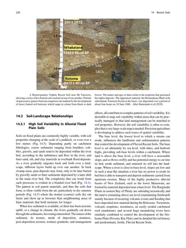
Fig. 14.4 A Buried-pumice Tephric Recent Soil near Mt Tarawera,
showing a series of five buried soils stacked on top of one another. Periods
of quiescence (pauses between eruptions) are marked by the development
of (now) buried soil horizons which range in colour from black to dark
brown. The names and ages or dates relate to the eruptions that generated
the tephra deposits. The uppermost material, the Rotomahana Mud (with
subordinate Tarawera Scoria at the base), was deposited over a period of
about four hours on 10 June 1886. After Hartemink et al (2020)
220
14 Recent Soils
14.3.1 High Soil Variability in Alluvial Flood
Plain Soils
Soils on flood plains are commonly highly variable, with soil
properties changing at the scale of a paddock, or even over a
few metres (Fig. 14.5). Depending partly on catchment
lithologies, coarse sediments ranging from boulders, cobbles, gravels, and sands tend to be deposited within the river
bed, according to the turbulence and flow in the river, and
finer sand, silt, and clay materials in overbank flood deposits.
As a river gradually migrates back and forth over a landscape, different layers build up over one another. In back
swamp areas, peat deposits may form, only to be later buried
by gravelly sands or finer sediments deposited by a later shift
in the main river bed. The complexity that can result from
such processes is evident in a braided river bed (Fig. 14.1).
The pattern in soil parent materials, and thus the soils that
form, is often visible from the air, particularly in dry summer
periods (Fig. 14.5) where the stonier (coarser) soils dry out
faster and show up as browner than neighbouring areas of
finer materials that hold moisture for longer.
When less sediment is available, or there has been tectonic
uplift, or a change in climate, the rivers gradually cut down
through the sediments, becoming entrenched. The nature of the
sediment, its texture, mode of deposition, stoniness,
post-deposition erosion, wetness gradients, and management
effects, all contribute to complex patterns of soil variability. It is
desirable to map soil variability within areas that can be practically managed so that land management can be matched to
soil properties. However, the soil variability is often so complex that a very large-scale map is needed. Precision agriculture
is developing to address such issues of spatial variability.
The base level, the lowest level to which a stream can
erode, influences the landforms and sedimentation patterns
that control the development of Fluvial Recent Soils. The base
level is set ultimately by sea level, with lakes, and bedrock
highs, providing sub-base levels within a catchment. Where
land is above the base level, a river will have a reasonable
slope, and so flows swiftly and has potential energy to cut into
its bed, erode sediment, and entrench its self into the landscape. Where a river is close to base level, slopes are low and
in such a near-flat situation a river has no power to erode its
bed but is able to transport and deposit sediments carried from
upstream erosion. Many of the highly productive alluvial
basins of New Zealand, such as the lower Manawatu, are
formed by material deposited near a base level. The Rangitaiki
Plains in eastern Bay of Plenty are subsiding tectonically and
the land is remaining above sea level (maintaining freeboard)
mainly because of recurring volcanic events and flooding that
have deposited new material during the Holocene. Tectonism,
volcanic eruptions, storminess, an easily eroded catchment
rock (mudstone), and several large meandering rivers have
similarly combined to control the development of the Gisborne Plain (Poverty Bay Flats) and its detailed fluvial history
and predominant, fertile, Fluvial Recent Soils.
Fig. 14.4 A Buried-pumice Tephric Recent Soil near Mt Tarawera,
showing a series of five buried soils stacked on top of one another. Periods
of quiescence (pauses between eruptions) are marked by the development
of (now) buried soil horizons which range in colour from black to dark
brown. The names and ages or dates relate to the eruptions that generated
the tephra deposits. The uppermost material, the Rotomahana Mud (with
subordinate Tarawera Scoria at the base), was deposited over a period of
about four hours on 10 June 1886. After Hartemink et al (2020)
220
14 Recent Soils