

Pumice Soils are sandy to gravelly and dominated by
weakly weathered pumice, and glassy siliceous sand and silt
(also referred to as ash, which comprises particles <2 mm in
diameter). Pumice clasts >64 mm in diameter (described as
blocks or bombs volcanologically or as very coarse gravels
to boulders pedologically) can be common depending on the
depositional setting and location.
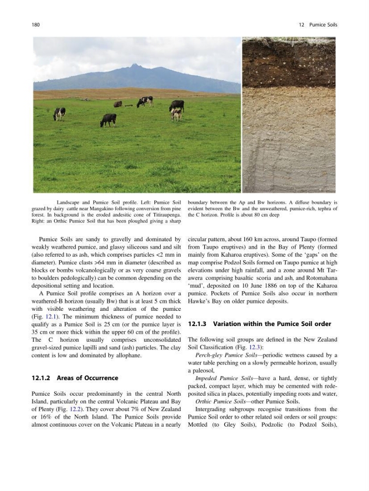
A Pumice Soil profile comprises an A horizon over a
weathered-B horizon (usually Bw) that is at least 5 cm thick
with visible weathering and alteration of the pumice
(Fig. 12.1). The minimum thickness of pumice needed to
qualify as a Pumice Soil is 25 cm (or the pumice layer is
35 cm or more thick within the upper 60 cm of the profile).
The C horizon usually comprises unconsolidated
gravel-sized pumice lapilli and sand (ash) particles. The clay
content is low and dominated by allophane.
12.1.2 Areas of Occurrence
Pumice Soils occur predominantly in the central North
Island, particularly on the central Volcanic Plateau and Bay
of Plenty (Fig. 12.2). They cover about 7% of New Zealand
or 16% of the North Island. The Pumice Soils provide
almost continuous cover on the Volcanic Plateau in a nearly
circular pattern, about 160 km across, around Taupo (formed
from Taupo eruptives) and in the Bay of Plenty (formed
mainly from Kaharoa eruptives). Some of the ‘gaps’ on the
map comprise Podzol Soils formed on Taupo pumice at high
elevations under high rainfall, and a zone around Mt Tarawera comprising basaltic scoria and ash, and Rotomahana
‘mud’, deposited on 10 June 1886 on top of the Kaharoa
pumice. Pockets of Pumice Soils also occur in northern
Hawke’s Bay on older pumice deposits.
12.1.3 Variation within the Pumice Soil order
The following soil groups are defined in the New Zealand
Soil Classification (Fig. 12.3):
Perch-gley Pumice Soils—periodic wetness caused by a
water table perching on a slowly permeable horizon, usually
a paleosol,
Impeded Pumice Soils—have a hard, dense, or tightly
packed, compact layer, which may be cemented with redeposited silica in places, potentially impeding roots and water,
Orthic Pumice Soils—other Pumice Soils.
Intergrading subgroups recognise transitions from the
Pumice Soil order to other related soil orders or soil groups:
Mottled (to Gley Soils), Podzolic (to Podzol Soils),
Fig. 12.1 Landscape and Pumice Soil profile. Left: Pumice Soil
grazed by dairy cattle near Mangakino following conversion from pine
forest. In background is the eroded andesitic cone of Titiraupenga.
Right: an Orthic Pumice Soil that has been ploughed giving a sharp
boundary between the Ap and Bw horizons. A diffuse boundary is
evident between the Bw and the unweathered, pumice-rich, tephra of
the C horizon. Profile is about 80 cm deep
180
12 Pumice Soils
weakly weathered pumice, and glassy siliceous sand and silt
(also referred to as ash, which comprises particles <2 mm in
diameter). Pumice clasts >64 mm in diameter (described as
blocks or bombs volcanologically or as very coarse gravels
to boulders pedologically) can be common depending on the
depositional setting and location.
A Pumice Soil profile comprises an A horizon over a
weathered-B horizon (usually Bw) that is at least 5 cm thick
with visible weathering and alteration of the pumice
(Fig. 12.1). The minimum thickness of pumice needed to
qualify as a Pumice Soil is 25 cm (or the pumice layer is
35 cm or more thick within the upper 60 cm of the profile).
The C horizon usually comprises unconsolidated
gravel-sized pumice lapilli and sand (ash) particles. The clay
content is low and dominated by allophane.
12.1.2 Areas of Occurrence
Pumice Soils occur predominantly in the central North
Island, particularly on the central Volcanic Plateau and Bay
of Plenty (Fig. 12.2). They cover about 7% of New Zealand
or 16% of the North Island. The Pumice Soils provide
almost continuous cover on the Volcanic Plateau in a nearly
circular pattern, about 160 km across, around Taupo (formed
from Taupo eruptives) and in the Bay of Plenty (formed
mainly from Kaharoa eruptives). Some of the ‘gaps’ on the
map comprise Podzol Soils formed on Taupo pumice at high
elevations under high rainfall, and a zone around Mt Tarawera comprising basaltic scoria and ash, and Rotomahana
‘mud’, deposited on 10 June 1886 on top of the Kaharoa
pumice. Pockets of Pumice Soils also occur in northern
Hawke’s Bay on older pumice deposits.
12.1.3 Variation within the Pumice Soil order
The following soil groups are defined in the New Zealand
Soil Classification (Fig. 12.3):
Perch-gley Pumice Soils—periodic wetness caused by a
water table perching on a slowly permeable horizon, usually
a paleosol,
Impeded Pumice Soils—have a hard, dense, or tightly
packed, compact layer, which may be cemented with redeposited silica in places, potentially impeding roots and water,
Orthic Pumice Soils—other Pumice Soils.
Intergrading subgroups recognise transitions from the
Pumice Soil order to other related soil orders or soil groups:
Mottled (to Gley Soils), Podzolic (to Podzol Soils),
Fig. 12.1 Landscape and Pumice Soil profile. Left: Pumice Soil
grazed by dairy cattle near Mangakino following conversion from pine
forest. In background is the eroded andesitic cone of Titiraupenga.
Right: an Orthic Pumice Soil that has been ploughed giving a sharp
boundary between the Ap and Bw horizons. A diffuse boundary is
evident between the Bw and the unweathered, pumice-rich, tephra of
the C horizon. Profile is about 80 cm deep
180
12 Pumice Soils