

and deposited onto the surrounding terraces and adjacent
landforms, being driven by the belt of strong westerly winds
that blew during the glacials. When the climate warmed, the
vegetation cover improved, erosion declined, and the rivers,
with reduced bedload, then started cutting down through,
and removing, the previously deposited sediment. Thus a
terrace was left behind and a new flood plain formed at a
lower level. The gradual tectonic uplift of the land also
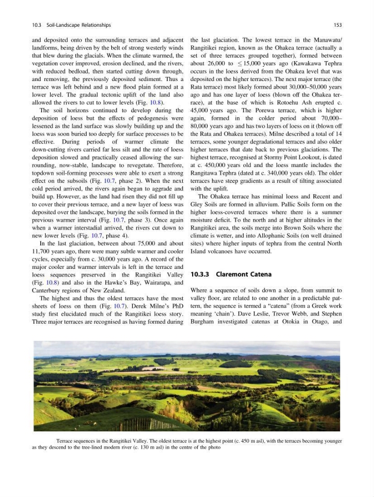
allowed the rivers to cut to lower levels (Fig. 10.8).
The soil horizons continued to develop during the
deposition of loess but the effects of pedogenesis were
lessened as the land surface was slowly building up and the
loess was soon buried too deeply for surface processes to be
effective. During periods of warmer climate the
down-cutting rivers carried far less silt and the rate of loess
deposition slowed and practically ceased allowing the surrounding, now-stable, landscape to revegetate. Therefore,
topdown soil-forming processes were able to exert a strong
effect on the subsoils (Fig. 10.7, phase 2). When the next
cold period arrived, the rivers again began to aggrade and
build up. However, as the land had risen they did not fill up
to cover their previous terrace, and a new layer of loess was
deposited over the landscape, burying the soils formed in the
previous warmer interval (Fig. 10.7, phase 3). Once again
when a warmer interstadial arrived, the rivers cut down to
new lower levels (Fig. 10.7, phase 4).
In the last glaciation, between about 75,000 and about
11,700 years ago, there were many subtle warmer and cooler
cycles, especially from c. 30,000 years ago. A record of the
major cooler and warmer intervals is left in the terrace and
loess sequences preserved in the Rangitikei Valley
(Fig. 10.8) and also in the Hawke’s Bay, Wairarapa, and
Canterbury regions of New Zealand.
The highest and thus the oldest terraces have the most
sheets of loess on them (Fig. 10.7). Derek Milne’s PhD
study first elucidated much of the Rangitikei loess story.
Three major terraces are recognised as having formed during
the last glaciation. The lowest terrace in the Manawatu/
Rangitikei region, known as the Ohakea terrace (actually a
set of three terraces grouped together), formed between
about 26,000 to 15,000 years ago (Kawakawa Tephra
occurs in the loess derived from the Ohakea level that was
deposited on the higher terraces). The next major terrace (the
Rata terrace) most likely formed about 30,000–50,000 years
ago and has one layer of loess (blown off the Ohakea terrace), at the base of which is Rotoehu Ash erupted c.
45,000 years ago. The Porewa terrace, which is higher
again, formed in the colder period about 70,000–
80,000 years ago and has two layers of loess on it (blown off
the Rata and Ohakea terraces). Milne described a total of 14
terraces, some younger degradational terraces and also older
higher terraces that date back to previous glaciations. The
highest terrace, recognised at Stormy Point Lookout, is dated
at c. 450,000 years old and the loess mantle includes the
Rangitawa Tephra (dated at c. 340,000 years old). The older
terraces have steep gradients as a result of tilting associated
with the uplift.
The Ohakea terrace has minimal loess and Recent and
Gley Soils are formed in alluvium. Pallic Soils form on the
higher loess-covered terraces where there is a summer
moisture deficit. To the north and at higher altitudes in the
Rangitikei area, the soils merge into Brown Soils where the
climate is wetter, and into Allophanic Soils (on well drained
sites) where higher inputs of tephra from the central North
Island volcanoes have occurred.
10.3.3 Claremont Catena
Where a sequence of soils down a slope, from summit to
valley floor, are related to one another in a predictable pattern, the sequence is termed a “catena” (from a Greek work
meaning ‘chain’). Dave Leslie, Trevor Webb, and Stephen
Burgham investigated catenas at Otokia in Otago, and
Fig. 10.8 Terrace sequences in the Rangitikei Valley. The oldest terrace is at the highest point (c. 450 m asl), with the terraces becoming younger
as they descend to the tree-lined modern river (c. 130 m asl) in the centre of the photo
10.3 Soil-Landscape Relationships
153
landforms, being driven by the belt of strong westerly winds
that blew during the glacials. When the climate warmed, the
vegetation cover improved, erosion declined, and the rivers,
with reduced bedload, then started cutting down through,
and removing, the previously deposited sediment. Thus a
terrace was left behind and a new flood plain formed at a
lower level. The gradual tectonic uplift of the land also
allowed the rivers to cut to lower levels (Fig. 10.8).
The soil horizons continued to develop during the
deposition of loess but the effects of pedogenesis were
lessened as the land surface was slowly building up and the
loess was soon buried too deeply for surface processes to be
effective. During periods of warmer climate the
down-cutting rivers carried far less silt and the rate of loess
deposition slowed and practically ceased allowing the surrounding, now-stable, landscape to revegetate. Therefore,
topdown soil-forming processes were able to exert a strong
effect on the subsoils (Fig. 10.7, phase 2). When the next
cold period arrived, the rivers again began to aggrade and
build up. However, as the land had risen they did not fill up
to cover their previous terrace, and a new layer of loess was
deposited over the landscape, burying the soils formed in the
previous warmer interval (Fig. 10.7, phase 3). Once again
when a warmer interstadial arrived, the rivers cut down to
new lower levels (Fig. 10.7, phase 4).
In the last glaciation, between about 75,000 and about
11,700 years ago, there were many subtle warmer and cooler
cycles, especially from c. 30,000 years ago. A record of the
major cooler and warmer intervals is left in the terrace and
loess sequences preserved in the Rangitikei Valley
(Fig. 10.8) and also in the Hawke’s Bay, Wairarapa, and
Canterbury regions of New Zealand.
The highest and thus the oldest terraces have the most
sheets of loess on them (Fig. 10.7). Derek Milne’s PhD
study first elucidated much of the Rangitikei loess story.
Three major terraces are recognised as having formed during
the last glaciation. The lowest terrace in the Manawatu/
Rangitikei region, known as the Ohakea terrace (actually a
set of three terraces grouped together), formed between
about 26,000 to 15,000 years ago (Kawakawa Tephra
occurs in the loess derived from the Ohakea level that was
deposited on the higher terraces). The next major terrace (the
Rata terrace) most likely formed about 30,000–50,000 years
ago and has one layer of loess (blown off the Ohakea terrace), at the base of which is Rotoehu Ash erupted c.
45,000 years ago. The Porewa terrace, which is higher
again, formed in the colder period about 70,000–
80,000 years ago and has two layers of loess on it (blown off
the Rata and Ohakea terraces). Milne described a total of 14
terraces, some younger degradational terraces and also older
higher terraces that date back to previous glaciations. The
highest terrace, recognised at Stormy Point Lookout, is dated
at c. 450,000 years old and the loess mantle includes the
Rangitawa Tephra (dated at c. 340,000 years old). The older
terraces have steep gradients as a result of tilting associated
with the uplift.
The Ohakea terrace has minimal loess and Recent and
Gley Soils are formed in alluvium. Pallic Soils form on the
higher loess-covered terraces where there is a summer
moisture deficit. To the north and at higher altitudes in the
Rangitikei area, the soils merge into Brown Soils where the
climate is wetter, and into Allophanic Soils (on well drained
sites) where higher inputs of tephra from the central North
Island volcanoes have occurred.
10.3.3 Claremont Catena
Where a sequence of soils down a slope, from summit to
valley floor, are related to one another in a predictable pattern, the sequence is termed a “catena” (from a Greek work
meaning ‘chain’). Dave Leslie, Trevor Webb, and Stephen
Burgham investigated catenas at Otokia in Otago, and
Fig. 10.8 Terrace sequences in the Rangitikei Valley. The oldest terrace is at the highest point (c. 450 m asl), with the terraces becoming younger
as they descend to the tree-lined modern river (c. 130 m asl) in the centre of the photo
10.3 Soil-Landscape Relationships
153