

410 Seismograms as Signals
6.6.9 Regional networks
Regional networks, intermediate between global networks and
arrays, are usually constructed to monitor local seismicity or
volcanism. Including Alaska, Hawaii, and Puerto Rico, over
3200 seismic stations are part of more than 40 separate US
networks (Fig. 6.6-18). Some have only a few stations, and
some have hundreds. Many use short-period vertical sensors,
but some use accelerometers. For example, the California
Strong-Motion Instrumentation Program operates more than
400 accelerometers to provide data for earthquake engineers.
Strong-motion data also provide excellent information on
source properties because much of the seismic signal is severely
attenuated at teleseismic distances. Some networks also incorporate broadband seismometers. For instance, as of 2000, the
Southern California Seismographic Network operated 79 broadband stations in addition to its 163 short-period instruments.
Regional network stations can also be valuable for earth structure studies, as shown in Fig. 6.6-19.
Many countries have regional networks. For instance, as
of 1999, Japan had about 560 stations in operation. These
stations have provided valuable data about the subduction
process there, including the double seismic zones (Fig. 5.4-20)
and ScS-to-P conversions at the slab top (Fig. 2.6-15).
Regional networks, like global networks, are continually
being upgraded. In the USA there are efforts under way, as part
of the Advanced National Seismic System (ANSS), to install
more broadband and short-period seismometers, and to add
about 6000 strong-motion sensors in urban areas at risk from
damaging earthquakes. A very ambitious network planned is
the USArray, which would have three different components
operating simultaneously. First, the number of permanent
broadband stations would be increased (Fig. 6.6-20, left).
Second, 400 portable broadband seismometers would travel
around the country. Over eight years, this “bigfoot” array
would visit about 2000 sites in the continental USA, with
an average station spacing of about 70 km, before going to
Alaska and Hawaii (Fig. 6.6-20, right). Third, about 2400
seismometers (a mix of broadband, short-period, and highfrequency sensors) would be used as flexible arrays to accompany the moving array. As planned, USArray will be an array at
the scale of a regional network. Data from the moving array
will be available in near-real time, and can be processed using
migration techniques to attain high-resolution imaging deep
into the mantle.
Interestingly, because there is an increasing trend toward
real-time telemetry for transmitting data from the sensors,
seismology is moving toward a situation where data from
global networks, regional networks, and many local arrays
can be easily combined, largely eliminating the distinctions
between networks. This development offers great scientific
opportunities.
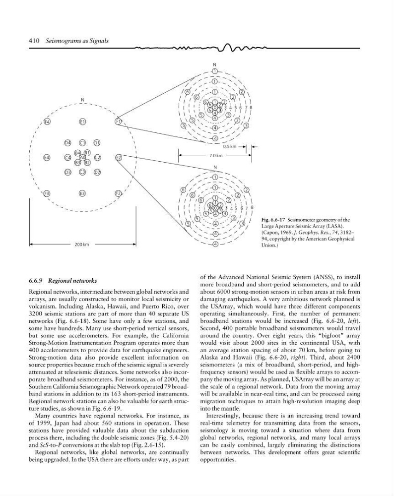
Fig. 6.6-17 Seismometer geometry of the
Large Aperture Seismic Array (LASA).
(Capon, 1969. J. Geophys. Res., 74, 3182–
94, copyright by the American Geophysical
Union.)
2
1
1
1
1
0
4
4
3 3
3
3
2
2
2
3 4
5
5
5
5
6
6
6
6
4
4
200 km
F4
E1
D4
C1
D1
B4
B2
C2
C3
D3
D2
B3
B1
A0
C4
E4
F1
E2
F2
E3
F3
N
7.0 km
0.5 km
N
1
2
2
3
4
5
6 0
N
8
1
3
5
7
3
2
3
4
4
6
3
4
5
5
6
6
6
1
1
3 4 5
2
2
5 6 7 8
6.6.9 Regional networks
Regional networks, intermediate between global networks and
arrays, are usually constructed to monitor local seismicity or
volcanism. Including Alaska, Hawaii, and Puerto Rico, over
3200 seismic stations are part of more than 40 separate US
networks (Fig. 6.6-18). Some have only a few stations, and
some have hundreds. Many use short-period vertical sensors,
but some use accelerometers. For example, the California
Strong-Motion Instrumentation Program operates more than
400 accelerometers to provide data for earthquake engineers.
Strong-motion data also provide excellent information on
source properties because much of the seismic signal is severely
attenuated at teleseismic distances. Some networks also incorporate broadband seismometers. For instance, as of 2000, the
Southern California Seismographic Network operated 79 broadband stations in addition to its 163 short-period instruments.
Regional network stations can also be valuable for earth structure studies, as shown in Fig. 6.6-19.
Many countries have regional networks. For instance, as
of 1999, Japan had about 560 stations in operation. These
stations have provided valuable data about the subduction
process there, including the double seismic zones (Fig. 5.4-20)
and ScS-to-P conversions at the slab top (Fig. 2.6-15).
Regional networks, like global networks, are continually
being upgraded. In the USA there are efforts under way, as part
of the Advanced National Seismic System (ANSS), to install
more broadband and short-period seismometers, and to add
about 6000 strong-motion sensors in urban areas at risk from
damaging earthquakes. A very ambitious network planned is
the USArray, which would have three different components
operating simultaneously. First, the number of permanent
broadband stations would be increased (Fig. 6.6-20, left).
Second, 400 portable broadband seismometers would travel
around the country. Over eight years, this “bigfoot” array
would visit about 2000 sites in the continental USA, with
an average station spacing of about 70 km, before going to
Alaska and Hawaii (Fig. 6.6-20, right). Third, about 2400
seismometers (a mix of broadband, short-period, and highfrequency sensors) would be used as flexible arrays to accompany the moving array. As planned, USArray will be an array at
the scale of a regional network. Data from the moving array
will be available in near-real time, and can be processed using
migration techniques to attain high-resolution imaging deep
into the mantle.
Interestingly, because there is an increasing trend toward
real-time telemetry for transmitting data from the sensors,
seismology is moving toward a situation where data from
global networks, regional networks, and many local arrays
can be easily combined, largely eliminating the distinctions
between networks. This development offers great scientific
opportunities.
Fig. 6.6-17 Seismometer geometry of the
Large Aperture Seismic Array (LASA).
(Capon, 1969. J. Geophys. Res., 74, 3182–
94, copyright by the American Geophysical
Union.)
2
1
1
1
1
0
4
4
3 3
3
3
2
2
2
3 4
5
5
5
5
6
6
6
6
4
4
200 km
F4
E1
D4
C1
D1
B4
B2
C2
C3
D3
D2
B3
B1
A0
C4
E4
F1
E2
F2
E3
F3
N
7.0 km
0.5 km
N
1
2
2
3
4
5
6 0
N
8
1
3
5
7
3
2
3
4
4
6
3
4
5
5
6
6
6
1
1
3 4 5
2
2
5 6 7 8