

46°
(c)
44°
42°
40°
38°
36°
34°
32°
30°
20°
25°
30°
35°
40°
45°
0
200
400
600
km
9 + – 2
24 ± 2
18 ± 2
6 ± 2
?
Eurasian plate
Arabian plate
African plate
30 ± 2
?
10 ± 2
Caucasus convergence
E. Turkey distributed strike-slip
zone
Anotolian plate
W. NAF and NAT strike-slip and
extensional zone
W. Turkey and SE Aegean zone
of N–S extension
SW Aegean/Peloponnesus plate
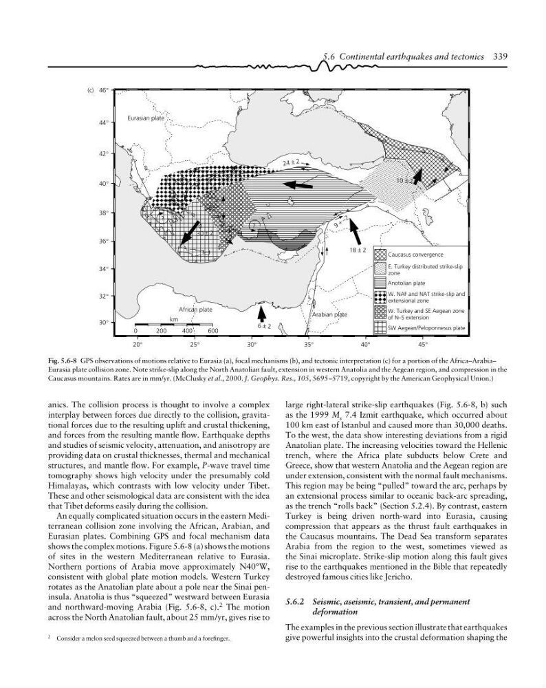
Fig. 5.6-8 GPS observations of motions relative to Eurasia (a), focal mechanisms (b), and tectonic interpretation (c) for a portion of the Africa–Arabia–
Eurasia plate collision zone. Note strike-slip along the North Anatolian fault, extension in western Anatolia and the Aegean region, and compression in the
Caucasus mountains. Rates are in mm/yr. (McClusky et al., 2000. J. Geophys. Res., 105, 5695–5719, copyright by the American Geophysical Union.)
2 Consider a melon seed squeezed between a thumb and a forefinger.
5.6 Continental earthquakes and tectonics 339
large right-lateral strike-slip earthquakes (Fig. 5.6-8, b) such
as the 1999 M s 7.4 Izmit earthquake, which occurred about
100 km east of Istanbul and caused more than 30,000 deaths.
To the west, the data show interesting deviations from a rigid
Anatolian plate. The increasing velocities toward the Hellenic
trench, where the Africa plate subducts below Crete and
Greece, show that western Anatolia and the Aegean region are
under extension, consistent with the normal fault mechanisms.
This region may be being “pulled” toward the arc, perhaps by
an extensional process similar to oceanic back-arc spreading,
as the trench “rolls back” (Section 5.2.4). By contrast, eastern
Turkey is being driven north-ward into Eurasia, causing
compression that appears as the thrust fault earthquakes in
the Caucasus mountains. The Dead Sea transform separates
Arabia from the region to the west, sometimes viewed as
the Sinai microplate. Strike-slip motion along this fault gives
rise to the earthquakes mentioned in the Bible that repeatedly
destroyed famous cities like Jericho.
5.6.2 Seismic, aseismic, transient, and permanent
deformation
The examples in the previous section illustrate that earthquakes
give powerful insights into the crustal deformation shaping the
anics. The collision process is thought to involve a complex
interplay between forces due directly to the collision, gravitational forces due to the resulting uplift and crustal thickening,
and forces from the resulting mantle flow. Earthquake depths
and studies of seismic velocity, attenuation, and anisotropy are
providing data on crustal thicknesses, thermal and mechanical
structures, and mantle flow. For example, P-wave travel time
tomography shows high velocity under the presumably cold
Himalayas, which contrasts with low velocity under Tibet.
These and other seismological data are consistent with the idea
that Tibet deforms easily during the collision.
An equally complicated situation occurs in the eastern Mediterranean collision zone involving the African, Arabian, and
Eurasian plates. Combining GPS and focal mechanism data
shows the complex motions. Figure 5.6-8 (a) shows the motions
of sites in the western Mediterranean relative to Eurasia.
Northern portions of Arabia move approximately N40°W,
consistent with global plate motion models. Western Turkey
rotates as the Anatolian plate about a pole near the Sinai peninsula. Anatolia is thus “squeezed” westward between Eurasia
and northward-moving Arabia (Fig. 5.6-8, c). 2 The motion
across the North Anatolian fault, about 25 mm/yr, gives rise to
(c)
44°
42°
40°
38°
36°
34°
32°
30°
20°
25°
30°
35°
40°
45°
0
200
400
600
km
9 + – 2
24 ± 2
18 ± 2
6 ± 2
?
Eurasian plate
Arabian plate
African plate
30 ± 2
?
10 ± 2
Caucasus convergence
E. Turkey distributed strike-slip
zone
Anotolian plate
W. NAF and NAT strike-slip and
extensional zone
W. Turkey and SE Aegean zone
of N–S extension
SW Aegean/Peloponnesus plate
Fig. 5.6-8 GPS observations of motions relative to Eurasia (a), focal mechanisms (b), and tectonic interpretation (c) for a portion of the Africa–Arabia–
Eurasia plate collision zone. Note strike-slip along the North Anatolian fault, extension in western Anatolia and the Aegean region, and compression in the
Caucasus mountains. Rates are in mm/yr. (McClusky et al., 2000. J. Geophys. Res., 105, 5695–5719, copyright by the American Geophysical Union.)
2 Consider a melon seed squeezed between a thumb and a forefinger.
5.6 Continental earthquakes and tectonics 339
large right-lateral strike-slip earthquakes (Fig. 5.6-8, b) such
as the 1999 M s 7.4 Izmit earthquake, which occurred about
100 km east of Istanbul and caused more than 30,000 deaths.
To the west, the data show interesting deviations from a rigid
Anatolian plate. The increasing velocities toward the Hellenic
trench, where the Africa plate subducts below Crete and
Greece, show that western Anatolia and the Aegean region are
under extension, consistent with the normal fault mechanisms.
This region may be being “pulled” toward the arc, perhaps by
an extensional process similar to oceanic back-arc spreading,
as the trench “rolls back” (Section 5.2.4). By contrast, eastern
Turkey is being driven north-ward into Eurasia, causing
compression that appears as the thrust fault earthquakes in
the Caucasus mountains. The Dead Sea transform separates
Arabia from the region to the west, sometimes viewed as
the Sinai microplate. Strike-slip motion along this fault gives
rise to the earthquakes mentioned in the Bible that repeatedly
destroyed famous cities like Jericho.
5.6.2 Seismic, aseismic, transient, and permanent
deformation
The examples in the previous section illustrate that earthquakes
give powerful insights into the crustal deformation shaping the
anics. The collision process is thought to involve a complex
interplay between forces due directly to the collision, gravitational forces due to the resulting uplift and crustal thickening,
and forces from the resulting mantle flow. Earthquake depths
and studies of seismic velocity, attenuation, and anisotropy are
providing data on crustal thicknesses, thermal and mechanical
structures, and mantle flow. For example, P-wave travel time
tomography shows high velocity under the presumably cold
Himalayas, which contrasts with low velocity under Tibet.
These and other seismological data are consistent with the idea
that Tibet deforms easily during the collision.
An equally complicated situation occurs in the eastern Mediterranean collision zone involving the African, Arabian, and
Eurasian plates. Combining GPS and focal mechanism data
shows the complex motions. Figure 5.6-8 (a) shows the motions
of sites in the western Mediterranean relative to Eurasia.
Northern portions of Arabia move approximately N40°W,
consistent with global plate motion models. Western Turkey
rotates as the Anatolian plate about a pole near the Sinai peninsula. Anatolia is thus “squeezed” westward between Eurasia
and northward-moving Arabia (Fig. 5.6-8, c). 2 The motion
across the North Anatolian fault, about 25 mm/yr, gives rise to