

4 Introduction
Source
Seismometers
Shale
Sand
A
B
Limestone
0
Reflections
A
B
1
2
3
4
5
6
Time (s)
Depth (ft)
Nonmarine
wedge
Mancos
shale
Lewis shale
Nonmarine wedge
Mancos shale
5 miles
Datum elevation (ft)
6000
12,000
Nonmarine
Shoreline sands
Marine
shale
Fluvial clastics Inter-bedded
sand-shale
Shoreline-nearshore
sandstone
Limestone
Marine shales
Geologic cross-section of the San Juan basin.
3 miles
0
2000
4000
Datum elevation = 5500 ft
SW
NE
Nonmarine
NE
SW
0
Wedge
Upper
Mancos
Lewis shale
Shoreline sands
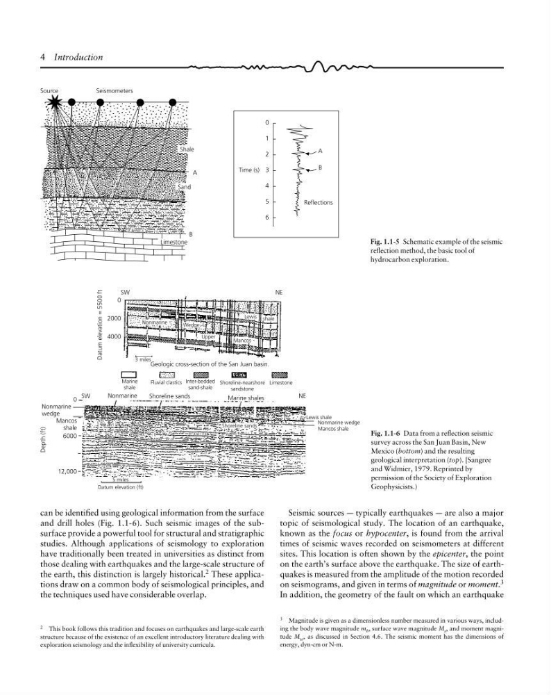
Fig. 1.1-6 Data from a reflection seismic
survey across the San Juan Basin, New
Mexico (bottom) and the resulting
geological interpretation (top). [Sangree
and Widmier, 1979. Reprinted by
permission of the Society of Exploration
Geophysicists.)
Seismic sources a typically earthquakes a are also a major
topic of seismological study. The location of an earthquake,
known as the focus or hypocenter, is found from the arrival
times of seismic waves recorded on seismometers at different
sites. This location is often shown by the epicenter, the point
on the earth’s surface above the earthquake. The size of earthquakes is measured from the amplitude of the motion recorded
on seismograms, and given in terms of magnitude or moment. 3
In addition, the geometry of the fault on which an earthquake
2 This book follows this tradition and focuses on earthquakes and large-scale earth
structure because of the existence of an excellent introductory literature dealing with
exploration seismology and the inflexibility of university curricula.
3 Magnitude is given as a dimensionless number measured in various ways, including the body wave magnitude m b , surface wave magnitude M s , and moment magnitude M w , as discussed in Section 4.6. The seismic moment has the dimensions of
energy, dyn-cm or N-m.
can be identified using geological information from the surface
and drill holes (Fig. 1.1-6). Such seismic images of the subsurface provide a powerful tool for structural and stratigraphic
studies. Although applications of seismology to exploration
have traditionally been treated in universities as distinct from
those dealing with earthquakes and the large-scale structure of
the earth, this distinction is largely historical. 2 These applications draw on a common body of seismological principles, and
the techniques used have considerable overlap.
Fig. 1.1-5 Schematic example of the seismic
reflection method, the basic tool of
hydrocarbon exploration.
Source
Seismometers
Shale
Sand
A
B
Limestone
0
Reflections
A
B
1
2
3
4
5
6
Time (s)
Depth (ft)
Nonmarine
wedge
Mancos
shale
Lewis shale
Nonmarine wedge
Mancos shale
5 miles
Datum elevation (ft)
6000
12,000
Nonmarine
Shoreline sands
Marine
shale
Fluvial clastics Inter-bedded
sand-shale
Shoreline-nearshore
sandstone
Limestone
Marine shales
Geologic cross-section of the San Juan basin.
3 miles
0
2000
4000
Datum elevation = 5500 ft
SW
NE
Nonmarine
NE
SW
0
Wedge
Upper
Mancos
Lewis shale
Shoreline sands
Fig. 1.1-6 Data from a reflection seismic
survey across the San Juan Basin, New
Mexico (bottom) and the resulting
geological interpretation (top). [Sangree
and Widmier, 1979. Reprinted by
permission of the Society of Exploration
Geophysicists.)
Seismic sources a typically earthquakes a are also a major
topic of seismological study. The location of an earthquake,
known as the focus or hypocenter, is found from the arrival
times of seismic waves recorded on seismometers at different
sites. This location is often shown by the epicenter, the point
on the earth’s surface above the earthquake. The size of earthquakes is measured from the amplitude of the motion recorded
on seismograms, and given in terms of magnitude or moment. 3
In addition, the geometry of the fault on which an earthquake
2 This book follows this tradition and focuses on earthquakes and large-scale earth
structure because of the existence of an excellent introductory literature dealing with
exploration seismology and the inflexibility of university curricula.
3 Magnitude is given as a dimensionless number measured in various ways, including the body wave magnitude m b , surface wave magnitude M s , and moment magnitude M w , as discussed in Section 4.6. The seismic moment has the dimensions of
energy, dyn-cm or N-m.
can be identified using geological information from the surface
and drill holes (Fig. 1.1-6). Such seismic images of the subsurface provide a powerful tool for structural and stratigraphic
studies. Although applications of seismology to exploration
have traditionally been treated in universities as distinct from
those dealing with earthquakes and the large-scale structure of
the earth, this distinction is largely historical. 2 These applications draw on a common body of seismological principles, and
the techniques used have considerable overlap.
Fig. 1.1-5 Schematic example of the seismic
reflection method, the basic tool of
hydrocarbon exploration.