

74
M. D. Alba-Rodríguez et al.
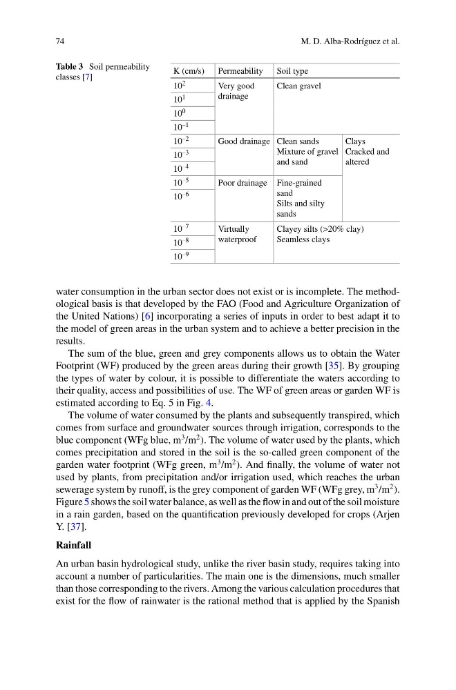
Table 3 Soil permeability
classes [7]
K (cm/s)
Permeability
Soil type
10 2
Very good
drainage
Clean gravel
10 1
10 0
10 –1
10 –2
Good drainage Clean sands
Mixture of gravel
and sand
Clays
Cracked and
altered
10 –3
10 –4
10 –5
Poor drainage Fine-grained
sand
Silts and silty
sands
10 –6
10 –7
Virtually
waterproof
Clayey silts (>20% clay)
Seamless clays
10 –8
10 –9
water consumption in the urban sector does not exist or is incomplete. The methodological basis is that developed by the FAO (Food and Agriculture Organization of
the United Nations) [6] incorporating a series of inputs in order to best adapt it to
the model of green areas in the urban system and to achieve a better precision in the
results.
The sum of the blue, green and grey components allows us to obtain the Water
Footprint (WF) produced by the green areas during their growth [35]. By grouping
the types of water by colour, it is possible to differentiate the waters according to
their quality, access and possibilities of use. The WF of green areas or garden WF is
estimated according to Eq. 5 in Fig. 4.
The volume of water consumed by the plants and subsequently transpired, which
comes from surface and groundwater sources through irrigation, corresponds to the
blue component (WFg blue, m
3 /m
2 ). The volume of water used by the plants, which
comes precipitation and stored in the soil is the so-called green component of the
garden water footprint (WFg green, m
3 /m
2 ). And finally, the volume of water not
used by plants, from precipitation and/or irrigation used, which reaches the urban
sewerage system by runoff, is the grey component of garden WF (WFg grey, m
3 /m
2 ).
Figure 5 shows the soil water balance, as well as the flow in and out of the soil moisture
in a rain garden, based on the quantification previously developed for crops (Arjen
Y. [37].
Rainfall
An urban basin hydrological study, unlike the river basin study, requires taking into
account a number of particularities. The main one is the dimensions, much smaller
than those corresponding to the rivers. Among the various calculation procedures that
exist for the flow of rainwater is the rational method that is applied by the Spanish
M. D. Alba-Rodríguez et al.
Table 3 Soil permeability
classes [7]
K (cm/s)
Permeability
Soil type
10 2
Very good
drainage
Clean gravel
10 1
10 0
10 –1
10 –2
Good drainage Clean sands
Mixture of gravel
and sand
Clays
Cracked and
altered
10 –3
10 –4
10 –5
Poor drainage Fine-grained
sand
Silts and silty
sands
10 –6
10 –7
Virtually
waterproof
Clayey silts (>20% clay)
Seamless clays
10 –8
10 –9
water consumption in the urban sector does not exist or is incomplete. The methodological basis is that developed by the FAO (Food and Agriculture Organization of
the United Nations) [6] incorporating a series of inputs in order to best adapt it to
the model of green areas in the urban system and to achieve a better precision in the
results.
The sum of the blue, green and grey components allows us to obtain the Water
Footprint (WF) produced by the green areas during their growth [35]. By grouping
the types of water by colour, it is possible to differentiate the waters according to
their quality, access and possibilities of use. The WF of green areas or garden WF is
estimated according to Eq. 5 in Fig. 4.
The volume of water consumed by the plants and subsequently transpired, which
comes from surface and groundwater sources through irrigation, corresponds to the
blue component (WFg blue, m
3 /m
2 ). The volume of water used by the plants, which
comes precipitation and stored in the soil is the so-called green component of the
garden water footprint (WFg green, m
3 /m
2 ). And finally, the volume of water not
used by plants, from precipitation and/or irrigation used, which reaches the urban
sewerage system by runoff, is the grey component of garden WF (WFg grey, m
3 /m
2 ).
Figure 5 shows the soil water balance, as well as the flow in and out of the soil moisture
in a rain garden, based on the quantification previously developed for crops (Arjen
Y. [37].
Rainfall
An urban basin hydrological study, unlike the river basin study, requires taking into
account a number of particularities. The main one is the dimensions, much smaller
than those corresponding to the rivers. Among the various calculation procedures that
exist for the flow of rainwater is the rational method that is applied by the Spanish