

2.1 Characteristics of Various Sensor Data
Aircraft and satellites are the common platforms from which remote sensing observations are made. Environmental satellites carry two types of sensors, electro-optical
sensors and synthetic aperture radar (SAR) for gathering data from the earth’s
surface. Most of the electro-optical sensors are passive instruments that capture
reflected energy from the sun and therefore only operate during the daytime and in
cloud-free environments. Active scanners such as SAR supply their own energy
source that bounces off the target and is captured by the instrument. SAR is therefore
used at night and in areas such as the tropics that are cloud covered for most of the
year. An example of an active sensor is RADARSAT, a Canadian radar sensor.
Most remote sensing images are from electro-optical sensors such as aerial
photography and multispectral scanners. The commonly used electro-optical imageries are described below.
Panchromatic Imagery Panchromatic imagery is represented as black and white
and acquired by a digital sensor that measures reflectance in one wide portion of the
electromagnetic spectrum. These wavelength portions of the spectrum are often
called bands. For most current panchromatic sensors, this single band usually
spans the visible to near-infrared part of the spectrum. Panchromatic images are
reliable for identification of land forms, erosional and depositional features, disturbed land, many kinds of man-made features, and land/water interface.
Multispectral Imagery Multispectral imagery is acquired by a digital sensor that
measures reflectance in many wavelengths or bands. These multiple reflectance
values are combined to create color images. The nature of multispectral data
makes them attractive for land use/cover and surface character analysis.
Hyperspectral Imagery Hyperspectral imagery refers to a spectral sensor capable of
measuring reflectance in many individual bands (up to 250) of the electromagnetic
spectrum. The theory behind hyperspectral sensing is that measurement of reflectance in numerous narrow portions of the spectrum can detect very subtle characteristics and differences among surface features.
Some of the most commonly used data from passive sensors comes from the
Landsat MSS, Landsat TM, Landsat ETM, SPOT P, SPOT XS, and IRS1-C/D
sensors. One of the newest sensors to recently go into orbit is Space Imaging
IKONOS sensor. Launched on September 24, 1999, the Ikonos-2 satellite provides
1 m panchromatic data and 4 m multispectral data, paving the way for highly
<0.003 µm 0.001µm 0.01 µm
0.4 µm 0.7 µm 1.5 µm
1 mm
0.8 m
> 0.8 m wavelength
Visible
Near Infrared 0.7 – 1.5 µm
J-rays X-rays
Ultra-voilet
Infrared
Microwave Radio waves
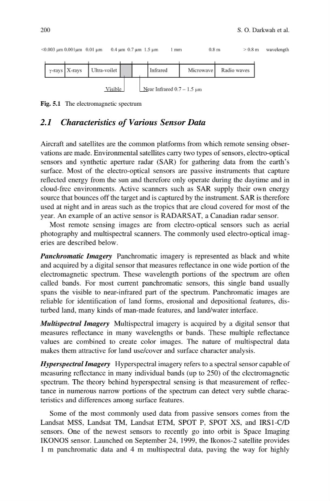
Fig. 5.1 The electromagnetic spectrum
200
S. O. Darkwah et al.
Aircraft and satellites are the common platforms from which remote sensing observations are made. Environmental satellites carry two types of sensors, electro-optical
sensors and synthetic aperture radar (SAR) for gathering data from the earth’s
surface. Most of the electro-optical sensors are passive instruments that capture
reflected energy from the sun and therefore only operate during the daytime and in
cloud-free environments. Active scanners such as SAR supply their own energy
source that bounces off the target and is captured by the instrument. SAR is therefore
used at night and in areas such as the tropics that are cloud covered for most of the
year. An example of an active sensor is RADARSAT, a Canadian radar sensor.
Most remote sensing images are from electro-optical sensors such as aerial
photography and multispectral scanners. The commonly used electro-optical imageries are described below.
Panchromatic Imagery Panchromatic imagery is represented as black and white
and acquired by a digital sensor that measures reflectance in one wide portion of the
electromagnetic spectrum. These wavelength portions of the spectrum are often
called bands. For most current panchromatic sensors, this single band usually
spans the visible to near-infrared part of the spectrum. Panchromatic images are
reliable for identification of land forms, erosional and depositional features, disturbed land, many kinds of man-made features, and land/water interface.
Multispectral Imagery Multispectral imagery is acquired by a digital sensor that
measures reflectance in many wavelengths or bands. These multiple reflectance
values are combined to create color images. The nature of multispectral data
makes them attractive for land use/cover and surface character analysis.
Hyperspectral Imagery Hyperspectral imagery refers to a spectral sensor capable of
measuring reflectance in many individual bands (up to 250) of the electromagnetic
spectrum. The theory behind hyperspectral sensing is that measurement of reflectance in numerous narrow portions of the spectrum can detect very subtle characteristics and differences among surface features.
Some of the most commonly used data from passive sensors comes from the
Landsat MSS, Landsat TM, Landsat ETM, SPOT P, SPOT XS, and IRS1-C/D
sensors. One of the newest sensors to recently go into orbit is Space Imaging
IKONOS sensor. Launched on September 24, 1999, the Ikonos-2 satellite provides
1 m panchromatic data and 4 m multispectral data, paving the way for highly
<0.003 µm 0.001µm 0.01 µm
0.4 µm 0.7 µm 1.5 µm
1 mm
0.8 m
> 0.8 m wavelength
Visible
Near Infrared 0.7 – 1.5 µm
J-rays X-rays
Ultra-voilet
Infrared
Microwave Radio waves
Fig. 5.1 The electromagnetic spectrum
200
S. O. Darkwah et al.