

4.2 Results of the Validation
79
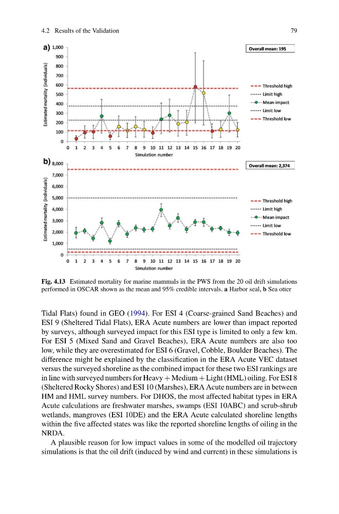
Fig. 4.13 Estimated mortality for marine mammals in the PWS from the 20 oil drift simulations
performed in OSCAR shown as the mean and 95% credible intervals. a Harbor seal, b Sea otter
Tidal Flats) found in GEO (1994). For ESI 4 (Coarse-grained Sand Beaches) and
ESI 9 (Sheltered Tidal Flats), ERA Acute numbers are lower than impact reported
by surveys, although surveyed impact for this ESI type is limited to only a few km.
For ESI 5 (Mixed Sand and Gravel Beaches), ERA Acute numbers are also too
low, while they are overestimated for ESI 6 (Gravel, Cobble, Boulder Beaches). The
difference might be explained by the classification in the ERA Acute VEC dataset
versus the surveyed shoreline as the combined impact for these two ESI rankings are
in line with surveyed numbers for Heavy + Medium + Light (HML) oiling. For ESI 8
(Sheltered Rocky Shores) and ESI 10 (Marshes), ERA Acute numbers are in between
HM and HML survey numbers. For DHOS, the most affected habitat types in ERA
Acute calculations are freshwater marshes, swamps (ESI 10ABC) and scrub-shrub
wetlands, mangroves (ESI 10DE) and the ERA Acute calculated shoreline lengths
within the five affected states was like the reported shoreline lengths of oiling in the
NRDA.
A plausible reason for low impact values in some of the modelled oil trajectory
simulations is that the oil drift (induced by wind and current) in these simulations is
79
Fig. 4.13 Estimated mortality for marine mammals in the PWS from the 20 oil drift simulations
performed in OSCAR shown as the mean and 95% credible intervals. a Harbor seal, b Sea otter
Tidal Flats) found in GEO (1994). For ESI 4 (Coarse-grained Sand Beaches) and
ESI 9 (Sheltered Tidal Flats), ERA Acute numbers are lower than impact reported
by surveys, although surveyed impact for this ESI type is limited to only a few km.
For ESI 5 (Mixed Sand and Gravel Beaches), ERA Acute numbers are also too
low, while they are overestimated for ESI 6 (Gravel, Cobble, Boulder Beaches). The
difference might be explained by the classification in the ERA Acute VEC dataset
versus the surveyed shoreline as the combined impact for these two ESI rankings are
in line with surveyed numbers for Heavy + Medium + Light (HML) oiling. For ESI 8
(Sheltered Rocky Shores) and ESI 10 (Marshes), ERA Acute numbers are in between
HM and HML survey numbers. For DHOS, the most affected habitat types in ERA
Acute calculations are freshwater marshes, swamps (ESI 10ABC) and scrub-shrub
wetlands, mangroves (ESI 10DE) and the ERA Acute calculated shoreline lengths
within the five affected states was like the reported shoreline lengths of oiling in the
NRDA.
A plausible reason for low impact values in some of the modelled oil trajectory
simulations is that the oil drift (induced by wind and current) in these simulations is