

4.1 Method of Validation Against Historic Spills
69
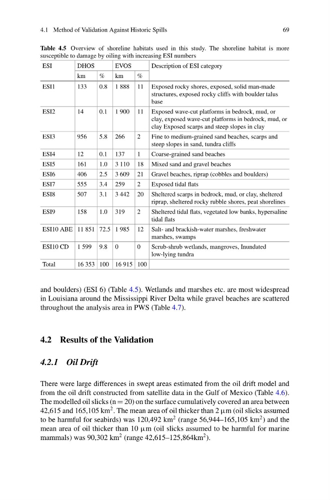
Table 4.5 Overview of shoreline habitats used in this study. The shoreline habitat is more
susceptible to damage by oiling with increasing ESI numbers
ESI
DHOS
EVOS
Description of ESI category
km
%
km
%
ESI1
133
0.8 1 888 11 Exposed rocky shores, exposed, solid man-made
structures, exposed rocky cliffs with boulder talus
base
ESI2
14
0.1 1 900 11 Exposed wave-cut platforms in bedrock, mud, or
clay, exposed wave-cut platforms in bedrock, mud, or
clay Exposed scarps and steep slopes in clay
ESI3
956
5.8 266
2
Fine to medium-grained sand beaches, scarps and
steep slopes in sand, tundra cliffs
ESI4
12
0.1 137
1
Coarse-grained sand beaches
ESI5
161
1.0 3 110 18 Mixed sand and gravel beaches
ESI6
406
2.5 3 609 21 Gravel beaches, riprap (cobbles and boulders)
ESI7
555
3.4 259
2
Exposed tidal flats
ESI8
507
3.1 3 442 20 Sheltered scarps in bedrock, mud, or clay, sheltered
riprap, sheltered rocky rubble shores, peat shorelines
ESI9
158
1.0 319
2
Sheltered tidal flats, vegetated low banks, hypersaline
tidal flats
ESI10 ABE 11 851 72.5 1 985 12 Salt- and brackish-water marshes, freshwater
marshes, swamps
ESI10 CD 1 599 9.8 0
0
Scrub-shrub wetlands, mangroves, Inundated
low-lying tundra
Total
16 353 100 16 915 100
and boulders) (ESI 6) (Table 4.5). Wetlands and marshes etc. are most widespread
in Louisiana around the Mississippi River Delta while gravel beaches are scattered
throughout the analysis area in PWS (Table 4.7).
4.2 Results of the Validation
4.2.1 Oil Drift
There were large differences in swept areas estimated from the oil drift model and
from the oil drift constructed from satellite data in the Gulf of Mexico (Table 4.6).
The modelled oil slicks (n = 20) on the surface cumulatively covered an area between
42,615 and 165,105 km
2 . The mean area of oil thicker than 2 µm (oil slicks assumed
to be harmful for seabirds) was 120,492 km
2 (range 56,944–165,105 km
2 ) and the
mean area of oil thicker than 10 µm (oil slicks assumed to be harmful for marine
mammals) was 90,302 km
2 (range 42,615–125,864km
2 ).
69
Table 4.5 Overview of shoreline habitats used in this study. The shoreline habitat is more
susceptible to damage by oiling with increasing ESI numbers
ESI
DHOS
EVOS
Description of ESI category
km
%
km
%
ESI1
133
0.8 1 888 11 Exposed rocky shores, exposed, solid man-made
structures, exposed rocky cliffs with boulder talus
base
ESI2
14
0.1 1 900 11 Exposed wave-cut platforms in bedrock, mud, or
clay, exposed wave-cut platforms in bedrock, mud, or
clay Exposed scarps and steep slopes in clay
ESI3
956
5.8 266
2
Fine to medium-grained sand beaches, scarps and
steep slopes in sand, tundra cliffs
ESI4
12
0.1 137
1
Coarse-grained sand beaches
ESI5
161
1.0 3 110 18 Mixed sand and gravel beaches
ESI6
406
2.5 3 609 21 Gravel beaches, riprap (cobbles and boulders)
ESI7
555
3.4 259
2
Exposed tidal flats
ESI8
507
3.1 3 442 20 Sheltered scarps in bedrock, mud, or clay, sheltered
riprap, sheltered rocky rubble shores, peat shorelines
ESI9
158
1.0 319
2
Sheltered tidal flats, vegetated low banks, hypersaline
tidal flats
ESI10 ABE 11 851 72.5 1 985 12 Salt- and brackish-water marshes, freshwater
marshes, swamps
ESI10 CD 1 599 9.8 0
0
Scrub-shrub wetlands, mangroves, Inundated
low-lying tundra
Total
16 353 100 16 915 100
and boulders) (ESI 6) (Table 4.5). Wetlands and marshes etc. are most widespread
in Louisiana around the Mississippi River Delta while gravel beaches are scattered
throughout the analysis area in PWS (Table 4.7).
4.2 Results of the Validation
4.2.1 Oil Drift
There were large differences in swept areas estimated from the oil drift model and
from the oil drift constructed from satellite data in the Gulf of Mexico (Table 4.6).
The modelled oil slicks (n = 20) on the surface cumulatively covered an area between
42,615 and 165,105 km
2 . The mean area of oil thicker than 2 µm (oil slicks assumed
to be harmful for seabirds) was 120,492 km
2 (range 56,944–165,105 km
2 ) and the
mean area of oil thicker than 10 µm (oil slicks assumed to be harmful for marine
mammals) was 90,302 km
2 (range 42,615–125,864km
2 ).