

the soils are dominated by silty sand, find sand and the like with high salt content
and penetration rate for pollutants, being adjacent to the East China Sea.
Secondarily, the large precipitation and long duration of rainy seasons cause a quite
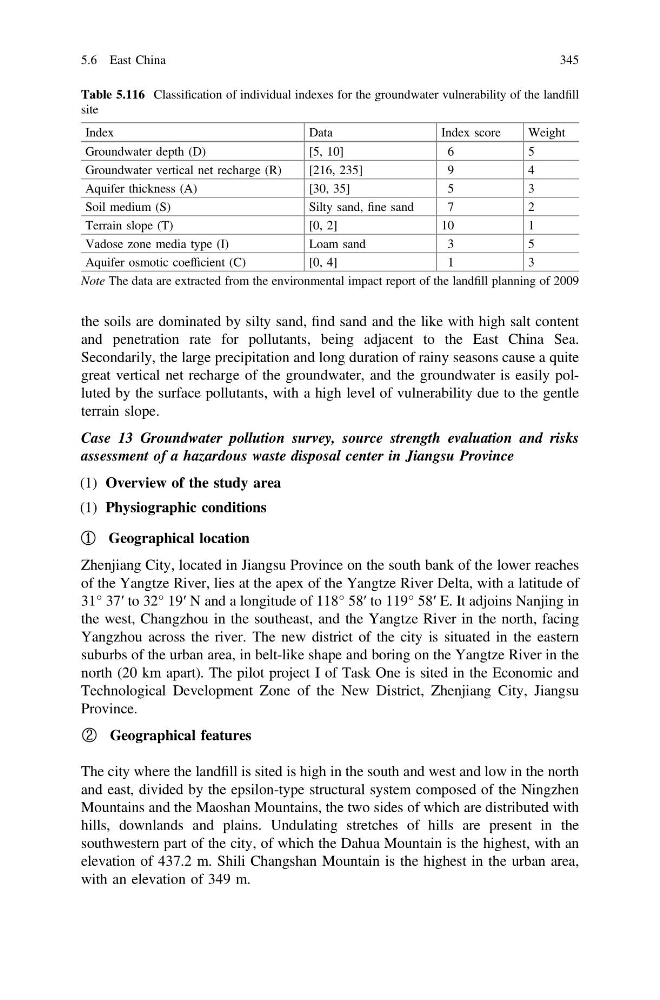
great vertical net recharge of the groundwater, and the groundwater is easily polluted by the surface pollutants, with a high level of vulnerability due to the gentle
terrain slope.
Case 13 Groundwater pollution survey, source strength evaluation and risks
assessment of a hazardous waste disposal center in Jiangsu Province
(1) Overview of the study area
(1) Physiographic conditions
① Geographical location
Zhenjiang City, located in Jiangsu Province on the south bank of the lower reaches
of the Yangtze River, lies at the apex of the Yangtze River Delta, with a latitude of
31° 37′ to 32° 19′ N and a longitude of 118° 58′ to 119° 58′ E. It adjoins Nanjing in
the west, Changzhou in the southeast, and the Yangtze River in the north, facing
Yangzhou across the river. The new district of the city is situated in the eastern
suburbs of the urban area, in belt-like shape and boring on the Yangtze River in the
north (20 km apart). The pilot project I of Task One is sited in the Economic and
Technological Development Zone of the New District, Zhenjiang City, Jiangsu
Province.
② Geographical features
The city where the landfill is sited is high in the south and west and low in the north
and east, divided by the epsilon-type structural system composed of the Ningzhen
Mountains and the Maoshan Mountains, the two sides of which are distributed with
hills, downlands and plains. Undulating stretches of hills are present in the
southwestern part of the city, of which the Dahua Mountain is the highest, with an
elevation of 437.2 m. Shili Changshan Mountain is the highest in the urban area,
with an elevation of 349 m.
Table 5.116 Classification of individual indexes for the groundwater vulnerability of the landfill
site
Index
Data
Index score
Weight
Groundwater depth (D)
[5, 10]
6
5
Groundwater vertical net recharge (R)
[216, 235]
9
4
Aquifer thickness (A)
[30, 35]
5
3
Soil medium (S)
Silty sand, fine sand
7
2
Terrain slope (T)
[0, 2]
10
1
Vadose zone media type (I)
Loam sand
3
5
Aquifer osmotic coefficient (C)
[0, 4]
1
3
Note The data are extracted from the environmental impact report of the landfill planning of 2009
5.6 East China
345
and penetration rate for pollutants, being adjacent to the East China Sea.
Secondarily, the large precipitation and long duration of rainy seasons cause a quite
great vertical net recharge of the groundwater, and the groundwater is easily polluted by the surface pollutants, with a high level of vulnerability due to the gentle
terrain slope.
Case 13 Groundwater pollution survey, source strength evaluation and risks
assessment of a hazardous waste disposal center in Jiangsu Province
(1) Overview of the study area
(1) Physiographic conditions
① Geographical location
Zhenjiang City, located in Jiangsu Province on the south bank of the lower reaches
of the Yangtze River, lies at the apex of the Yangtze River Delta, with a latitude of
31° 37′ to 32° 19′ N and a longitude of 118° 58′ to 119° 58′ E. It adjoins Nanjing in
the west, Changzhou in the southeast, and the Yangtze River in the north, facing
Yangzhou across the river. The new district of the city is situated in the eastern
suburbs of the urban area, in belt-like shape and boring on the Yangtze River in the
north (20 km apart). The pilot project I of Task One is sited in the Economic and
Technological Development Zone of the New District, Zhenjiang City, Jiangsu
Province.
② Geographical features
The city where the landfill is sited is high in the south and west and low in the north
and east, divided by the epsilon-type structural system composed of the Ningzhen
Mountains and the Maoshan Mountains, the two sides of which are distributed with
hills, downlands and plains. Undulating stretches of hills are present in the
southwestern part of the city, of which the Dahua Mountain is the highest, with an
elevation of 437.2 m. Shili Changshan Mountain is the highest in the urban area,
with an elevation of 349 m.
Table 5.116 Classification of individual indexes for the groundwater vulnerability of the landfill
site
Index
Data
Index score
Weight
Groundwater depth (D)
[5, 10]
6
5
Groundwater vertical net recharge (R)
[216, 235]
9
4
Aquifer thickness (A)
[30, 35]
5
3
Soil medium (S)
Silty sand, fine sand
7
2
Terrain slope (T)
[0, 2]
10
1
Vadose zone media type (I)
Loam sand
3
5
Aquifer osmotic coefficient (C)
[0, 4]
1
3
Note The data are extracted from the environmental impact report of the landfill planning of 2009
5.6 East China
345